Göteborg sjunker! EarthCache
-
Difficulty:
-

-
Terrain:
-
Size:  (other)
Please note Use of geocaching.com services is subject to the terms and conditions
in our disclaimer.
Press here for English!
[Svenska]
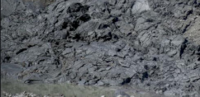
Göteborg har en väldigt unik geologi på det sättet att staden är byggd på lera. Detta medför flera geologiska processer som blottas på stan. En av dessa geologiska effekter som är kopplad till geologin kring Göeborgsleran är just att marken på vissa platser i staden sjunker ner i leran, så kallade sättningar. Vid koordinaterna för denna Earthcache kan man tydligt se tecken på dessa sättningar som Göteborgsleran bidrar till.
Göteborgsleran är den lera som hela staden vilar på. Göteborgslerans geologiska egenskaper är att den är 10 000 år gammal och har varit ganska lös från början men blivit mer kompakt under de senare åren. Utifrån ett sättningsperspektiv är detta positivt eftersom leran när den är lös är känsligare för grundvattenförändringar medan när Göteborgsleran är mer kompakt är den inte lika känslig för grundvattenförändringar. Detta innebär i sin helhet att sättningshastigheten under den senaste åren har minskat eftersom leran har ändrat sina geologiska egenskaper vilka är förutsättningar för att sättningar skall åstakomma. Göteborgsleran har också den egenskapen att trycket blir högre ju längre ner man kommer i leran.
Experter i geolgi och geoteknik på Chalmers skriver så här om leran "Med geotekniska undersökningar som bas i kombination med ny kunskap kan man göra förhållandevis säkra prognoser av vilka sättningar som kommer att uppstå vid olika förändringar."
De sättningar som finns runt om i Göteborgsområdet har uppstått till följd av att Göteborgsleran har kompakterats, det vill säga tryckts ihop. Sättningar orsakas nämligen av att underliggande jord och lera blir mer kompakt. Sättningarna som finns här i Göteborg kan ha uppstått av flera anledningar, några är att belastningen på marken har ökat, att grundvattennivån har ändrats. Grundvattnet är en viktig faktor för sättningar i Göteborg eftersom grundvattnet har en stor påverkan på Göteborgsleran, ändras grundvattnet på fel sätt kan Göteborgsleran komma att tryckas ihop och marken komma att sjunka ner ännu mer, alltså blir det större sättningar. Sättningar kan även orsakas av att uttorkning av lera och jord vilket där även vattnet har en avgörande faktor för att undvika detta. Sättningar kan vara olika tydliga beroende på hur det ser ut i omgivningen, det tydligaste tecknet på sättningar och att marken har sjunkit ner här i Göteborg är att husen där sättningen finns har börjat att luta eftersom marken sjunkit ner på ena sidan av huset medan andra sidan intne sjunkit alls, eller åtminstonde inte mycket, se bilder nedan för exempel på hus som lutar på grund av sättningar.

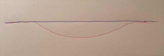
På bilden ovan kan du se hur sättningar i Göteborgsområdet kan orienteras. Den blå markeringen visar hur marken ser ut om det inte hade varit sättningar på platsen. Den röda visar hur marken kan se ut där det är en sättning i Göteborgsområdet. Om man jämför de röda och blå markeringarna i kombination med ett besök på platsen där en sättning finns kan man orientera sig i hur sättningen går. Som jag nämnde ovan är det vanligt att där det finns sättningar att hus(en) omkring har börjat att luta till följd av att marken har sjunkit ner i leran. Om det finns flera hus på platsen kan man jämföra deras lutning och med hjälp av det kan man orientera sig i kartan ovan var mitten av sättningen finns.
Marken i Göteborg sjunker ner olika mycket på olika ställen, generellt sätt så sjunker marken ner 1 mm per år mern närmare älven kna marken sjunka med upp till 7 mm per år. På koordinaterna för denna Earthcache har man mätt upp att marken har sjunkit med upp till 5mm per år. Dessa siffror låter kan ske lite men om tittar på ett år men om man ser det på längre sikt är detta mycket stora siffror.
Sättningar som medför att marken sjunker ner är ett stort problem här i Göteborg och orsakar oro hos många invånare i staden. Förutom vid koordinaterna där man kan se sättningar tydligt kan man även se detta mycket tydligt i Haga och på många fler ställen.
Loggnings instruktioner
>
För att kunna logga cachen skall du svara på följande frågor:
1. Beskriv hur du kan se att det är en sättning där du befinner dig.
2. Orientera dig i sättningen, var tror du den djupaste delen är?
3. Ta en bild på dig själv eller något personligt objekt med älven i bakgrunden och ladda upp till ding logg.
För att logga cachen skall du maila svaren till mig via min profilsida (länk.) Alternativt skicka svaren till aa1124aa@outlook.com Vid eventuella fel så kontaktar jag dig.
Du behöver inte vänta på svar från mig för att logga!
[English]
Gothenburg has a very unique geology in the way that the city is built on clay. This entails several geological processes that are exposed in the city. One of these geological effects, which is linked to the geology around the Gothenburg clay, is precisely that the ground in certain places in the city falls into the clay, so-called subsidence. At the coordinates of this Earthcache you can clearly see the signs of these geological subsidence that the Gothenburg clay contributes to.
Gothenburg clay is the mud on which the whole city rests. The geological features of the Gothenburg clay are that it is 10,000 years old and has been quite loose from the beginning but has become more compact in recent years. From a subsidence perspective, this is positive because the clay when loose is more sensitive to groundwater changes, while when the Gothenburg clay is more compact, it is not as sensitive to groundwater changes. This, in its entirety, means that the subsidences speed has decreased in recent years as the clay has changed its geological characteristics which are the prerequisites for the subsidence. The Gothenburg clay also has the property that the pressure gets higher the further down you get into the clay.
Experts in geology and geotechnology at Chalmers write about the mud (translated) "With geotechnical surveys as a base in combination with new knowledge, it is possible to make relatively accurate predictions of the subsidence that will occur in various changes."
The subsidence that exist around the Gothenburg area have arisen as a result of the compacting of the Gothenburg clay. Subsidencees are caused by the fact that the underlying soil and clay become more compact. The subsidence found here in Gothenburg may have arisen for subsidence, some being that the load on the ground has increased, that the groundwater level has changed. The groundwater is an important factor for settlements in Gothenburg as the groundwater has a major impact on the Gothenburg clay, if the groundwater is changed incorrectly, the Gothenburg clay may be compressed and the ground will sink even more. Subsidence can also be caused by the dehydration of clay and soil, which where water also has a decisive factor to avoid this. Settlements can be distinctly different depending on how it looks in the surroundings, the clearest sign of subsidence and that the ground has dropped down here in Gothenburg is that the houses where the subsidence is located have started to tilt as the ground has fallen on one side of the house while the other side nothing dropped at all, or at least not much, see pictures below for example of houses tilting due to subsidence.
In the image above you can see how subsidence in the Gothenburg area can be oriented. The blue marking shows what the ground would look like if there had been no subsidence at the site. The red shows how the ground can look where there is a subsidence in the Gothenburg area. If you compare the red and blue markings in combination with a visit to the place where a subsidence is found, you can orient yourself in how the sentence goes. As I mentioned above, it is common that where there are subsidence. that the house (s) around have started to tilt as a result of the ground sinking into the mud. If there are several houses on the site you can compare their slope and with the help of it you can orient themselves in the map above where the center of the subsidence is.
The ground in Gothenburg drops down very much in different places, generally so the ground drops 1 mm per year but closer to the river the ground drops by up to 7 mm per year. On the coordinates of this Earthcache it has been measured that the ground has dropped by up to 5mm per year. These numbers may sound a bit but if you look at a year but if you see it in the longer term, these are very large numbers.
Subsidence that cause the ground to sink are a major problem here in Gothenburg and cause concern for many residents of the city. Apart from the coordinates where you can see this clearly, you can also see this very clearly in Haga and in many more places.
Loggning tasks
>
To log:
1. Describe how you can see that it is a subsidence where you are.
2. Orient the subsidence., where do you think the deepest part is?
3. Take a picture of yourself or some personal object with the river in the background and upload it to your log.
To log, send the answer to me from my profile page (link.) Or send your answer to aa1124aa@outlook.com I Contact you if somthing is wrong. You dont need to wait on answer from me to log!
Additional Hints
(No hints available.)