La Earthcache / The Earthcache
► Contexte géologique local
La route entre Beaune le Froid et Murol passe au travers d'une langue de basalte des plateaux en longeant de hautes falaises verticales.

A un détour de cette route, il est possible de découvrir un véritable mur de mosaïques basaltiques. Comment cette formation si particulière s'est-elle mise en place ?
► Phase 1 : Et le Basalte de Murol fut
Des épisodes stromboliens ont eu lieu pendant le Miocène (entre 10 et 20 millions d'années). Ces volcans ont produit des coulées de laves fluides selon les zones de pente et les fonds des vallées.
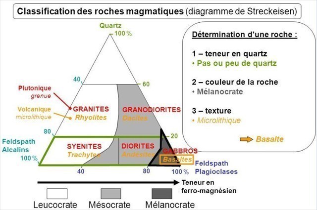
La cristallisation suite au refroidissement de ce magma donne du basalte, une roche grise-bleutée présentant une structure microlithique, c'est à dire à tous petits cristaux.

Sa couleur s'explique par une richesse en minéraux ferromagnésiens comme le pyroxène et l'olivine.
Selon le Diagramme de Streckeisen, on parle alors de roche mélanocrate (sombre).
► Phase 2 : Fentes de retrait et diaclases
Le basalte est une roche dure et cohérente, difficilement altérable.
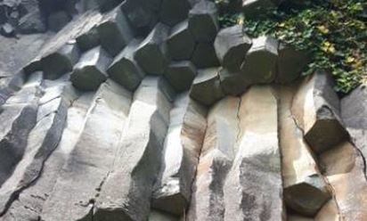
Lors de sa cristallisation, elle subit cependant un phénomène plus ou moins prononcé de contraction thermique par refroidissement. Les formes les plus importantes de ces rétractations conduisent à des prismes réguliers (orgues basaltiques).
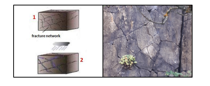
Cependant, même en l'absence d'orgue, des réorganisations dans la roche en refroidissement créent des fentes de retrait où les minéraux sont moins denses.
Par ailleurs, l'intérieur d'un flux de lave est constitué d'une superposition de sous-couches séparées par des accumulations de petites bulles.
Pendant le refroidissement, ces fentes de retrait (ruptures plus ou moins plates et verticales) et les limites entre les unités d'écoulement (zones de faiblesse plutôt horizontales) divisent l'écoulement en blocs à peu près parallélépipédiques.
C'est au niveau de ces zones de faiblesse que des fissures apparaissent, les diaclases.
Elles se présentent comme des fentes quand elles recoupent un flanc de la tranchée et sous la forme de plans bosselés quand elles sont parallèles.
► Phase 3 : Piles d'assiettes et mosaïques
L'eau chargée en gaz carbonique s'infiltre en suivant ces plans de fissuration et mouille la roche pendant de longues périodes.
Lentement, des processus hydrochimiques altèrent les minéraux ferromagnésiens (feldspaths et pyroxène) et "pourrissent" la roche.
C'est par exemple le cas des plagioclases :
2 Al2Si2O8Ca + 4 CO2 + 6 H2O → 2 Ca2+ + 4 HCO3 - + Si4O10Al4(OH)8
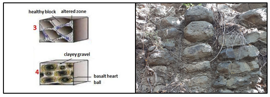
Les fentes de retrait et les bords de prismation étant des zone privilégiées d'attaque par l'eau, cela donne des débits d’altération bien alignés verticalement « en pile d’assiettes ».
Les diaclases vont alors s'élargir et un damier de blocs individualisés de basalte va petit à petit à se mettre en place, formant une véritable mosaïque de parallélépipèdes.
► Phase 4 : Quand le basalte se met en boule
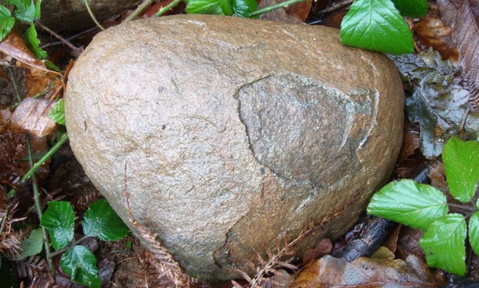
Au cours du processus d'altération, les intersections des diaclases (sommets et arêtes des parallélépipèdes) sont les zones les plus touchées, les coins s'arrondissent.
Au dernier stade de l'altération, les blocs de basalte en cours de dégradation prennent des formes arrondies ou oblongues caractéristiques.
Le processus peut aller jusqu'au détachement de boules de basalte qui chutent au pied de la falaise.
Il s'agit d'un processus d'altération long, la formation d'une boule pouvant prendre 300 000 ans.
► Local geological context
The road between Beaune le Froid and Murol passes through a basalt tongue of the plateaus along high vertical cliffs.
At a detour from this road, it is possible to discover a real wall of basalt mosaics. How did this special training take place?
► Phase 1: And Murol's Basalt was
Strombolian episodes occurred during the Miocene (between 10 and 20 million years ago). These volcanoes produced flowing lava flows according to the slope zones and the valley bottoms.
The crystallization following the cooling of this magma gives basalt, a gray-bluish rock with a microlithic structure, that is to say with all small crystals.
Its color is explained by a wealth of ferromagnesian minerals such as pyroxene and olivine.
According to the Streckeisen Diagram, we then speak of melanocratic (dark) rock.
► Phase 2: Withdrawal slots and joints
Basalt is a hard and coherent rock, difficult to alter.
During its crystallization, however, it undergoes a more or less pronounced phenomenon of thermal contraction by cooling. The most important forms of these retractions lead to regular prisms (basalt organs).
However, even in the absence of an organ, reorganizations in the cooling rock create shrinkage slots where the minerals are less dense.
In addition, the interior of a lava flow consists of a superposition of sub-layers separated by accumulations of small bubbles.
During cooling, these withdrawal slots (more or less flat and vertical ruptures) and the limits between the flow units (rather horizontal zones of weakness) divide the flow into roughly parallelepipedic blocks.
It is in these areas of weakness that cracks appear, the diaclases.
They appear as slits when they cut across a side of the trench and in the form of bumpy planes when they are parallel.
► Phase 3: Stacks of plates and mosaics
The water loaded with carbon dioxide infiltrates following these cracking planes and wets the rock for long periods.
Slowly, hydrochemical processes alter the ferromagnesian minerals (feldspar and pyroxene) and "rot" the rock.
This is for example the case of plagioclases:
2 Al2Si2O8Ca + 4 CO2 + 6 H2O → 2 Ca2 + + 4 HCO3 - + Si4O10Al4 (OH) 8
With the recesses and prismatic edges being preferred areas of water attack, this results in weathering rates that are well aligned vertically "in a stack of plates".
The joints will then widen and a checkerboard of individualized basalt blocks will gradually be put in place, forming a real mosaic of parallelepipeds.
► Phase 4: When the basalt curls
During the alteration process, the intersections of the joints (vertices and edges of the parallelepipeds) are the most affected areas, the corners are rounded.
At the last stage of alteration, the basalt blocks undergoing degradation take on characteristic rounded shapes.
The process can go as far as the detachment of basalt balls which fall at the foot of the cliff.
It is a long alteration process, the formation of a ball can take 300,000 years.
► Sources bibliographiques / Bibliographical sources
Les Questions / The Questions
La lecture attentive du descriptif de la cache, ainsi qu'une observation des éléments de terrain et un peu de déduction sont normalement suffisants pour répondre aux questions de cette EarthCache.
A careful reading of the description of the cache, as well as observation of terrain features and some deduction is usually sufficient to answer questions of this EarthCache.
Questions pour valider :"Mozaïques Basaltiques à Murol"
Questions to validate: "Basalt Mozaics in Murol"
Point PK et photo : N 44° 58.079 E 003° 38.879
Vous voici sur une petite zone de stationnement dans le sens Murol vers Beaune Le Froid.
Avant d'allez au WP1, profitez en pour faire une petite photo.
Here you are in a small parking area in the direction of Murol towards Beaune Le Froid.
Before going to WP1, take the opportunity to take a small photo.
- Question 0 : Prenez sur place une photo de vous ou d'un élément vous identifiant avec la vallée et le château de Murol en arrière plan.
Cette photo devra au choix nous être transmise avec les réponses ou être ajoutée à votre log.
- Question 0 : Take a photo of yourself or something identifying you with the valley and the castle of Murol in the background.
This photo will have to be sent to us with the answers or to be added to your log.
Point 1 : N 44° 58.079 E 003° 38.879
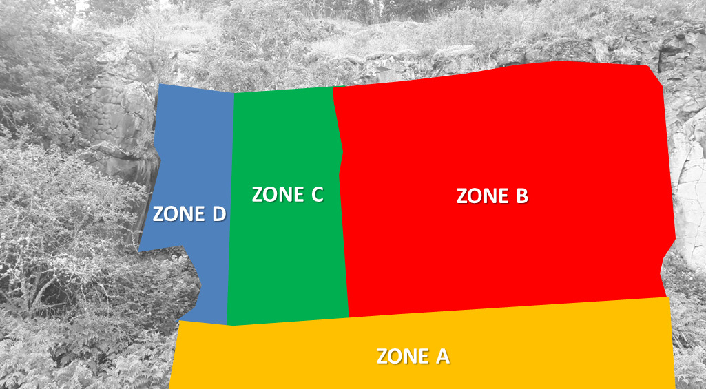
Dirigez vous avec prudence au WP1 en faisant attention à la circulation à la sortie du virage sur la départementale D5. Traversez avec prudence, si possible passez le petit fossé pour être en zone de sécurité par rapport à la route et tournez le dos à la départementale pour étudiez la falaise (photo WP1).
Head carefully to WP1, paying attention to the traffic at the exit of the bend on the departmental D5. Cross with caution, if possible pass the small ditch to be in a safe zone in relation to the road and turn your back on the departmental to study the cliff (photo WP1).
- Question 1 : Cherchez un bloc de roche entre le fossé et la falaise (sans se mettre à l'aplomb de cette falaise, risque de chute de pierres) et étudiez sa couleur et sa texture. Identifiez sa nature en utilisant le diagramme de Streckeisen.
- Question 1 : Look for a block of rock between the ditch and the cliff (without getting in line with this cliff, risk of falling rocks) and study its color and texture. Identify its nature using the Streckeisen diagram.
- Question 2 : La photo WP1 se divise en 4 zones (A, B, C et D). Décrivez chaque zone et identifiez pour chacune la phase d'altération du massif basaltique.
- Question 2 : The WP1 photo is divided into 4 areas (A, B, C and D). Describe each area and identify for each the alteration phase of the basalt massif.
- Question 3 : A quoi vous fait pensez l'allure de la zone B ? Comment expliquer cette disposition ?
- Question 3 : What do you think of the look of zone B? How to explain this provision?
- Question 4 : Décrivez la forme des blocs dans la zone identifiée en phase 4 et expliquez l'origine de cette forme.
- Question 4 : Describe the shape of the blocks in the area identified in phase 4 and explain the origin of this shape.
Vous pouvez vous loguer sans attendre notre confirmation,
mais vous devez nous envoyer les réponses en même temps soit par mail via notre profil (
fafahakkai), soit via la messagerie geocaching.com (Message Center).
S'il y a des problèmes avec vos réponses nous vous en ferons part.
Les logs enregistrés sans réponses et sans photo seront supprimés.
You can log this cache without waiting for our confirmation, but you must send us the answers at the same time, by e-mail via our profile (fafahakkai) or by the system of Message Center of geocaching.com.
If there is a problem with your answers we will notify you. The logs recorded without answers and photo will be deleted.
Rappel concernant les « Earthcaches »: Il n'y a pas de conteneur à rechercher ni de logbook à renseigner. Il suffit de se rendre sur les lieux, de répondre aux questions ci-dessus et de nous renvoyer les réponses.
Reminder concerning "Earthcaches": there is neither a container to look for nor a logbook to sign. One need only go to the location, answer to the differents questions and send us the answers.