Welcome to the
Indiana Dunes National Park
Dunes are so much more than just a pile of sand. How they form, where they form, and what shape they form are all important factors as to how they influence the landscape and vegetation around them. Rising about 126 feet above the lake's surface, Mt. Baldy might be one of the most recognizable features of the Indiana Dunes National Park.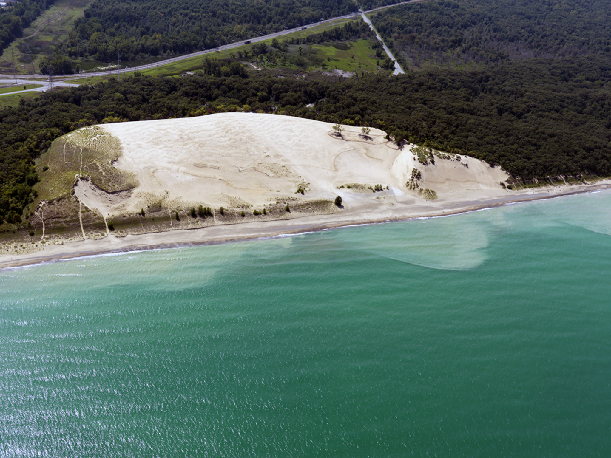 Mt. Baldy has stood fast along the southern shoreline of Lake Michigan for the last 3,500 years. However, within the last 200 years the dune itself has taken on a strikingly new appearance and behavior. Not only is Mt. Baldy among the tallest dunes in the park, it is also one of the fastest. Why is Mt. Baldy on the move? To understand why Mt. Baldy looks and behaves the way it does, we must first understand the factors that contributed to its development. This EarthCache will explore the various biotic (living) and abiotic (non-living) processes that contributed to form this dune, and we’ll see what consequences they have had on Mt. Baldy as they have changed over time. So, let’s see how the sands of time have affected this gem on the southern shoreline..
Help save Mt. Baldy by staying on the designated trails at all times and following posted signage.
Note: The Summit to Mt. Baldy is closed to the public. You will not need to climb any portion of the dune except on designated trails to complete this cache.
To Log This Cache…
Please do not post any answers in your log.
Message us with your answers and observations to the following questions:
Got your answers all submitted? Don't wait to log the cache, we'll reply back to you should you need help with an answer or two.
In order to log this cache, you’ll need a few tools of the trade (TOTTs): 1) something to measure angles like a protractor, compass, or smartphone. 2) Something to measure elevation like a GPS or smartphone. 3) about 20 oz. of water to pour into the ground - optional
Stop 1- Base of the Slipface
- Take a look at the dune before you. Look at the colors within the sand, each of those colors is a different mineral. Quartz looks clear, feldspar green, garnet red, etc. Which one is the most dominant?
- Optional: What product do you think would be made from the sand on our shorelines? Was this the fate of Hoosier Slide? Check out this article for information.
- Using something to measure angles (see TOTTs above), calculate the angle of the slip face. What is that angle?
- Optional: Why do you think a dune cannot maintain an angle beyond this?
- Optional: Pour about 4-5 oz. of water on portion of the slip face close to the ground.
- How long does it take to absorb into the sand?
- Using your smartphone or GPS take an elevation reading.
Stop 2- Intersection in trail
- Let’s look at the soil. How dark is it? Does it appear moist or dry?
- Optional: Pour about 4-5 oz. of water on a flat part of the trail. How long does it take to absorb into the ground? Does it retain water longer, shorter, or about the same as the sand at Stop 1? What do you think this means about the age of the ground around you in comparison to stop 1?
- If you opt out of the water experiment, observe and speculate: If you poured water on it, does it look like it would retain the water longer, shorter, or about the same as sand? What do you think that means about the age of the ground you are standing in comparison to the age of the sand you saw at Stop 1?
- Compare the environment between this area and Stop 1. Does this appear to be a stabilized portion of the dune?
- As you walk from Stop 2 to Stop 3 pay attention to the soil. When does it start the transition from dark soil to beachy sand? What does the surrounding vegetation look like; is it still a forest or starting to open into a grass-covered dune area?
- Using your smartphone or GPS take an elevation reading. How does it differ from Stop 1?
Stop 3- The beach
- Examine the sand on the beach. How does it compare to both Stop 1 and Stop 2? Is the size of the grain the same at all 3 stops? Is there any other debris or objects like cobble stones or gravel on the beach? Is there a lot of vegetation?
-
- *If present, the cobble is fill from a previous attempt to stabilize the shoreline. This fill is washed ashore and helps protect sand beneath it from being blown away.
- Do you notice something that appears to be large rocks scattered throughout the area? This is an ancient clay layer that has been exposed due to shoreline erosion. This clay layer was formed over 6,500 years ago during a period when the lake was much further north and this area was a wetland like the Great Marsh. Almost impervious to water, as water seeps through Mt. Baldy it eventually reaches this clay layer. The clay layer stops the water from traveling any deeper and forces it to look for another exit, typically back towards the lake.
- Walk down the beach and center yourself with the dune. Look at the dune from east to west (left to right). Is it the entire dune that lacks sand-stabilizing vegetation or one portion of the dune?
- Starting towards the base of the dune scan upward looking for a dark line. That line is the layer of paleosol. Using your smartphone or GPS take an elevation reading. Estimate how high above the shoreline the paleosol line is. Looking at all these elevation readings, how does everything compare over the distance you walked since stop 1?
- If the wind is blowing: Do you see any sand moving? Do you see how the individual grains interact with each other? If so, what process of grain movement are you witnessing?
- Optional: Pour about 4-5 oz. of water on portion of the slip face close to the ground. How long does it take to absorb into the sand?
Final Questions - optional
- Thinking about all your observations, what are some things that can be done to help stabilize Mt. Baldy?
- As you look across Mt. Baldy, do you see any signs of it starting to recover?
- Look at the dune cliffs closest to the shoreline, do you see any grasses? Are their roots exposed? If so, look at its network of rhizomes, or roots. Estimate how deep into the dune they go. It is this complex network of marram grass roots that allow a dune to stabilize in place.
Geologic Processes
Around 20,000 years ago, Northwest Indiana was covered by a sheet of ice called a glacier. This continental-sized glacier extended south from the arctic covering much of the northern part of the United States from North Dakota to the Northeast, in a sheet of ice tens-of-thousands of feet thick. In Northwest Indiana, the lobe of glacial ice that was carving out what would become Lake Michigan was about 3,000 feet (1/2 mile) thick.
About 14,000 years ago, the glacier receded far enough north that melted glacial waters formed ancestral shorelines that would one day become modern Lake Michigan and the Indiana Dunes National Park. From about 14,000 to about 4,000 years ago, water levels in the lake fluctuated dramatically. Sometimes the water would be 5 miles further inland, other times it would be almost 15-20 miles north of the present shoreline. During these 10,000 years, lake levels dropped in four (4) major shoreline changing events. *For more information on this, see our EarthCache: Singing Sands (GC8NZ0G). Each time the water level dropped, old shorelines became abandoned and new beaches and dunes were created. Sometime around 4,000 years ago, the shorelines around Mt. Baldy were new, and the sand that would help build the dune you see before today was blown ashore.
Dune Building
 Around 3,800 years ago, the shorelines coalesced to form our modern dunes. Since then, waves have continually lapped against the shoreline, churning the Lake, depositing rocks, gravel, driftwood, and debris. Longshore currents, which are formed by the direction of both wind and waves as they interact with the shoreline, carried a steady supply of sand, forming the base of the beach you are standing on today. But what is sand and where does it come from?
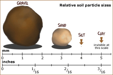
As the glaciers continued to move back-and-forth across the northern part of the continent, bedrock was eroded away. Rocks were crushed by the weight of the glacier into various sized pieces of sediment. Sand is sediment (rock minerals) defied by its size. As the image above illustrates, it is smaller than a piece of gravel, but much larger than a piece of silt.
Day after day, over the next 3,500 years, waves via the longshore current, deposited sand upon the shorelines. As sand accumulates upon the shorelines, wind over 8-MPH, causes the lightest grains to move. On Mt. Baldy, three (3) different movement patterns can be observed under various wind conditions:
- Surface Creep – when individual grains of sand roll along in contact with the ground.

- Saltation – when grains of sand strike each other they bounce off each other. If a grain of sand is momentarily picked up by the wind and strikes another grain of sand, that grain of sand will bounce into another grain, setting off a small chain reaction of grain movement.
- Suspension – when the wind blows strong enough it can lift sand fully off the ground, depositing it elsewhere.
Coastal dunes that form upon shorelines appear first as small sand ridges parallel to the waterline. Once they have drifted far enough away from the shoreline and their windward side becomes blocked by younger ridges, vegetation like marram grasses and cottonwood trees start to grow their roots burying themselves deep within the sand, stabilizing the dune from any further windblown drifting. These types of shore-parallel dunes are called transverse dunes.
 While these transverse dunes can be fairly stable and allow for more mature forests to develop, they can be easily disrupted. A violent storm, loss of vegetation, changes in the lake level, or longshore currents can destabilize the dune. When this occurs, a bowl-shaped depression, called a blowout, forms on the windward side of the dune, called the stoss side. As winds blow off the lake, the blowout extends in the direction of the wind, elongating it into a deep U-shape. This is called a parabolic dune. As these parabolic dunes move and grow, they cover existing landscapes, entire forests, houses, and even parking lots.
Parts of a Dune
A dune is a landform comprised of windblown sand.
The most basic dune requires three (3) things in order to form:
- An initial supply of sand to move into a dune.
- Wind strong enough to move the sand.
- A constant supply of sand for the dune to grow.
Dunes have a basic structure; see image above. Sand travels up the stoss slope, which is the windward side of the dune or the side of the dune facing the water. As sand reaches the apex or crest of the dune it begins to travel down the slipface or backside of the dune through a process called grainfall. You’ll be figuring out what magical angle this is at Stop 1 below. This angle is called the angle of repose. If we could crosscut the dune, you would see layers called foresets, which show this continual pattern of sand movement and dune growth over time. In a large rock or mountain, geologists would use the foresets to examine ancient environmental conditions over hundreds and thousands of years. Since Mt. Baldy moves and grows faster than a rock, these foresets would be measured in months, years, and even decades if we were able to cut the dune in half (1/2) to see them.
The historical case of Mt. Baldy
Around 200 years ago, Mt. Baldy looked drastically different. The transverse dunes which ran along the shorelines were covered with grasses, contained wildlife, and were crowned with a mature oak forest. Beginning in the mid-nineteenth century (1850s), significant changes in the shoreline, currents and sand deposition have altered the stability of the dune.
- Until the early twentieth century (1900s), the largest dune in the area, nicknamed Hoosier Slide, rose over 200 feet above the lake. However, the dune was quickly sold and mined for its mineral resources.
- The harbor in nearby Michigan City continued to grow and expand into the lake, altering the longshore current and changing the way sand was deposited ashore.
- As humans traversed the dune, climbing, sliding, and rolling, the deep roots of the grasses and trees were trampled; causing the vegetation to let its grip go, making the dune more susceptible to wind.
- The dune may have also been logged in the mid-nineteenth century, allowing more delicate dune grasses to re-grow in an area dominated by taller trees. This would have made it easier for humans to trample these grasses while traversing the dune.
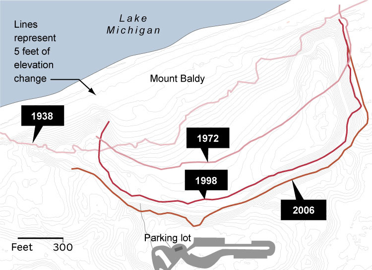
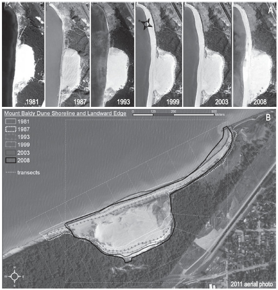
By comparing historical records with modern data, we can see Mt. Baldy has moved about 820 feet (.15/mi) since 1939. The data also shows that the shoreline itself has also drifted about 500 feet further inland across the entire southern shoreline. The rate at which Mt. Baldy drifts is entirely dependent on the strength of the wind. Mt. Baldy moves fastest in response to the late fall and winter storms that move swiftly across the lake. These harsh winter storms produce the largest waves, which carry away for more sand than they bring ashore. Ice shelves, which normally form along the shoreline during the cold of winter, help protect the sandy shoreline from erosion. However, warmer winters in recent history have been producing fewer and smaller ice shelves, causing the shoreline to erode faster.

The image is a map drawn in 1862 showing the relatively straight shoreline around the area of Mt. Baldy. Since then, Mt. Baldy has continued to drift in a southeastern direction; the direction the dominant winds direct it.
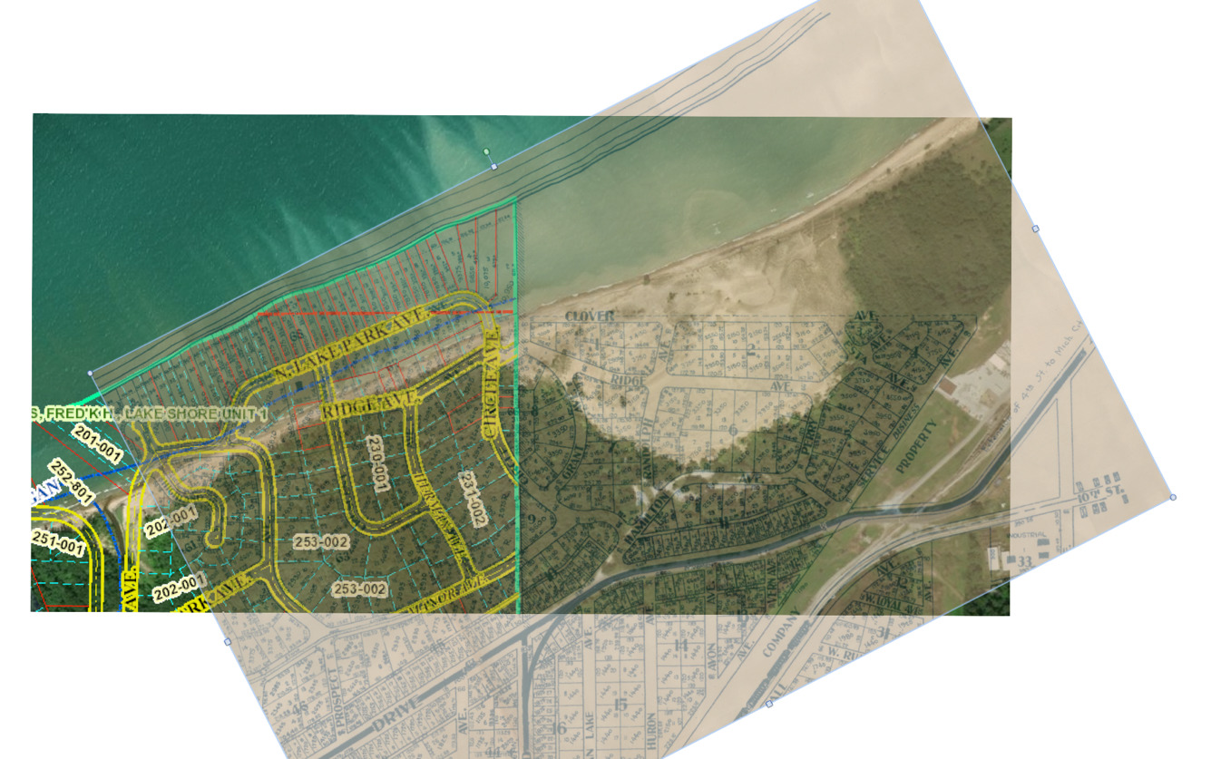
The image is an overlay of a map drawn in 1933 of the shorelines around Mt. Baldy and an aerial image of Mt. Baldy. Notice how far inland the lake has moved. Since 1938, Mt. Baldy has moved drastically, at a pace between four (4) and ten-(10) feet a year.
These images below show the changes in Mt. Baldy over the last 90 years.
Two dunes in one?
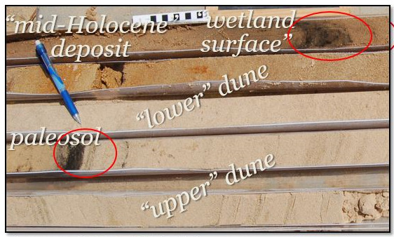
As the vegetation thinned and Mt. Baldy began to drift, the rich loam, or soil that was established atop the dune 3,500 years ago got covered with layers of modern sand. Oak trees that stood here for generations slowly got covered as the sand drifted southeast. Today, you can see that layer of old soil, called paleosol, mid-way up the dune when looking at it from the beach.
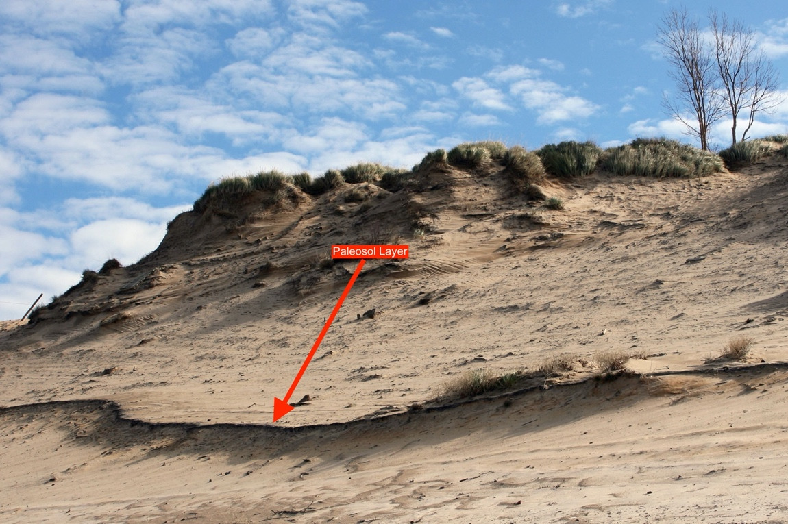
From that line and up the dune we can see old oak trees form a ghost forest buried by the newer, younger dune we know today as Mt. Baldy. Core samples taken from various points throughout the sloss side of the dune conclude the same results; that Mt. Baldy is a new dune, formed atop an older dune.
Park Information
(As of Spring 2020)
- The park is open from 6am-11pm Central Time
- Pets are allowed on the beach and trails within this geocache. Pets must always be on a leash no longer than 6-feet. Please pick up after your pet
- Please help protect our plants and wildlife by staying on the designated trails
- Visitor Center is located at 1215 N. State Road 49, Chesterton, IN 46304 – (219) 395-1882
- Have fun and CITO (Cache-in, Trash-out) your way through the park
Trail Maps
Mt. Baldy Trail Map