Welcome to the
Indiana Dunes National Park
This earthcache is all about looking at, feeling, and listening to -- sand. It takes place at four (4) locations throughout the National Park. You will need adequate transportation to take you between locations. In addition to transportation, you will need some tools of the trade (TOTTs): one (1) magnifying glass, one (1) rare earth magnet, one (1) 20oz. bottle of water (for doing experiments), and something to read elevation (GPSr/smartphone). Please note: This entire cache should take approx. one – two (1-2) hours to complete. See below for more information on the Indiana Dunes National Park.
Lake Michigan is the 3rd largest Great Lake and the 5th largest lake in the world by surface area (22,000 sq. mi). 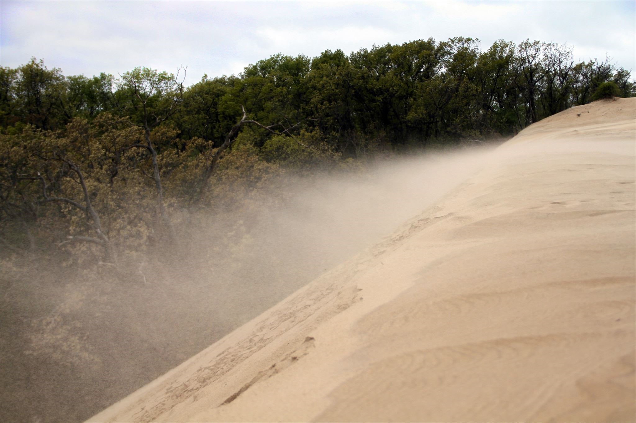 Fun fact: Lake Michigan is the largest lake in the world solely in one country. The shorelines that embody the Indiana Dunes National Park are in a state of constant change. All the sand you see is a 14,000 year old byproduct of glaciation and erosion, a process which continues today.
Have you ever heard that sand can sing? Some sand can belt out one single musical note, while others a range of musical notes. Singing sand is a phenomenon that happens on certain shorelines and desert dunes around the world. For this marvel to occur, sand must have the perfect conditions to resonate a sound. This EarthCache is going to explore some of the properties of sand at the Indiana Dunes National Park to see if we can uncover how sand within the landscape has changed over the past 14,000 years and how it resonates a tone like no other. So, let's put on our musical hats and grab our science kits and try to make the dunes sing!
A bit of geological history
The last continental glacial advancement, a period called the Late Wisconsin Glacial Episode, began around 50,000 years ago. During this time a large lobe of ice from the Laurentide Ice Sheet, drifted south across the landscape that would become the area surrounding modern Lake Michigan. Some years advancing across the landscape, other years retreating, but always grinding down bedrock exposed by previous glacial advancements and retreats. The advancement and retreat movements of the glacier scoured the earth, carving vast depressions within the earth, forming what would become the Great Lakes. As the glaciers began their final retreat northward about 14,000 years ago, ice melted away; the runoff gathering in the depressions carved by the glacier. Any debris that was gathered at the advancing edge of the glacier was deposited, forming a wall of sand, pebbles, rocks, and boulders several hundred feet high. These are called moraines. Terminal moraines like the Valparaiso Moraine located about 15 miles south of here mark the early shorelines of the ancient lake. These moraines acted as a wall for glacial water, trapping the water in the beds carved by the glacier. Waves brought sand ashore much like today forming the early Glenwood Beach Shorelines.
Over time, weak spots appeared in these moraines and lake borders. Ice continued to retreat, opening new ways for water to flow more easily. Water emptied out, rapidly lowering the lake level in some cases, and moving the shoreline further north. Sand dunes that had formed along these shorelines continue to evolve into ecologically into oak-hickory woodlands through a process called succession.
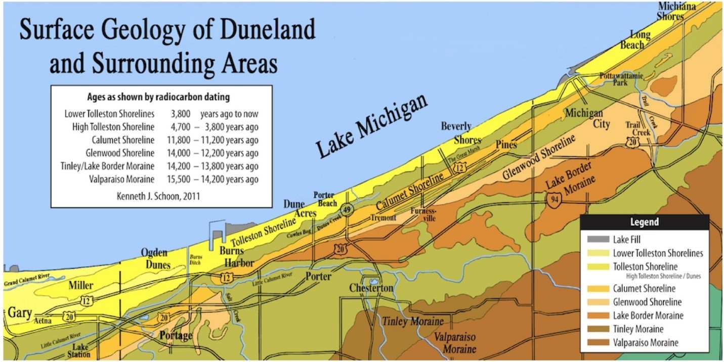
The Indiana Dunes National Park contains at least 4 prominent ancient shorelines: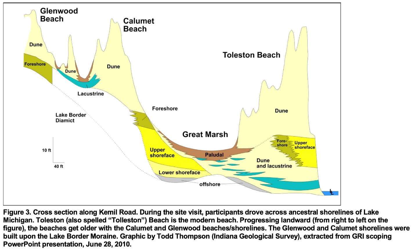
- Glenwood Shoreline
- Oldest shoreline, 14,000-12,200 years ago
- First formed when melted glacial water became trapped between moraines and the still-frozen glacier.
- Southern most shoreline, furthest from the modern beach
- Ended when the glacier advanced far enough north to uncover channels that allowed the trapped water a place to flow.
- Calumet Shoreline
- 11,800-11,200 years ago
- Formed when the glacier advanced far enough south to close the gap that ended the Glenwood Shoreline era
- Ended when the glacier retreated northward and opened a channel to the St. Lawrence Seaway.
- The level dropped around 100 feet lower in elevation than today, making the shoreline about 5 miles north of today’s beach.
- Tolleston Shoreline
- 4,700-3,800 years ago
- Between the end of the Calumet Shoreline and the beginning of the Tolleston Shoreline the lake level fluctuated rapidly, and often.
- Around 5,000 years ago the lake level stabilized forming the High Tolleston Shoreline.
- Modern Lower Tolleston Shoreline
- 3,800-present
- Formed when lake levels fell rapidly.
- This is the modern-day shoreline.
Lake to sand distribution
 The sand dunes forming today along the shoreline receive their sand supply entirely from wind and wave action and a current called the longshore current. As wind whips across the lake it generates waves. The waves stir sand and sediment from the bottom of the lake and slowly erode each grain into a semi-spherical shape. When waves collide with the beach, the energy causes sand along the shore to become dislodged, mixing with whatever debris and sediment the wave carried in. As the wave slowly drifts back toward the lake, some of the sand is left ashore, continuing to rebuild the beach each impact erodes away. Generally, beaches are built up during the summer and eroded away during the winter.
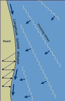
Longshore Currents
Waves around this portion of the lake, often generated by a northwest wind, typically to travel north-to-south, and east-to-west. When they strike the coast, they do not do so head-on. Instead they encounter the shore at different times, forming a wavy-shaped coastline. When these waves crash against the shore, they release their energy. Due to the wavy shape of the coastline, the rebounding energy from the wave heads back into the lake, forming a current called the longshore current. These longshore currents travel parallel to the shore in a southward direction, bringing with it any sand and sediment waves have disturbed from the shoreline or lakebed. All of these are contributing factors as to how and why dunes form where and why they do.
The sands of time
Sand throughout the southern shoreline range in size from very fine (1/16thmm) to very coarse (>1mm). About 90% of the sand is comprised of the mineral quartz. Also present are various feldspars (common minerals that make up about 41% of the Earth’s crust by weight). Trace amounts of other minerals like augite, hornblende, garnet, magnetite, zircon, and iron ores are also found.
The sand itself can range in color depending on your location on the shoreline thanks to the longshore current’s sand distribution. Typically, the sand ranges in color from a light brownish-yellow to an almost white. The darker the color indicates the sand has a higher heavy-mineral composition while the lighter color indicates lightly colored minerals like quartz.
The sand that was washed ashore by the lake and the sand picked up and blown by the wind to build a dune are very different. Waves generate immense power and can stir up the heaviest of sediment and debris to bring ashore. Conversely, wind can only pick up the lightest materials. This means sand found within the dune typically contains fewer heavy minerals than sand found closer to the waterline.
Singing Sand
Why does some sand sing and others don’t? It is believed that it comes down to a few contributing factors. The shape of the sand must be round enough to rub freely against another particle. Because of the high quartz concentration in this sand when these crystals rub, they resonate with a certain frequency. There also must be a perfect concentration of humidity. Just enough water to coat the grains of sand with a thin film to make them slippery enough to move freely. Have you been to any other beaches with singing sand? Let us know when you send your answers.
To Log This Cache…
Please do not post any answers in your log.
Message us with your answers and observations to the following questions:
Got your answers all submitted? Don't wait to log the cache, we'll reply back to you should you need help with an answer or two.
Taking what we have learned about the southern shorelines of Lake Michigan, let’s examine how sand has been distributed among the ancient beaches and see how the shoreline of Lake Michigan has changed over the last 14,000 years.
You will need a couple tools of the trade (TOTTs) in order to complete the mission.
- magnifying glass - you'll use this to make observations of the color, shape, and size of the sand.
- magnet - you'll use this to see if there are any heavy mineral or iron ores (magnetite or ilmentie) present.
- 20 oz. bottle of water - you'll use this to measure how long it takes the water to drain through the sand.
- GPS or smartphone - you'll need this to measure elevation changes.
At each waypoint perform the following:
- Using your magnifying glass pick up a small amount of ground, how coarse or fine are the sand particles? What colors do you see?
- How does it appear the sand reached this location? Was it by wind, water-wave action, glacial debris, or something else?
- Grab a small handful of sand, thin the layer and run your magnet slowly across the surface, just grazing the grains. Was anything attracted to your magnet?
- Do you think the presence of heavy minerals changed over time and distance away from the shoreline?
- Find a level spot (please stay on trails)
- Pour about 4oz of water in the ground. As the water seeps into the ground, count out long it takes to disappear. How long did it take?
- What does that tell you about the ground? Is it hard or soft? Why? How has it changed since the last waypoint?
- Elevation
- Record an elevation reading. How has the elevation changed from each location? What does that tell you about the age of each shoreline?
- Singing Sand Exercise: At the Beach Waypoint Only
- Let's take a moment to listen to the sand.
- Find a good stretch of beach about 10-50 feet away from the wave-wash waterline. Walk in a straight line using slightly dragging your feet through the sand.
- Does it sing when you walk? Describe the sound it is or is not making as you put your weight into it. Is the sand very wet or dry in this location?
- If you are having trouble, check out this video to see a demonstration. Click here.
Park Information
(As of Spring 2020)
- The park is open from 6am-11pm Central Time
- Pets are allowed on the beach and trails within this geocache except for the Glenwood Dunes Trail (final waypoint). Pets must always be on a leash no longer than 6-feet. Please pick up after your pet.
- Please help protect our wildlife and stay on the designated trails
- Visitor Center is located at 1215 N. State Road 49, Chesterton, IN 46304 – (219) 395-1882
Trail Maps
Click the links below
- Kemil beach and Dune Ridge Trail
- Calumet Dunes Trail
- Glenwood Dunes Trail
|
|
Congrats to
sgerbs
for being FTF! |