[04] Les pavés de la rue Nationale
par ipln | GC8M8ER | Tours

► Le parcours [Géol' Tours] ◄
Tours est une métropole située au cœur du Val de Loire, classé patrimoine mondial UNESCO.
Depuis la fondation de la cité romaine de Caesarodunum, la ville s'est développée sous l'influence du cours du fleuve et des richesses du sous-sol de la Touraine. Ses maisons, édifices religieux, châteaux ou ponts sont issus des pierres extraites dans la région.
Le parcours [Géol' Tours] vous propose une série de EarthCaches décrivant des natures de roches, des phénomènes géologiques ou hydrologiques, afin de découvrir cette richesse géologique sur les rives de la Loire et dans les rues de la ville.
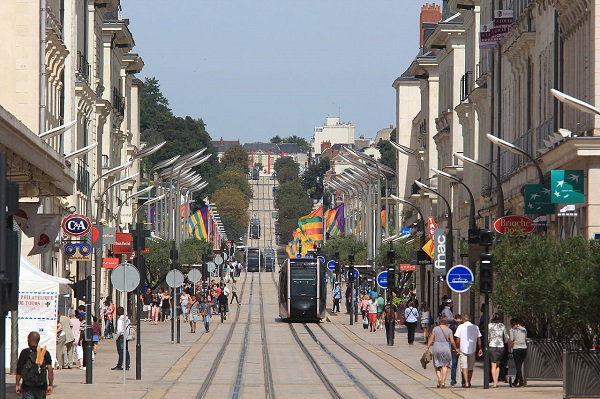
► Partie 1 : La Rue Nationale ◄
Anciennement Rue Royale, elle fut percée en 1777. Ce projet fit basculer l'axe de la ville : anciennement orienté est-ouest avec les rues du Commerce et Colbert, il devint alors nord-sud entre la Place Anatole France (où débouche le Pont Wilson) et la Place Jean Jaurès avec l'Hôtel de Ville (d'où débute l'Avenue de Grammont).
Cette partie de la ville fut largement détruite par les bombardements lors de la Seconde Guerre Mondiale : il reste peu de choses des matériaux utilisés traditionnellement pour la construction dans la ville de Tours (bois, brique, calcaire lacustre, et surtout tuffeaux). Seule l'église Saint-Julien fut épargnée. Des pierres calcaires claires (principalement du calcaire oolithique de Chauvigny) furent utilisées pour la reconstruction des bâtiments lors des années 1945-1950 en raison de leur ressemblance avec le tuffeau turonien.
La Rue Nationale devint piétonne en 2013 avec l'implantation du tramway. La rue fut alors entièrement pavée avec des calcaires marins mésozoïques issus de diverses carrières françaises. Pour cette EarthCache, nous allons nous intéresser à certaines caractéristiques de ces pierres calcaires.
► Partie 2 : Les pavés calcaires ◄
► Origines marines :
Les pierres calcaires de la Rue Nationale sont issues de carrières situées en France et formées dans la mer à différentes périodes de l'ère Mésozoïque (Secondaire). Ces pierres sont des calcaires de grain fin et déposés dans des mers calmes :
Bourgogne : Calcaires du Bajocien (-176 Ma) et du Bathonien (-167 Ma)
Lozère : Calcaire du Bathonien (-167 Ma)
Jura : Calcaire du Valanginien (-130 Ma)
Domaine continental et marin au Jurassique Moyen et Supérieur.
Ces différentes pierres forment un patchwork de teintes grises, beiges, ocres et rousses. Toutefois, il est difficile de préciser l'origine de chacune des roches car bien que d'origines différentes, leurs aspects sont très proches. De plus, au sein d'une même carrière, la teinte peut également varier.
Une observation attentive permet de mettre en évidence leurs origines marines.
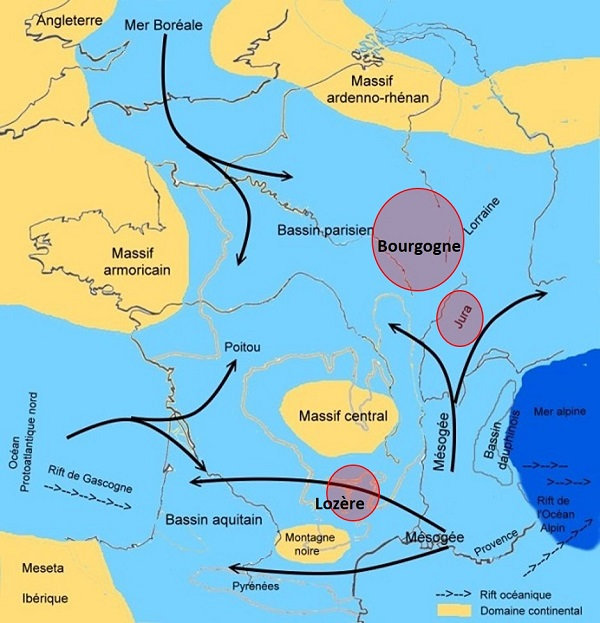
► Fossiles de mollusques et coraux :
(a) et (b) Des traces blanchâtres et grisâtres incurvées : des fragments de coquilles fossiles de mollusques marins, en coupes transversales et remplies de cristaux de calcite ;
(c) Des formes rondes à ovales avec des nervures radiales partant du centre : des squelettes sécrétés par des polypes solitaires (corail), faisant partie de l'embranchement des cnidaires.
► Ichnofossiles :

(d) Des formes circulaires ou semi-circulaires, se recoupant et/ou recoupant des bandes plus claires : des traces fossilisées d'anciens terriers ;
(e) des formes allongées ovales "en doigts" jaunâtres ou rouilles : d'autres traces d'anciens terriers de crustacés.
Il s'agit d'habitats creusés par des animaux marins, souvent des crustacés de type langoustine par exemple, dans la boue au fond de la mer. On parle alors d'ichnofossiles : des traces d'activité biologique qui ont été fossilisées. Outre les terriers observables Rue Nationale, les ichnofossiles peuvent consister en des pistes trahissant des déplacements d'animaux, des traces de forages mécaniques ou biochimiques, des œufs, voire même des déjections.
► Fossiles d'oncolithes :

(f) des nodules de formes circulaires à ovales, entourés de couches concentriques : ce sont des concrétions calcaires d'origine marine appelées oncolithes (taille centimétrique) de la famille des stromatolithes.
► Fractures :
Les contraintes subies par les roches peuvent également être observées :
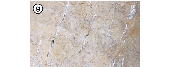
(g) des stries parallèles en échelon, blanches : fractures dues aux contraintes subies par la roche, et remplies de calcite. L'orientation des stries permet de déduire les mouvements de contraintes (plus d'explications dans GC99DR3).
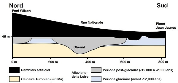
► Partie 3 : Une rue en pente ? ◄
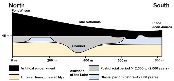
Depuis l'extrémité sud du Pont Wilson, la Rue Nationale descend sensiblement vers le sud. Cette pente n'est pas naturelle : elle est due à des remblais artificiels. Au fil du temps depuis l'époque romaine, les habitants ont déposé des matériaux (terres, roches, restes de pierres de construction) près du fleuve pour deux raisons : (1) gagner de l'espace urbanisé vers le nord au détriment du fleuve, et (2) se prémunir contre les crues en surélevant cet espace.
Le substrat rocheux, du calcaire Turonien, se retrouve ainsi plusieurs mètres en-dessous du niveau du sol. Ce substrat est recouvert par des alluvions de la Loire. Il est à noter qu'un ancien chenal, encore fonctionnel à l'époque romaine, était orienté est-ouest. Il fut progressivement comblé par sédimentation des alluvions du fleuve.
Pour loguer cette EarthCache, rendez-vous aux différents Waypoints situés dans la Rue Nationale, et répondez aux questions suivantes.
0 ► Joignez à votre log une photographie permettant de vous identifier (visage, GPS, pseudo, etc.) dans la Rue Nationale.
1 ► Rendez-vous aux Waypoints 1 puis 6 :
1a. Relevez votre altitude à l'extrémité nord de la Rue Nationale (Waypoint 1), puis à l'extrémité sud (Waypoint 6).
1b. Déterminez le dénivelé de la rue.
1c. Déduisez la hauteur maximale du remblais au Waypoint 1.
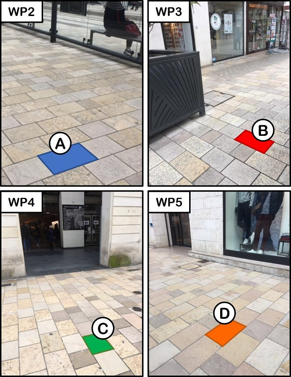
2 ► A partir des description des calcaires :
2a. Observez les pavés des photographies ci-dessous, et décrivez les caractéristiques de chacun: A (Waypoint 2), B (Waypoint 3), C (Waypoint 4), et D (Waypoint 5).
2b. Expliquez comment ces caractéristiques se sont formées.
Rappels concernant les « EarthCaches » :
Il n’y a pas de contenant à rechercher aux coordonnées, ni de carnet à signer sur place. Il suffit de se rendre sur les lieux, de répondre aux questions ci-dessus, et de nous envoyer vos propositions de réponse soit via notre profil, soit la messagerie geocaching.com (Message Center).
Vous pouvez loguer un « Found it » sans attendre notre confirmation. Nous vous contacterons en cas de problème ou pour fournir d’éventuelles précisions.
Les « Found it » enregistrés sans envoi de réponses seront supprimés.

► [Géol' Tours] ◄
Tours is a metropolis located in the heart of the Loire Valley, classified as World Heritage by UNESCO.
Since the foundation of the Roman city of Caesarodunum, Tours has grown under the influence of the Loire and the riches of the Touraine basement. Its houses, religious buildings, castles or bridges come from stones extracted in the region.
[Géol' Tours] offers a series of EarthCaches describing rock natures, geological or hydrological phenomena, in order to discover the geological richness on the banks of the Loire and in the streets of the city.
► Part 1: Rue Nationale ◄
Formerly Rue Royale, it was pierced in 1777. This project changed the axis of the city: formerly oriented east-west with the streets of Commerce and Colbert, it then became north-south between Place Anatole France (where the Wilson bridge opens) and Place Jean Jaurès with the Town Hall (and from where the Avenue de Grammont begins).
This part of the city was largely destroyed by bombing during the Second World War: little remains of the materials traditionally used for construction in the city of Tours (wood, brick, lacustrine limestone, and above all tufa). Only the Saint-Julien church was spared. Clear limestone (mainly oolitic limestone of Chauvigny) was used for the reconstruction of the buildings during the years 1945-1950 because of their resemblance to the Tuffeau Turonian.
Rue Nationale became pedestrian in 2013 with the establishment of the tram. The street was then entirely paved with Mesozoic marine limestones from various French quarries. For this EarthCache, we will focus on certain characteristics of these limestones.
► Part 2: The limestone pavements ◄
► Marine origins:
The limestones of the Rue Nationale come from quarries located in France, and formed in the sea at different periods of the Mesozoic era (Secondary). These stones are fine grain limestones and deposited in calm seas:
Burgundy: Bajocian (-176 My) and Bathonian limestones (-167 My)
Lozère: Bathonian limestone (-167 My)
Jura: Valanginian limestone (-130 My)
Continental and marine area in the Middle and Upper Jurassic.
These different stones form a patchwork of gray, beige, ocher and red tones. However, it is difficult to specify the origin of each of the rocks because lbien of different origins, their aspects are very close. In addition, within the same career, the shade can also vary.
Careful observation highlights their marine origins.
► Fossils of molluscs and corals:

(a) and (b) Curved whitish traces: fragments of fossilized shells of mollusks, with calcite;
(c) Round to oval shapes with radial ribs starting from the center: skeletons secreted by solitary polyps (coral), part of the cnidarians family.
► Ichnofossils:
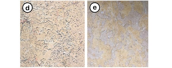
(d) Circular or semi-circular shapes, intersecting lighter bands: fossilized traces of old burrows;
(e) elongated oval, yellowish or rusty forms: other traces of old crustacean burrows.
These are habitats dug by marine animals, often by crustaceans such as lobsters, in the mud at the bottom of the sea. These are said ichnofossils: traces of biological activity that have been fossilized. In addition to the burrows observable on Rue Nationale, ichnofossils can consist of tracks betraying animal movements, traces of mechanical or biochemical drilling, eggs, or even animal excrement.
► Fossils of oncoliths:
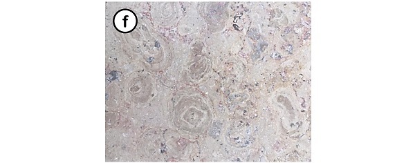
(f) Nodules of circular to oval shapes, surrounded by concentric calcite layers: these are calcareous of marine origin called oncoliths (centimeter size) of the stromatolith family.
► Stresses:
The stresses experienced by the rocks can also be observed:

(g) White, ribbed parallel streaks: fractures due to stresses on the rock, and filled with calcite. The orientation of the streaks makes it possible to deduce the stress movements (more explanations in GC99DR3).
► Part 3: A sloping street? ◄
From the south end of the Wilson bridge, Rue Nationale descends significantly to the south. This slope is not natural: it is due to artificial embankments. Over time since the Roman era, the inhabitants deposited materials (earth, rocks, remains of building stones) near the river for two reasons: (1) to gain some urbanized space towards the north , and (2) protect themselves against floods by raising this space.
The substrate, Turonian limestone, is thus found several meters below ground level. This substrate is covered by alluvium from the Loire. It should be noted that an old channel, still functional during the Roman era, was oriented east-west. It was gradually filled by sedimentation of the river alluvium.
To log this EarthCache, go to the Waypoints located on the Rue Nationale, and answer the following questions.
0 ► Join to your log a photo that identifies you (face, GPS, nickname, etc.) in the Rue Nationale.
1 ► Go to the Waypoints 1 and then 6:
1a. Read your altitude at the north end of Rue Nationale (Waypoint 1), then at the south end (Waypoint 6).
1b. Determine the elevation of the street.
1c. Deduct the maximum height of the embankment at Waypoint 1.
2 ► Thanks to the descriptions of the limestones:
2a. Observe the stones of the photos below, and describe the characteristics of each: A (Waypoint 2), B (Waypoint 3), C (Waypoint 4), and D (Waypoint 5).
2b. Explain how these characteristics were formed.
Reminders about the “EarthCaches”:
There is no container to look for nor a logbook to sign. Just go to the location, answer the questions above, and send us your proposals of answers either via our profile or Message Center.
You can log “Found it” without waiting for our validation. We will contact you in case of problems or to provide any clarification.
“Found it” logs saved without sending answers will be deleted.
Source :
MACAIRE J.-J. 2015 - Promenade géologique à Tours. Biotope, Mèze - MNHN, Paris (Collection Balades géologiques), 38 pages.
Quand vous aurez trouvé les 14 EarthCaches de la série [Géol' Tours], vous pourrez afficher cette bannière sur votre profil.
When you have found the 14 EarthCaches of the series [Géol' Tours], you can display this banner on your profile page.

Code
<center><a href="https://coord.info/GC8H33V" target="_blank"><img src="https://s3.amazonaws.com/gs-geo-images/91aa1d19-52eb-48e4-bcaa-30553b8f03d9.jpg" /></a></center>