
Les trous du causse
Situation géographique
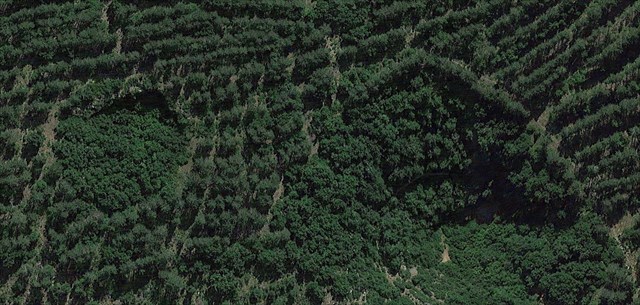
Les régions karstiques des Cévennes sont réputées pour être un véritable gruyère. On y trouve de noumbreuses formations géologiques (karst, lapiaz, diaclase, grotte, aven, doline, chaos, ...)
Nous allons ici nous intéresser à 2 types de formation géologique remarquable et avoir la possibilité de les observer sur le même terrain.
Géologie
Aven
Un aven est un terme qui vient de l'occitan pour définir un abîme (ou un gouffre). Cette dénomination n'est presque utilisée que dans le massif central.
Les abîmes se forment de la même façon que les grottes. Principalement par l'érosion due à l'eau. Contrairement aux grottes où l'eau circule de façon horizontale, dans les abîmes, elle s'enfonce dans la terre. Ce qui a pour conséquence de créer une ouverture dans le sol avec une forte verticalité.
La taille des avens peuvent être très variable, de quelques centimètres à quelques centaines de mètres. Leur profondeur peut aussi beaucoup varier.
L'eau s'infiltre dans la roche perméable (ici, du calcaire) et descend jusqu'à rencontrer une couche imperméable. Ensuite, elle peut creuser la roche horizontalement, ce qui crée une cavité au fond de l'aven.
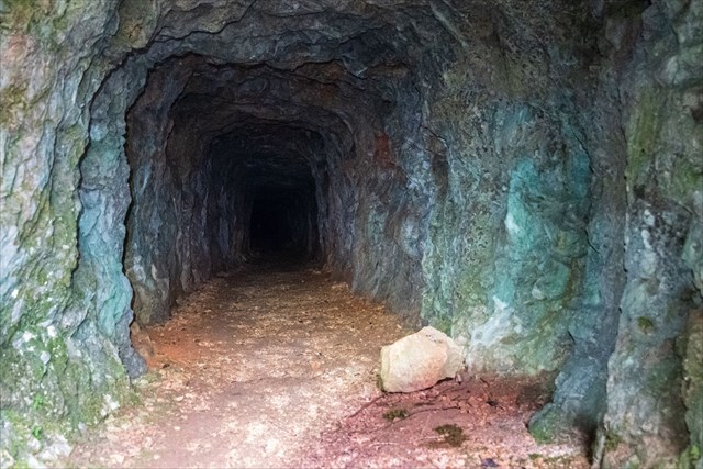
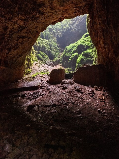
Ici, l'aven a une profondeur d'environ 70 mètres. Il est prolongé par une cavité facilement accessible par un tunnel créé par l'homme pour l'exploitation du site (voir plus bas "histoire du site").
Doline
Les dolines sont généralement créées par un effondrement de la couche superficielle d'une cavité créée par l'érosion d'une rivière sous-terraines.
De ce fait, on se retrouve souvent avec un trou de quelques mètres à quelques centaines de mètres dont le sol est constitué d'argiles alors que les terrains alentours sont karstiques (calcaire).
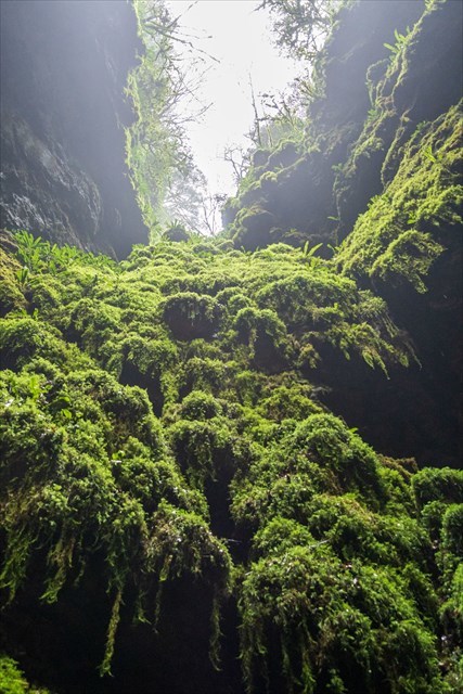
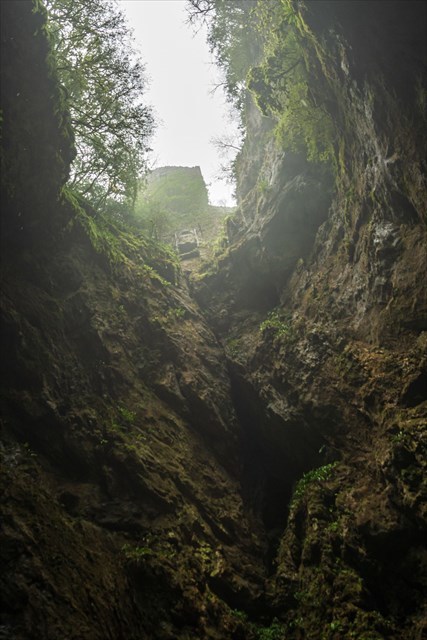
Il en résulte un microcosme avec un micro-climat, une faune et une flore qui peuvent être bien différents de ceux autour.
Dans les dolines présentes sur le site, vous pouvez voir une végétation luxuriante, alors que le terrain est principalement constitué de pins éparses. Il est aussi possible de voir une brume monter du fond des dolines.
Histoire du site
(sans rapport avec la earth-cache)
Le site a été utilisé pour faire du fromage (Roquefort) au fond de la grotte.
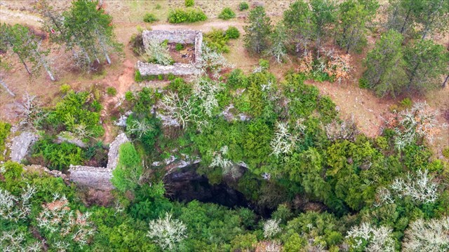
En 1882, un batiment est construit au bord de l'aven (toujours présent sur le site). Dans ce batiment, un treuil permettait de descendre et monter de l'abîme.
Un peu plus tard, une galerie fut creusée en pente douce entre une des dolines et la grotte de façon à pouvoir descendre et monter les fromages par wagonnets.
La production de fromage a duré de 1882 à 1929 et a peut-être été stoppée par le classement en AOP du Roquefort en 1925 (le site étant en dehors de la zone admise).
L'aspect le plus remarquable du site est qu'il était un bagne pour enfants. Le bagne a ouvert en 1856. Les enfants y faisaient des travaux agricoles pour les plus jeunes, et des travaux de déblaiements, de constructions et autres par les plus agés (à partir de 13 ans).
Certaines sources stipulent que la galerie aurait été creusé par les enfants avec des pics dans une roche particulièrement dure.
Sur le site, on trouve aussi le cimetière du camp. A total, il y a eu 70 morts. Malheureusement, le cimetière est en très mauvais état.
Pour en savoir plus, c'est par ici.
Sources
Pour la création de cette earth-cache, j'ai utilisé différentes sources dont les principales sont Wikipedia et geopole12.org.
Pour valider la cache
-- Conformément aux guidelines de Groundspeak --
Envoyez-moi vos propositions de réponses soit via mon profil, soit via la messagerie geocaching (Message Center), PUIS loguez cette cache 'Found it'. Je vous contacterai en cas de problème.
Vu le nombre de logs que je reçois sans message, tout log posté sans avoir envoyé les réponses aux questions sera supprimé sans avertissement.
N'importe où :
1. Expliquez avec vos mots la différence entre un aven et une doline.
Au point Q1 (Question Aven) :
2. Avec votre GPS, mesurez la largeur de l'aven (distance entre le Q1 et l'espace d'herbe en face) ?
Au point Q2 (Questions Doline 1) :
3. Avec votre GPS, mesurez le diamètre de la doline (distance entre le Q1 et l'espace d'herbe en face) ?
4. Trouvez une roche cassée ou cassez-en une. Décrivez ce que vous voyez (aspect, couleur, dureté). Déduisez de quelle type de roche il s'agit (magmatique, sédimentaire ou métamorphique) ?
Au point Q3 (Questions Doline 2) :
Entrez dans le tunnel, allez dans la grotte, puis montez sous l'aven. Vous devez voir le ciel.
5. Décrivez le sol au fond de l'aven (couleur, texture). Expliquer pourquoi avec vos mots.
6. Prenez une photo au fond de l'aven. La photo est à inclure au log.
|
Consignes Supplémentaires
- Ne vous approchez pas du bord de l'aven. Il y a environ 70m de vide.
- Vous êtes sur une propriété privée. Le propriétaire autorise l'accès à la grotte. Soyez respectueux des lieux.
- Portez de bonnes chaussures.
- Une lampe est nécessaire pour traverser le tunnel.
|

Causse holes
Geographic location
The karst regions of the Cévennes are renowned for being a real Swiss cheese. There are numerous geological formations (karst, lapiaz, deaclase, cave, aven, sinkhole, chaos, ...)
Here we will focus on 2 types of remarkable geological formation and have the opportunity to observe them on the same terrain.
Geology
Aven
An aven is a term that comes from Occitan to define an abyss (or an abyss). This designation is almost used only in the central massif.
The abyss is formed in the same way as the caves. Mainly by water erosion. Unlike caves where water circulates horizontally, in the abyss, it sinks into the earth. This has the effect of creating an opening in the ground with a strong verticality.
The size of the abyss can be very variable, from a few centimeters to a few hundred meters. Their depth can also vary greatly.
The water infiltrates into the permeable rock (here, limestone) and descends until it meets an impermeable layer. Then, it can dig the rock horizontally, which creates a cavity at the bottom of the pit.
Here, the pit has a depth of about 70 meters. It is extended by a cavity easily accessible by a human-made tunnel for the operation of the site (see below "history of the site").
Doline
Dolines are generally created by a collapse of the surface layer of a cavity created by the erosion of a subterranean river.
As a result, we often end up with a hole of a few meters to a few hundred meters, the soil of which is made up of clay, while the surrounding terrain is karst (limestone).
The result is a microcosm with a micro-climate, a fauna and a flora which can be very different from those around.
In the dolines on the site, you can see lush vegetation, while the terrain is mainly made up of scattered pines. It is also possible to see a mist rising from the bottom of the sinkholes.
History of the site
(not related to earth-cache)
The site was used to make cheese (Roquefort) at the bottom of the cave.
In 1882, a building was built on the edge of the abyss (still present on the site). In this building, a winch made it possible to descend and ascend from the abyss.
A little later, a gallery was dug in a gentle slope between one of the dolines and the cave so as to be able to descend and ascend the cheeses by wagons.
The production of cheese lasted from 1882 to 1929 and was perhaps stopped by the classification in AOP of the Roquefort in 1925 (the site being outside the admitted zone).
The most remarkable aspect of the site is that it was a penal colony for children. The penal colony opened in 1856. The children there did agricultural work for the youngest, and excavation, construction and other work by the oldest (from 13 years old).
Some sources state that the gallery was dug by children with peaks in a particularly hard rock.
On the site, there is also the camp cemetery. A total of 70 people were killed. Unfortunately, the cemetery is in very poor condition.
To find out more, it's there. (in French)
Sources
For the creation of this earth-cache, I used different sources, the main ones are Wikipedia and geopole12.org.
To validate the cache
-- In accordance with Groundspeak guidelines --
Send me your suggested answers via my profile either via messaging geocaching (Message Center), THEN log this cache 'Found it'. I will contact you in case of problems.
Given the number of logs I receive without a message, any log posted without having sent the answers to the questions will be deleted without warning.
Anywhere:
1. Explain in your words the difference between an abyss and a sinkhole.
In point Q1 (Abyss Question):
2. With your GPS, measure the width of the abyss (distance between the Q1 and the opposite grass space)?
In point Q2 (Sinkhole 1 Questions):
3. With your GPS, measure the diameter of the sinkhole (distance between Q1 and the opposite grass space)?
4. Find a broken rock or break one. Describe what you see (appearance, color, hardness). Deduce what type of rock it is (magmatic, sedimentary or metamorphic)?
In point Q2 (Sinkhole 2 Questions):
Enter the tunnel, go into the cave, then climb under the abyss. You must see the sky.
5. Describe the ground at the bottom of the pit (color, texture). Explain why with your words.
6. Take a picture at the bottom of the abyss. The photo has to be included in the log.
|
Additional instructions
- Stay away from the edge of the abyss. There is approximately 70m of vacuum.
- You are on private property. The owner authorizes access to the cave. Be respectful of the place.
- Wear good shoes.
- A lamp is necessary to cross the tunnel.
|