Skip to content

Pias no castelo - Castle's rock basins EarthCache

Hidden : 12/4/2019
Difficulty:
2 out of 5
Terrain:
1.5 out of 5

Size: Size:   other (other)

Join now to view geocache location details. It's free!

Watch

How Geocaching Works

Please note Use of geocaching.com services is subject to the terms and conditions in our disclaimer.

Geocache Description:


Perguntas para responder - questions to answer

Para reclamar esta earthcache deverá enviar-me, através do meu perfil e antes de qualquer registo, as respostas às seguintes questões. Se algo estiver incorrecto será contactado. Não é necessário esperar por qualquer autorização. Por favor não envie fotografias. Essas são mais úteis no registo.

Nas coordenadas da earthcache, e de frente para a porta do castelo, deverá ver três pias na superfície do granito. Na dúvida consultar a foto spoiler.

1 - Qual é o diâmetro da pia da direita?

2 – Qual é o tipo da pia do meio segundo a classificação do texto? Explique porquê.

3 – A pia da esquerda tem um exutório (é por onde escorre a água), qual é a orientação do mesmo de acordo com uma bússola?

Obrigatório:

Uma foto por cada registo e a ser incluída no momento do mesmo. Ou claramente identificado no ponto zero com o castelo nas costas ou senão o desejar, uma foto na zona do ponto zero em que apareça o nick, a data da visita e um pé ao lado do buraco da direita. Por favor não revele as respostas com essa foto. Obrigado pela visita.

To claim this earthcache one should send me, through my profile and before any found log, the answers to the following questions. If something is incorrect I'll contact you. There is no need to wait for any authorization. Please do not send photos. These are more useful on the log.

At the earthcache coordinates you should see some weather pit on the granite surface when facing the castle's door..

1 - What is the estimated diameter of the rock basin on the rightside?

2 - Which is the central rock basin type accordingly the text classification? Explaine why.

3 - The lefthand side rock basin has an water exit, what is its orientation regarding North?

Mandatory:

A photo for each log to be included at the same time as the log. Or clearly identified (a selfie) at ground zero with the castle on your back or if you don’t wish a photo, at ground zero that shows your nickname, date of visit and a foot near the rightside pit. Please do not reveal the answers with this photo. Thank you for your visit.


A pia


A pia é uma manifestação da erosão na rocha e que usualmente se vê nos granitos. Estas formas têm várias designações consoante a origem em termos de idioma dos autores. Inglesa: rock basins, rock holes, weather pits, pot holes, water eyes, cauldrons, granite pits, gnammas, panholes, solution pans; Alemã: baumverfallspingen, dellen, verwitterungsnäpfe, opferkessel: Francesa: vasques rocheuses, Espanhola: pias e pilancones e Portuguesa (de ambos os lados do Atlântico): vascas, oriçangas, tanques, caldeiros, poços, marmitas e pias.

As pias ou oriçangas (vulgo os buracos) são pequenas depressões ou simples concavidades que se descobrem preferencialmente nos sectores horizontais ou pouco inclinados das superfícies rochosas. Por vezes podem aparecer nas paredes de alguns blocos, indicando um deslocamento do bloco posterior à formação da pia. Podem ainda desenvolver-se ao longo e na intersecção de fracturas ou descontinuidades, podendo, em alguns casos, alargar-se ao longo destes.

Estas formas têm a capacidade de reter por algum tempo água no seu interior e que desempenha um papel genético fundamental ao permitir a progressão da meteorização química no fundo e nas paredes das pias. A água é evacuada, quando em excesso, através dos bordos das pias ou por um canal preferencial, de altura inferior à parte restante do bordo.

Entretanto, a água que fica retida nestas concavidades acaba por desaparecer por evaporação provocada pelo sol ajudado pelo vento. É frequente encontrarmos no interior das pias produtos da desagregação física ou da alteração química, nomeadamente areias graníticas, bem como líquenes e musgos colonizando essencialmente as paredes.

As pias apresentam, fundamentalmente, formas circulares, ovóides ou elípticas. Podem igualmente, por influência da estrutura (diáclases e fracturas), ganhar contornos irregulares, ou por coalescência de duas ou mais pias, formas lobadas.

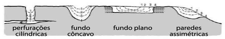
Segundo Twidale e outros autores existem quatro tipos principais de pias ou oriçangas em termos de morfologia.

  1. Pias de fundo côncavo (pits) – apresentam secção hemisférica e desenvolvem-se sobre superfícies suavemente inclinadas. Em muitos casos não têm exutório definido. Quando este existe é estreito;
  2. Pias de fundo plano (pans) – são em comparação com as anteriores, menos profundas, e têm o fundo plano. Habitualmente não têm exutório definido e o transbordo da água faz-se ao longo de todo o contorno da concavidade;
  3. Pias de paredes assimétricas (armchair-shape) – têm uma secção assimétrica segundo a linha de máximo declive. Na parte superior, as paredes da pia têm maior altura que na inferior, que é onde se encontra o exutório. Estas formas são típicas de superfície moderadamente inclinadas (20-30º);
  4. Perfurações cilíndricas (cylindrical hollows) – a sua forma em planta varia, ainda que em geral sejam circulares, com uma secção transversal rectangular. Em alguns casos o cilindro escavado na rocha termina numa fractura de descamação que pode permitir a drenagem da pia, o que evidentemente se produz num estádio final da sua evolução.

As pias a observar

Mais informação sobre o Castelo de Belmonte pode ser lida aqui e aqui.

Fontes:

CAMPBELL, E. M., TWIDALE, C. R. The Various origins of minor granite Landforms
VIEIRA, A. –Alguns aspectos da paisagem da Serra de Montemuro. Formas de pormenor de modelado granítico.
http://www.dct.uminho.pt/pnpg/enq_geol.html
http://pubs.usgs.gov/of/2008/1103/of2008-1103_pamphlet.pdf
http://keckgeology.org/files/pdf/symvol/14th/idaho/shopoff.pdf


The rock basin


The rock basin is a example of a granit weathering results.

These forms have several designations accordingly the author’s language origins. English rock basins, rock holes, weather pits, pot holes, water eyes, cauldrons, granite pits, gnammas, panholes, solution pans, rock basins; German: baumverfallspingen, dellen, verwitterungsnäpfe, opferkessel: French: vasques rocheuses, Spanish: pias e pilancones eand Portuguese (both sides of Atlantic): vascas, oriçangas, tanques, caldeiros, poços, marmitas e pias.

Rock basins are small depressions or mere concavities that one can see mainly at the horizontal sectors or with tiny slopes of rock surfaces. Sometimes they can be seen on block walls showing a later dislocation after the pit formation. They can also appear and develop along fractures and fracture intersections or discontinuities and can, in some cases, enlarge along these fractures.

These basins have the capability to retain, for some time, water on their interior. This water has a fundamental genetic role allowing chemical weathering progression on the basin bottom and basin walls. When there is a excess of water some is evacuated over the basin side walls edge or through a preferential channel with a height smaller than the other edge parts.

Meanwhile the remaining water retained in these holes will evaporate. This is caused by the Sun and wind effects. Frequently one could find in the basin interior granitic sands from the physical or chemical weathering as lichens and moss colonizing essentially the basin walls.

Rock basins have round, ovoid and elliptical shapes. Equally they can have irregular shapes caused by the structure which they are upon or by joining two or more rock basins which give a lobed form.

Twidale and other authors say that according their morphology they are 4 main basin types.

  1. Pits – they have hemispherical section and develop over surfaces with small slopes. Most of times there is not a defined exit. And when there is an exit it is narrow;
  2. Pans (or panholes) – they are, comparing with previous type, less shallow and have a flat bottom. Usually they don’t have a defined exit and the water flows over the basin edge;
  3. Armchair-shape – they have a asymmetrical section and along maximum slope. At the rock upper side walls are higher than those on the rock lower part. The water exit is on the lower part. These formations are typical at slopes whith moderate inclines (20-30º);
  4. Cylindrical hollows – even if their usual upper form is roundish sometimes they appear with other shapes. Their cross sections are rectangular. In some cases the rock drilled cylinder ends on to a sheeting slab and this allows the basin drainage.

The rock basins to be observed

More about Belmonte's castle can be read here.

References:

CAMPBELL, E. M., TWIDALE, C. R. The Various origins of minor granite Landforms
VIEIRA, A. –Alguns aspectos da paisagem da Serra de Montemuro. Formas de pormenor de modelado granítico.
http://www.dct.uminho.pt/pnpg/enq_geol.html
http://pubs.usgs.gov/of/2008/1103/of2008-1103_pamphlet.pdf
http://keckgeology.org/files/pdf/symvol/14th/idaho/shopoff.pdf


Por favor não partilhe as respostas. Para que continuem a existir earthcaches junte ao registo uma fotografia desse dia no ponto zero. Assim ajuda a acabar com as visitas fantasmas a lembrar o Walter Mitty.
Please do not share the answers. To make sure that earthcaches endure append to your log a photo of the day at ground zero. It helps to end ghost visits that resemble Walter Mitty.


Additional Hints (No hints available.)