|
Géologie
Fr :
Fz: Alluvions récentes : blocs, graviers, sables, limons et argiles tourbeuses (0 à 7 m) - Fin Pléistocène à Holocène
Fy2: Alluvions anciennes de basse terrasse (0 à 10 m) - Pléistocène
c2T :Tuffeaux blancs et jaunes : (0 à 80 m) - Turonien,moyen et supérieur.
c3V : Craie de Villedieu, partie inférieure (0 à 25 m) - Coniacien
Rc : Formation résiduelle à silex (2,5 m à 13,5 m). Altération au Crétacé terminal - Eocène inférieur
eS : Galets, sables, "perrons" et grès lustrés, argiles (0 à 15 m) - Eocène,inférieur.
eA : Argiles versicolores (9 m maximum) - Eocène inférieur
CeS-OE :Colluvions polygéniques de versan (0 à 2 m).
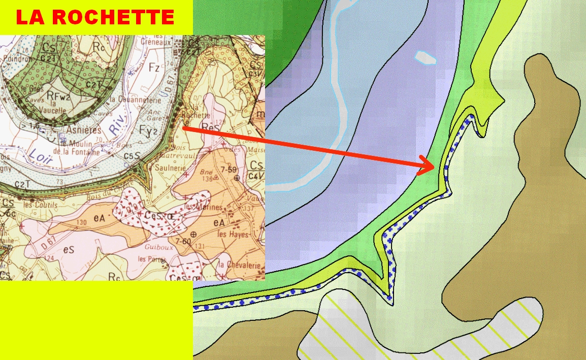
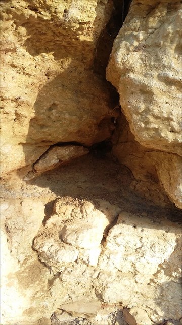
Le Tuffeau turonien (- 90 Ma )d'un mur d'escalade d'une centaine de mètres de long permet de voir le phénomène karstique souterrain.
En bas la cavité est au niveau du joint de stratification inférieur.
Les fractures verticales (Conduits karstiques voie d'escalade 69) et les joints de stratification ont permis la circulation des eaux d’infiltration et souterraines.
Le karst est une structure géomorphologique résultant de l'érosion hydrochimique et hydraulique de cette roche calcaire solubles, une roche carbonatée .
La dissolution du calcaire, par l’eau chargée en dioxyde de carbone, a créé cette cavité et des conduits formants un réseau karstique souterrain.
L’exploitation du coteau calcaire a laissé apparaitre ce phénomene karstique .
Au fond de la cavité l’argile entraînée par les eaux peut avoir diverses origines : la décarbonatation du Tuffeau ou du Calcaire de Sasnières (Sénonien) qui le surmonte . Plus à l'Est une autre cavité est visible .
En :
Fz: Recent alluvium: boulders, gravels, sands, silts and peaty clays (0 to 7 m) - Pleistocene end to Holocene
Fy2: Ancient alluvium of low terrace (0 to 10 m) - Pleistocene
c2T: White and yellow tuffeaux: (0 to 80 m) - Turonian, middle and upper.
c3V: Chalk Villedieu, lower part (0 to 25 m) - Coniacien
Rc: Flint residual formation (2.5 m to 13.5 m). Alteration on terminal Cretaceous - Eocene lower
eS: Pebbles, sands, "perrons" and glossy sandstones, clays (0 to 15 m) - Eocene lower.
eA: Versicolour clays (9 m maximum). Eocene lower
CeS-OE: Versatile polygenic colluvium (0 to 2 m).
The turonian tufa of a climbing wall of a hundred meters long allows to see the underground karst phenomenon.
At the bottom the cavity is at the bottom laminate joint.The fractures (very visible to the right) and the strati fi cation joints allowed the circulation of the infiltration and underground waters.
The karst is a geomorphological structure resulting from the hydrochemical and hydraulic erosion of this soluble calcareous rock, a carbonate rock.
The dissolution of limestone, by water charged with carbon dioxide, created this cavity and ducts forming an underground karstic network.
The exploitation of the limestone hill has revealed this karst phenomenon.
At the bottom of the cavity the clay entrained by the waters can have various origins: the decarbonation of the Tuffeau or the Limestone of Sasnières which surmounts it. Further east another cavity is visible .
Glossaire
Fr : karst : Le terme « karst » est originaire de la région éponyme du Carso ou Kras, haut-plateau calcaire situé entre l'Italie, la Slovénie et la Croatie.La terminologie « karst » a été introduite en 1893 par le géomorphologiste serbe Jovan Cvijić.
En : karst :The term "karst" originated in the eponymous region of Carso or Kras, a limestone plateau between Italy. The term "karst" was introduced in 1893 by the Serbian geomorphologist Jovan Cvijić.
|