Je vous propose ici un concept étrange de earth cache.
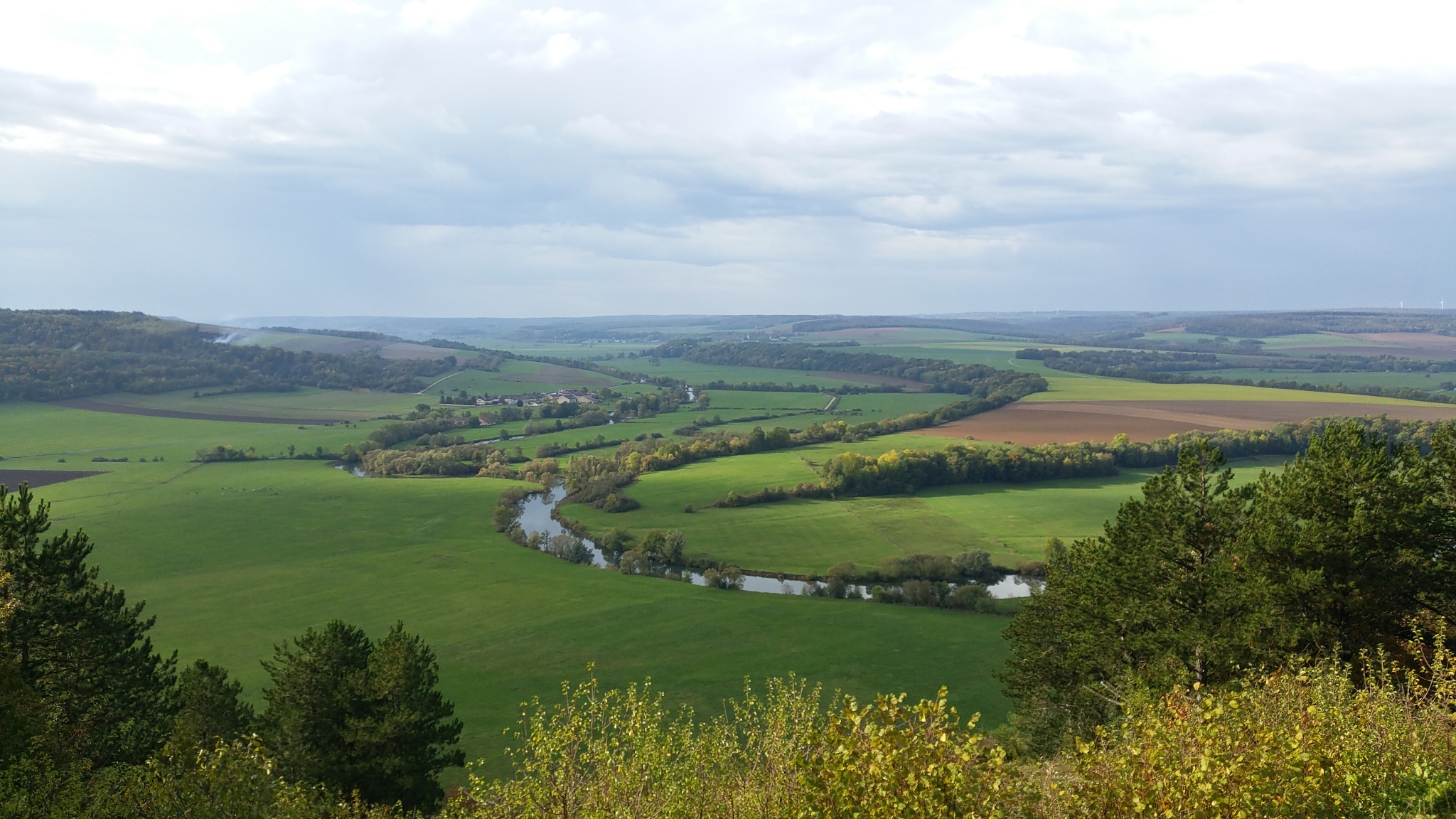
Au point déclaré se trouve un panneau explicatif du phénomène géologique qui se trouve à vos pieds, mais comme précisément vous êtes immergé dans ce mouvement de terrain, vous n'en percevez pas tous les éléments. retournez-vous et regardez au loin vers le Nord ouest. Je vous présente les éboulis de la Blanche côte. C'est en observant ces éboulis jumeaux de "la tête des Rousseaux" que vous allez décrypter votre environnement géologique.
Le but de vos observations du jour est de déterminer le type d'érosion subie par la tête des Rousseaux.
Pour cela le texte explicatif ci dessous sera d'une aide précieuse il est issu des séances de géologie de l'académie de Nancy Metz
1.Erosion mécanique. Pente d’équilibre par éboulisation
Lorsque des morceaux de roches se détachent d’une paroi par un processus mécanique, ils tombent, rebondissent, se fractionnent souvent, puis se stabilisent au pied de la paroi. Les éboulis sont alors granoclassés : si les débris de petite taille s’arrêtent rapidement quand la pente diminue, et les blocs plus importants ont tendance à aller plus loin puisque leur énergie cinétique est plus élevée. Quand seule la gravité intervient, l’éboulis présente en général un profil concave avec une pente longitudinale de 32 à 37° en limite d’équilibre (moyenne de 35°).

2. Erosion mécanique en fin de période glaciaire. Pente raide et rectiligne
En période glaciaire, les glaciers présents dans les régions montagneuses (Vosges) stockent l’eau sous forme solide. Lors du passage à l’interglaciaire qui suit (période cataglaciaire avec remontée des températures), les glaciers fondent et leur front recule ; l’eau s’écoule abondamment dans les bassins versants comme celle de la Meuse.
L’érosion mécanique de l’eau d’un fleuve tumultueux à la base d’une colline (calcaire par exemple) attaque cette dernière par la base obligeant la colline à conserver une pente raide (supérieure à 38°). De plus les alternances gel-dégel y sont encore nombreuses et fractionnent les calcaires en petites plaquettes de taille semblable ). Ces dernières s’éboulent vers le bas de pente où elles sont emportées par les flots de la Meuse. Ainsi la roche calcaire de la colline est progressivement attaquée par le gel, et la pente rectiligne toujours raide remonte vers le haut, jusqu’à ce que l’éventuelle corniche verticale qui surmontait la colline ait disparu. On a alors un versant réglé avec érosion complète de sa paroi sommitale.

Objectif : déterminer si la Tête des Rousseaux correspond à un modelé d’érosion classique lié à la gravité ou à un modelé post-glaciaire.
Pour cela, il faudra déterminer sa pente :
Rendez-vous en N48° 31.968 E5°44.481 relevez votre altitude et dimensionnez les plaquettes.
Allez ensuite en N48° 31.911 E5°44.414 faites de même je vous laisse débattre avec monsieur Pythagore
Question 1 :
Ces deux collines appelées aussi cuestas appartiennent à quel mouvement de terrain?
Question 2 :
Quel type d'érosion à donné naissance à ces éboulis?
Question 3 :
Quelle est la couleur de ces éboulis?
Question 4 :
Quelle roche compose majoritairement cette cuesta?
Petit bonus une photo de vos découvertes (fossiles) au sein de ces roche sera appréciée et complètera utilementvotre prospection.
"Loguez cette cache "Found it" et envoyez-moi vos propositions de réponses soit via mon profil, soit via la messagerie geocaching.com (Message Center), et je vous contacterai en cas de problème."

(excuse me for the rough translation, google is my best friend)
I propose here a strange concept of earth cache.
At the declared point is a panel explaining the geological phenomenon at your feet, but as you are immersed in this movement of terrain, you do not perceive all the elements. turn around and look away to the northwest. I present you the scree of the White Coast. It is by observing these twin screes of "the head of the Rousseaux" that you will decrypt your geological environment.
The purpose of your observations of the day is to determine the type of erosion suffered by the Rousseaux's head.
For that the explanatory text below will be of a precious help it comes from the sessions of geology of the academy of Nancy Metz
1. Mechanical erosion. Slope of balance by scree
When pieces of rock come loose from a wall by a mechanical process, they fall, bounce, split often, and then stabilize at the foot of the wall. The scree is then graded: if the small debris stop quickly when the slope decreases, and the larger blocks tend to go further since their kinetic energy is higher. When only gravity is involved, the scree generally has a concave profile with a longitudinal slope of 32 to 37 ° at the equilibrium limit (average of 35 °).
2. Mechanical erosion at the end of the ice age. Steep and straight slope
In the ice age, glaciers in mountainous regions (Vosges) store water in solid form. During the transition to the interglacial that follows (cataglacial period with rising temperatures), the glaciers melt and their forehead back; the water flows abundantly in the watersheds like that of the Meuse.
The mechanical erosion of the water of a tumultuous river at the base of a hill (limestone for example) attacks the latter by the base forcing the hill to maintain a steep slope (greater than 38 °). Moreover, the freeze-thaw alternations are still numerous and divide the limestones into small platelets of similar size). The latter are sinking downhill where they are washed away by the waves of the Meuse. Thus the limestone rock of the hill is gradually attacked by frost, and the steep straight slope climbs upwards, until the possible vertical cornice which surmounted the hill has disappeared. We then have a regulated slope with complete erosion of its summit wall.
Objective: to determine if La tête des Rousseaux corresponds to a classical erosion model linked to gravity or post-glacial modeling.
For this, it will be necessary to determine its slope:
Rendez-vous in N48 ° 31.968 E5 ° 44.481 note your altitude and size the pads.
Then go N48 ° 31.911 E5 ° 44.414 do the same I let you debate with Mr. Pythagoras
Question 1:
These two hills also called cuestas belong to which movement of ground?
Question 2:
What kind of erosion gave birth to these scree?
Question 3:
What is the color of these scree?
Question 4:
What rock mainly composed this cuesta?
"Log this cache" Found it "and send me your suggested answers either through my profile or via the messenger geocaching.com
(Message Center), and i will contact you in case of problems."