For the purposes of logging this cache you will be asked to answer the following questions. These are listed at the beginning and end of the cache description for your convenience. Please bear these in mind when reading the listing below and while visiting the posted coordinates.
Logging Requirements
- Using what you’ve learned in this cache listing is the rock layer at the bottom of the basin Limestone or Shale? What characteristic(s) identify it as such?
- What is the rate of water flow in gallons per minute? (Read the plaque.)
- Include a picture of yourself or a personal item that identifies you (i.e. your name clearly legible written on a piece of paper) at the site in your log or when submitting your answers to me.
Please Note: When submitting answers for a group please mention the names of each account.
This listing has 5 sections:
- What is an EarthCache?
- History
- Geology
- Water Flow
- Claiming this EarthCache

What is an EarthCache?
An EarthCache is the magical combination of geocaching and geological discovery. They vary greatly from traditional geocaches in that there is NO PHYSICAL CONTAINER! Once at the EarthCache site, take in the scenery, the geological marvels or oddities, and read the cache description. You will likely be asked to answer some questions about the site and take a picture. You can email the cache owner or use the Message Center to send answers to the required questions. Please don’t be intimidated or anxious about answering the questions. They are not graded and were meant to enrich your visit, open your eyes and provide you with new knowledge and insights about the location. Most importantly have fun!
History
Like most US towns Kansas City’s skyline has evolved immensely over the years. The posted coordinates for this cache was once just a rocky outcropping where the Kansa Indians hunted. As the city expanded Union Station opened in 1914 just Northwest of here. As a result, this adjacent land with its elevation and sturdy rock foundation became an ideal spot to display advertising billboards to the more than 600,000 commuters arriving and departing the train station each year. Consequently, it became known as Signboard Hill.

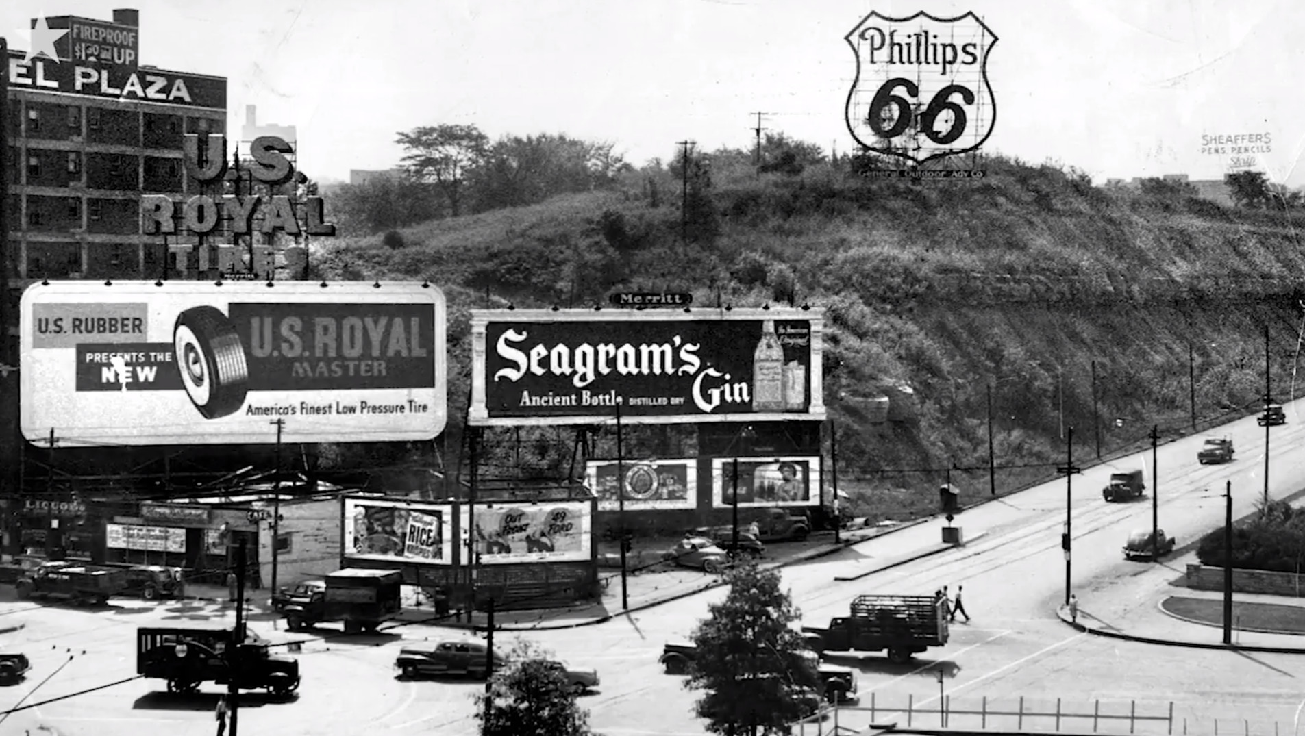
Before there was a Country Club Plaza, Kansas City had a Hotel Plaza of no relation. Rather, it took its name from its proximity to a stretch of pavement known as the Union Station Plaza (actually 24th street, and later Pershing Road), fronting the train station. Opened in the summer of 1922, the Plaza was a slender, nine-story building just east of Main street at the base of the eyesore that was Signboard Hill. The top floor of the Plaza in those early years provided excellent views of construction work on the new Liberty Memorial, across Main.


By 1969 it had become cheap housing, down on its luck. That year it was dynamited into rubble for the construction of another hotel, today called the Westin Crown Center. While removing rubble and preparing the landscape architect Harry Weese discovered a newly exposed bluff of Limestone and Shale rising 70 feet above the street. He decided to incorporate this into the design of the building and this beautiful landscape piece made from the existing rock is the result.

Geology
The rocks of this location are sedimentary. Sedimentary rocks form when weathered and eroded rocks or organic material break into smaller pieces and settle in place. This sediment may be transported to a new site (often a lake, river or sea) and deposited in layers that become buried and compacted. Cemented together, the particles form new sedimentary rocks. Two of the most common types of sedimentary rocks in Missouri are Limestone and Shale. In 1974 a geological study was completed here that identified 5 types of shale and 4 types of limestone.

Limestone is a relatively soft, light-colored sedimentary rock (rated 3-4 on Moh’s scale of hardness). It is believed that, millions of years ago, the area where you now stand was at the bottom of an ocean. Many marine organisms have a skeleton that is primarily made of calcium, and when they die, only the calcium skeletons remain on the bottom of the ocean floor. Over several million years, these skeletons landing on top of each other build up a layer of calcium compounds on the ocean floor, and the weight of the layers on top press together the lower layers. Eventually these layers become a rock called limestone.

Shale is a clastic rock (composed of fragments of pre-existing minerals and rock) that forms from the compaction of silt and clay-size mineral particles that we commonly call "mud." This composition places shale in a category of sedimentary rocks known as "mudstones." Shale is distinguished from other mudstones because it is fissile and laminated. "Laminated" means that the rock is made up of many thin layers. "Fissile" means that the rock readily splits into thin pieces along the laminations. The shale-forming process is not confined to Earth. The Mars rovers has found lots of outcrops on Mars with sedimentary rock units that look just like the shales found on Earth. The image below was shared by NASA and was transmited by the Mars Rover Curiosity in 2012.

Water Flow
Massive amounts of water can be discharged from rivers. The flow rate can vary immensely by season, weather and even time of day. During its peak season (June – August) the Niagra Falls has a flow rate as high as 600,000 gallons (2,271,247 liters) per second! This is obviously much smaller and is an engineered landscape piece powered by a recirculation system but the method to calculate for each is the same.
Volumetric flow rate is defined to be the volume of fluid passing by some location through an area during a period of time, this can be written as:
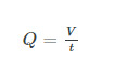
In this equation, "Q" is the Volumetric flow rate whereas "V" is the volume and "t" is the elapsed time. Consult the nearby plaque for more information on flow rate.
Claiming this EarthCache
In order to substantiate your visit and comply with the educational requirement for EarthCaches you have to submit your answers to the following questions to me via one of the in game communication options. Remember, just do your best there is no pass or fail mark, I am just looking for evidence that you have tried to learn something.
Logging Requirements
- Using what you’ve learned in this cache listing is the rock layer at the bottom of the basin Limestone or Shale? What characteristic(s) identify it as such?
- What is the rate of water flow in gallons per minute? (Read the plaque.)
- Include a picture of yourself or a personal item that identifies you (i.e. your name clearly legible written on a piece of paper) at the site in your log or when submitting your answers to me.
Please Note: When submitting answers for a group please mention the names of each account.
Do not wait on a reply from me before logging. FINDS which do not meet logging requirements however will be quietly removed!
Resources:
Tom's Town: Kansas City and the Pendergast Legend by William M. Reddig
Missouri Department of Natural Resources
MISSOURI MINERAL NEWS, v. 14, n. 4 (April 1974), p. 57-58
The Mars photograph was taken by NASA's Mars Rover Curiosity in 2012 Credit: NASA/JPL-Caltech/MSSS

2012 Kansas City Area Flash Mob
