
La Earthcache / The Earthcache
► La série géologique du plateau de Perrier
Au Sud de la Grande Limagne, le plateau de Perrier est à la confluence de nombreuses influences géologiques : phase sédimentaire de l'Oligocène, strato-volcanisme des Monts Dore, cours vagabond du paléo-Allier, coulées de boues dévastatrices, volcanisme strombolien, paléosol du Pliocène...
Ces traces d'une riche histoire géologique ont été mises à jour par la Couze Pavin en entaillant dans les terrains sur la rive gauche de la rivière.
Sur une dénivellation de plus de 150 mètres, le versant Sud de ce plateau offre ainsi une magnifique coupe géologique qui va nous permettre de reconstituer l’histoire de la région depuis sa limite Oligocène-Miocène jusqu'à aujourd'hui.
Cette série géologique [PERR] donne l'occasion de découvrir cette histoire au cours d'une petite randonnée entre le village de Perrier et le sommet du plateau.
Elles sera l'occasion d'étudier ses principales étapes de formation, mais également les influences géologiques qu'elles peuvent avoir dans la mise en place du paysage actuel et de ses sols.
Ce neuvième et dernier épisode va nous emmener à la découverte d'une formation sédimentaire assez particulière, les alluvions varvés.
► Les Alluvions varvés du Perrier
L'étude de la carte géologique de la zone ouest de la falaise de Perrier, entre les altitudes de 485 et 510-520 m, met en évidence des alluvions fluvio-lacustres.
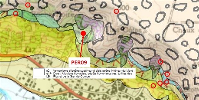
Bien que contemporain des alluvions fluviaux du paléo-Allier antérieur aux éruptions pliniennes, les formations sont, par leur structure et leur origine, très différentes.
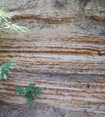
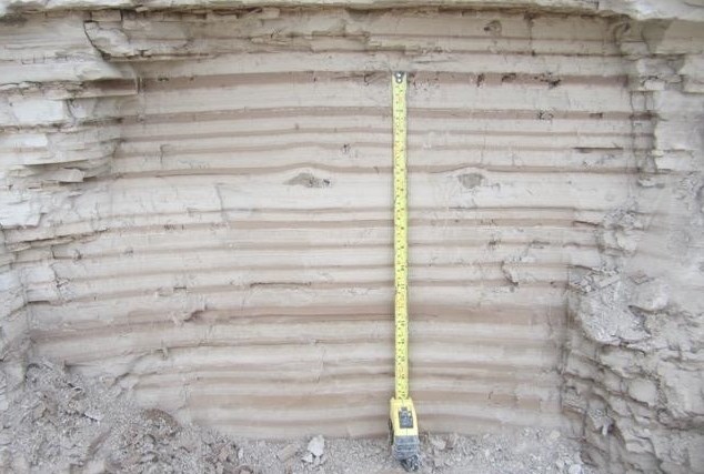
Elles se matérialisent par une petite falaise présentant une alternance serrée, d’allure varvée, de lits orangés, ferrugineux (colorés par de l’oxyde ferrique) et blancs constitués de sables fins et de limons légèrement indurés.
Cette sédimentation d’éléments aussi fins et bien stratifiée horizontalement n’a pu se faire que dans un milieu aquatique très calme, par exemple en bordure d’un système fluviatile, dans la plaine d’inondation ou dans une formation lacustre bordant le paléo-Allier, qui avait son cours plus à l'est.
► Caractéristiques et formation des varves
Une varve est une couche ou strate sédimentaire qui s'est déposée en une année, au fond d'un lac. Cette stratification est due à des variations annuelles du climat (saisons).
Les différences de coloration entre les strates sont dues à une alternance des varves d'hiver et des varves d'été, au rythme des saisons hydrologiques.
Les feuillets claires sont généralement plus épais et sont faits d'éléments plus grossiers, charriés par les abondantes eaux de fonte estivales.
Les feuilles plus sombres sont plus minces et correspondent à un matériel fin déposé l'hiver.
L'étude des varves est utile pour dater des événements climatiques et géologiques récents.
► Classification des sédiments alluviaux
Les sédiments des varves peuvent être classer selon leur taille, on appelle cela la classification granulométrique.
Comme pour un sol, cela permettra de caractériser la texture du feuillet de varve, et donc de déterminer ses conditions de dépôts (eaux plutôt calmes ou agitées).

► Induration ferrique et érosion différentielle
Certaines varves du Perrier présentent des caractéristiques particulières, dues à leur concentration en hydroxydes de fer ou en hydroxyde d'aluminium.
En terme d'horizons pédologiques, on parle alors d'horizons placiques Femp.
Ce sont des horizons d’accumulation de fer, apparaissant en bancs très durs (indurés), minces (1 à 10 mm) et souvent discontinus, de couleur rouille très prononcée.
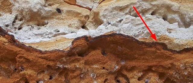
Leur formation peut provenir, soit de dépôt de sédiments naturellement riches en fer, soit de la migration du fer des horizons supérieurs qui s'accumulent pour former cette varves ferriques.
Cette forte concentration en hydroxydes de fer a pour conséquence de consolider l'ensemble de la couche, jusqu'à en faire une véritable carapace, qui va résister beaucoup mieux à l'érosion par l'eau météoritique que les varves voisines peu cimentées.
Au fil du temps, cela va créer un phénomène d'érosion différentielle verticale, mettant en relief ces couches d'horizons placiques au niveau de l'affleurement.
► The geological series of the Perrier plateau
South of Great Limagne, the Perrier plateau is at the confluence of many geological influences: sedimentary phase of the Oligocene, strato-volcanism of the Monts Dore, vagabond course of the Paleo-Allier, devastating mudslides, Strombolian volcanism, paleosol Pliocene ...
These traces of a rich geological history have been updated by the Couze Pavin by hacking into the land on the left bank of the river.
On a slope of more than 150 meters, the southern slope of this plateau offers a beautiful geological section that will allow us to reconstruct the history of the region from its Oligocene-Miocene limit until today.
This geological series [PERR] gives the opportunity to discover this story during a short hike between the village of Perrier and the top of the plateau.
It will be an opportunity to study its main stages of formation, but also the geological influences they may have in the setting up of the current landscape and its soils.
This seventh episode will take us to the discovery of a stratigraphic layer visible on almost the entire section of the Perrier Plateau, an alluvial stratum characterized by its altitude.
What are the origins and characteristics of this particular geological layer?
► Characteristics
This layer is visible all along the cliffs bordering the plateau, from the trail that climbs from troglodyte habitats to the trail that goes down to the Perrier before Pardines.
It is thus visible:
- At the level of the Maurifolet Tower.
- Along the slopes, at the level of "factories with fairy chimneys".
- In section along the trails that descend from the top of the plateau to the plain above Rocas Neyras.
A number of elements make it possible to determine that it is a single formation covering a very large area but a small thickness:
- A characteristic altitude, 550 meters.
- A fine geological stratum, without any comparison with the formations of fluvial conglomerates antépliniens (from 30 to 40 meters) being under the Lahar to 480 meters of altitude.
- A fairly homogeneous thickness, with a layer of thicker blocks of about 20 cm rounded clasts, sometimes of color drawing on dark blue / black very hard (basalt pebbles?), Sometimes brown.
- A finer granulometric environment layer than the blocks (which form the backbone), having a metric power.
- A stratigraphic separator systematically present between the two Lahars (small blocks and large blocks).
► Formation
Driven by the establishment of Lahar small blocks following the volcanic episodes of the Strato-volcano Mount Dore, the Allier is "returned" to the Perrier, but in a different form of ante-Plinian formations, explaining the delicacy of the layer geological.
The river thus returned to the Perrier in a much wider valley, very spread out, with flood plains very extensive since its former valley was filled by the lahar and that the Allier could not yet overcrow it.
What the valley has lost in depth, it has gained in width for the same flow.
The variety of different points of view where this layer is visible (generally in height except when it is crossed at its altimetric level) gives an idea of the extent of the river bed, which should have been several kilometers wide, forming a wide meandering streams.
However, the course and flow of this meandering river has varied over time, resulting in a change in the size of the sediments that make up the layers of this river stratum.
Thus, could have succeeded in the same place different areas of the river:
- Areas of high energy (main course and secondary arms), or have deposited pebbles.
- Quiet areas on the convex edge of the meanders, where sand has settled.
- Quasi-stagnant areas such as wet meadows (major river bed), where silty sediments have been deposited.
The Allier will be definitively chased from the Perrier plateau by setting up Lahar at Gros Blocs.
He will then drive his new valley in contact between the front of the Lahar flow and the Oligocene Limagne, east of Issoire.
► Nature and classification of river sediments
Fluvial alluvial deposits are of very diverse natures: silt, clay, peat, sand, gravel.
It is possible to categorize these sediments of detrital origin according to their size, one speaks then of classification granulometric.
Moreover, since the sediments have been transported by Allier waters, it is possible to determine the mean and maximum flows of the river at a given moment by observing the size of these sediments, which have directly related deposit conditions. at the speed of the current, according to the Hjuström diagram.
► Sources bibliographiques / Bibliographical sources
Les Questions / The Questions
La lecture attentive du descriptif de la cache, ainsi qu'une observation des éléments de terrain et un peu de déduction sont normalement suffisants pour répondre aux questions de cette EarthCache.
A careful reading of the description of the cache, as well as observation of terrain features and some deduction is usually sufficient to answer questions of this EarthCache.
Questions pour valider : "Alluvions Varvés pour terminer"
Questions to validate: "The river stratum '550 meters'"
Vous voici devant une falaise faite d'alluvions varvés, sur la gauche du chemin (photo WP1).
Here you are in front of a digging of the cliff, strewn with numerous holes of burrowing insects, from where its name of grotto of the fourmillions (photo WP1).
Rest assured, we are not here to observe these charming insects, but the stratum where these colonies have developed!
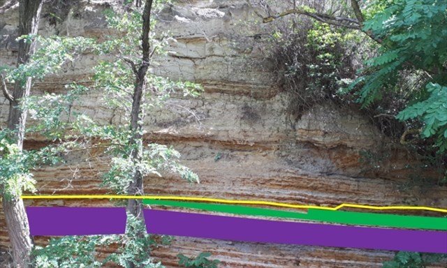
- Question 1 : Quelle couleur à cette couche sous la zone verte ? Quelle épaisseur par rapport aux couches voisines ? Déduisez-en la saison de dépôt des sédiments de cette couche.
- Question 1 : Using your GPS, take your altitude. Is this altitude consistent with your stratigraphic position on the Perrier plateau?
- Question 2 : Prenez un peu de sédiments de cette couche verte, et rouler la entre vos doigts. En observant les grains de cette couche, déduisez-en les conditions de dépôts des sédiments. Cela confirme t-il les éléments de la question 1 ?
- Question 2 : Take some sediment from the blue top layer A ("roof" of the cave) between your fingers and give the average grain size. Classify them according to the particle size classification. In your opinion, what were the depositional conditions of this upper part of the stratum?
- Question 3 : Observez la couche de varves sous la zone jaune. Evaluez sa couleur et sa dureté. A quel élément cela est-il dû ? Quel est le nom de ce type de couche ?
- Question 3 : Take some sediment from the yellow intermediate B area (bottom of the cave) between your fingers and give the average grain size. Classify this stratum according to the particle size classification. What do you think were the deposit conditions of this lower part?
- Question 4 : Observez les différentes couches varvées sous la zone violette, et comparez leur degré d'érosion les unes par rapport aux autres. Quel effet cela donne-t-il à la falaise ? Expliquer ces variations.
- Question 4 : At ground level of the cave (red area C), you can see larger blocks. What form are they? Does this seem consistent to you? Determine the speed of the river at the time of formation of this stratum. In what part of the river we found ourselves?
- Question 5 : Prenez une photo en Noir et Blanc de vous ou d'un élément vous identifiant devant la falaise d'alluvions varvées (mais pas le WP1).
Cette photo devra au choix nous être transmise avec les réponses ou être ajoutée à votre log.
- Question 5 : Take a black and white photo of yourself or an item identifying you with the ant grotto in the background.
This photo will have to be sent to us with the answers or to be added to your log.
Vous pouvez vous loguer sans attendre notre confirmation,
mais vous devez nous envoyer les réponses en même temps soit par mail via notre profil (
fafahakkai), soit via la messagerie geocaching.com (Message Center).
S'il y a des problèmes avec vos réponses nous vous en ferons part.
Les logs enregistrés sans réponses et sans photo seront supprimés.
You can log this cache without waiting for our confirmation, but you must send us the answers at the same time, by e-mail via our profile (fafahakkai) or by the system of Message Center of geocaching.com.
If there is a problem with your answers we will notify you. The logs recorded without answers and photo will be deleted.
Rappel concernant les « Earthcaches »: Il n'y a pas de conteneur à rechercher ni de logbook à renseigner. Il suffit de se rendre sur les lieux, de répondre aux questions ci-dessus et de nous renvoyer les réponses.
Reminder concerning "Earthcaches": there is neither a container to look for nor a logbook to sign. One need only go to the location, answer to the differents questions and send us the answers.