
La Earthcache / The Earthcache
► La série géologique du plateau de Perrier
Au Sud de la Grande Limagne, le plateau de Perrier est à la confluence de nombreuses influences géologiques : phase sédimentaire de l'Oligocène, strato-volcanisme des Monts Dore, cours vagabond du paléo-Allier, coulées de boues dévastatrices, volcanisme strombolien, paléosol du Pliocène...
Ces traces d'une riche histoire géologique ont été mises à jour par la Couze Pavin en entaillant dans les terrains sur la rive gauche de la rivière.
Sur une dénivellation de plus de 150 mètres, le versant Sud de ce plateau offre ainsi une magnifique coupe géologique qui va nous permettre de reconstituer l’histoire de la région depuis sa limite Oligocène-Miocène jusqu'à aujourd'hui.
Cette série géologique [PERR] donne l'occasion de découvrir cette histoire au cours d'une petite randonnée entre le village de Perrier et le sommet du plateau.
Elles sera l'occasion d'étudier ses principales étapes de formation, mais également les influences géologiques qu'elles peuvent avoir dans la mise en place du paysage actuel et de ses sols.
Ce huitième épisode va nous plonger dans une des parties les plus anciennes de l'histoire géologique du plateau de Perrier-Pardines, les premières traces d'une histoire volcanique qui connaîtra de nombreux épisodes dans cette partie est de l'Auvergne.
► Perrier-Pardines, une chaîne des Puys avant l'heure
Sur la carte géologique, une formation rocheuse est apparente dans la partie ouest de la falaise du plateau, produit du volcanisme Pliocène du Cézallier.

Le stratovolcan à l'origine du massif du Cézallier est apparu il y a 8 millions d’années et s’est éteint il y a 3 millions d’années.
A la différence de celui du Mont Dore, il s'agit d'un ensemble volcanique de type effusif (volcanisme strombolien).
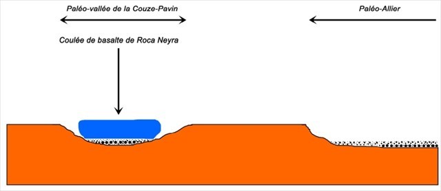
Il y a 3,7 Ma (Pliocène terminal), une éruption d'un volcan de la bordure Nord-Est du Cézallier, le volcan des Ranoux, a provoqué un épanchement de lave qui a suivi le cours de la paléo-Couze du Pavin jusqu'à la zone qui deviendra le plateau du Perrier.
Cette coulée de lave, appelée formation de la Roca Neyra, présente une épaisseur peu puissante (environ 20 mètres) mais a entamé la confluence de la Couze avec le Paléo-Allier.
Cette formation volcanique strombolienne ne doit pas être confondue avec celles de la Chaîne des Puys voisines, beaucoup plus jeunes (il y a moins de 100000 ans), ni avec la mise en place des Nuées Ardentes et les Lahars du « Complexe de Perrier » (2.4 millions d'années).
► Le basalte de la Roca Neyra
Cet épisode volcanique pliocène est de type strombolien. Dans le cas de ce volcanisme, le magma provient d'une chambre magmatique à grande profondeur (jusqu'à 10 km).
Il est très chaud (laves ayant une température de 1000 à 1150°C) et d’une composition plutôt fluide. Lors de l’éruption, les gaz qu’il contient le poussent vers l’extérieur. Il en résulte une sortie de lave fluide, qui s’écoule facilement le long du volcan, sans explosion.
La cristallisation suite au refroidissement de ce magma donne principalement des basaltes, une roche sombre dont la couleur s'explique par une grande richesse en minéraux ferromagnésiens comme le pyroxène (25 à 40 %) et l'olivine (10 à 25 %).
Selon le Diagramme de Streckeisen, on parle alors de roche mélanocrate à holomélanocrate (sombre à très sombre).

Cette roche présente une structure microlithique, c'est à dire des tout petits cristaux, à la différence de roche magmatique plutonique (comme le granite) présentant une structure grenue (cristaux millimétriques à centimétriques).

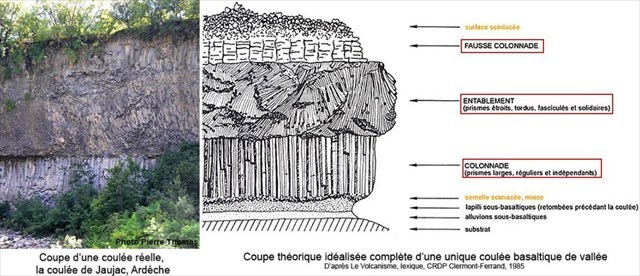
La cristallisation du magma basaltique peut également entraîner un phénomène de prismation.
Lors du refroidissement, la lave présente une contraction thermique par refroidissement. La partie inférieure, qui se refroidit ou s'assèche plus lentement, se fracture de la surface vers la profondeur sous forme de prismes sub-verticaux.

Plus le refroidissement est lent et plus les prismes seront réguliers ; le gradiant de température variant avec la position dans la couche de lave en cours de refroidissement, les primes de basalte n'auront pas la même forme selon le niveau de profondeur dans cette couche.
Vu de profil, une coulée volcanique prismée se caractérise par trois systèmes de prismation superposés :
- au sommet de la coulée, la fausse colonnade : prismes de dimensions verticales variables correspondant à des cellules de convection lorsque la lave est encore fluide.
- au cœur de la coulée, l'entablement : le basalte est débité en prismes disposés très irrégulièrement : verticaux, obliques, avec des formes souvent tordues.
- à la base de la coulée, la vraie colonnade : les prismes sont réguliers, nommés orgues basaltiques pour leur forme hexagonale à section décimétrique et parfaitement verticaux.
► Altération du basalte de la Roca Neyra
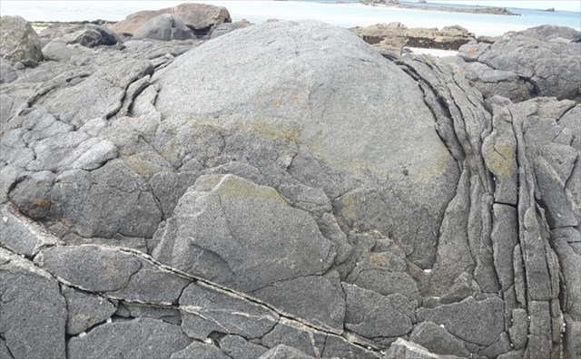
Plusieurs facteurs donnent des caractéristiques d'altération particulières au basalte de la Roca Neyra.
~ Les pelures d'oignons
Le basalte, comme la plupart des roches magmatiques (ex : granites, dolérite,...) sont des roches dures et cohérentes.
L'altération se fait au travers de fractures (ou diaclases) dans lesquels l'eau va s'infiltrer.
Cette eau pénètre dans des diaclases et altère les minéraux constituant le basalte (feldspaths et pyroxène).
Progressivement, les diaclases s’élargissent et les blocs de basalte prennent des formes arrondies caractéristiques.
Ces blocs s’altèrent en se désagrégeant par couches successives qui desquament les unes après les autres, donnant un débit en pelures d’oignons.
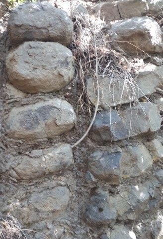
~ La pile d'assiettes
Le basalte se présente généralement sous une forme prismée. A Roca Neyra, des zones se présentent sous la forme d'orgues débités transversalement en assiettes.
Les bords de primation étant des zone privilégiées d'attaque par l'eau, cela donne des débits d’altération bien alignés verticalement « en pile d’assiettes ».
~ Les compayrés
Dégagés et mis en relief pour la plupart depuis le Pliocène, ces basaltes anciens sont soumis à un mode d'érosion présentant quelques particularités du fait de sa position sur le socle sédimentaire de Limagne, les calcaires oligocènes.
La pression exercée par le poids de la lave, s'ajoutant à l'action dissolvante et émolliente des eaux d'infiltration sur les marno-calcaires, contraint ceux-ci à jouer sur les bords.
La coulée portant à faux sur son support se fend longitudinalement en lisière. Un pan de basalte s'isole, bascule plus ou moins lentement et finit par s'abattre, donnant des amas de blocs basaltiques croulants que les vignerons appellent des compayrés.
► The geological series of the Perrier plateau
South of Great Limagne, the Perrier plateau is at the confluence of many geological influences: sedimentary phase of the Oligocene, strato-volcanism of the Monts Dore, vagabond course of the Paleo-Allier, devastating mudslides, Strombolian volcanism, paleosol Pliocene ...
These traces of a rich geological history have been updated by the Couze Pavin by hacking into the land on the left bank of the river.
On a slope of more than 150 meters, the southern slope of this plateau offers a beautiful geological section that will allow us to reconstruct the history of the region from its Oligocene-Miocene limit until today.
This geological series [PERR] gives the opportunity to discover this story during a short hike between the village of Perrier and the top of the plateau.
It will be an opportunity to study its main stages of formation, but also the geological influences they may have in the setting up of the current landscape and its soils.
This eighth episode will plunge us into one of the oldest parts of the geological history of the plateau Perrier-Pardines, the first traces of a volcanic history that will experience many episodes in this eastern part of the Auvergne.
► Perrier-Pardines, a chain of Puys before the hour
On the geological map, a rock formation is apparent in the western part of the plateau cliff, produced by Pliocene volcanism from Cézallier.
The stratovolcano at the origin of the Cézallier massif appeared 8 million years ago and died 3 million years ago.
Unlike Mount Dore, it is a volcanic ensemble of effusive type (Strombolian volcanism).
There is 3.7 Ma (Late Pliocene), an eruption of a volcano on the northeastern edge of the Cézallier, the Ranoux volcano, caused an effusion of lava that followed the course of the Paleo-Couze Pavin to the area that will become the Perrier plateau.
This lava flow, called formation of the Roca Neyra, has a weak thickness (about 20 meters) but has begun the confluence of the Couze with the Paleo-Allier.
This Strombolian volcanic formation should not be confused with those of the neighboring Chaîne des Puys, much younger (less than 100 000 years ago), nor with the setting up of the Ardentes and Lahars Clouds of the "Perrier Complex" (2.4). million years).
► The basalt of Roca Neyra
This Pliocene volcanic episode is of Strombolian type. In the case of this volcanism, the magma comes from a magma chamber at great depth (up to 10 km).
It is very hot (lava having a temperature of 1000 to 1150 ° C) and a rather fluid composition. During the eruption, the gases it contains pushes it outwards. This results in a fluid lava outlet, which flows easily along the volcano, without explosion.
The crystallization following the cooling of this magma gives mainly basalts, a dark rock whose color is explained by a great wealth of ferromagnesian minerals such as pyroxene (25 to 40%) and olivine (10 to 25%).
According to the diagram of Streckeisen, one speaks then of melanocratic rock with holomelanocrate (dark to very dark).
This rock has a microlitic structure, ie very small crystals, unlike plutonic magmatic rock (like granite) with a granular structure (millimetric to centimetric crystals).
The crystallization of the basaltic magma can also lead to a phenomenon of prismation.
During cooling, the lava has a thermal contraction by cooling. The lower part, which cools or dries more slowly, fractures from the surface to the depth in the form of sub-vertical prisms.
The slower the cooling, the more regular the prisms; the temperature gradient varying with the position in the lava layer being cooled, the basalt premiums will not have the same shape depending on the level of depth in this layer.
Viewed in profile, a prismatic volcanic flow is characterized by three superimposed prismatic systems:
at the top of the casting, the false colonnade: prisms of variable vertical dimensions corresponding to convection cells when the lava is still fluid.
- in the heart of the cast, the entablature: the basalt is cut into prisms arranged very irregularly: vertical, oblique, with shapes often twisted.
- at the base of the casting, the true colonnade: the prisms are regular, named basaltic organs for their hexagonal shape with decimetric section and perfectly vertical.
► Alteration of the basalt of Roca Neyra
Several factors give particular alteration characteristics to the basalt of Roca Neyra.
~ Onion peels
Basalt, like most magmatic rocks (eg granite, dolerite, ...) are hard and consistent rocks.
The alteration is done through fractures (or diaclases) in which the water will infiltrate.
This water penetrates diaclases and alters the minerals constituting the basalt (feldspars and pyroxene).
Gradually, the joints widen and the basalt blocks take on characteristic rounded shapes.
These blocks are altered by disintegrating in successive layers which peel one after the other, giving a flow of peel onions.
~ The stack of plates
Basalt is usually in a prism form. In Roca Neyra, areas are in the form of organs cut transversely into plates.
The primation edges being privileged zones of attack by the water, this gives flow of alteration well aligned vertically "in pile of plates".
~ Companions
These ancient basalts, mostly cleared and highlighted since the Pliocene, are subject to an erosion mode with some peculiarities because of their position on the sedimentary bedrock of Limagne, the Oligocene limestones.
The pressure exerted by the weight of lava, added to the dissolving and emollient action of seepage water on marl-limestone, forces them to play on the edges.
The casting overhanging its support splits longitudinally on the edge. A section of basalt isolates itself, rocks more or less slowly and ends up falling, giving clumps of crumbling basaltic blocks that the vine growers call compayrés.
► Sources bibliographiques / Bibliographical sources
Les Questions / The Questions
La lecture attentive du descriptif de la cache, ainsi qu'une observation des éléments de terrain et un peu de déduction sont normalement suffisants pour répondre aux questions de cette EarthCache.
A careful reading of the description of the cache, as well as observation of terrain features and some deduction is usually sufficient to answer questions of this EarthCache.
Questions pour valider :"Les Rocas Neyras"
Questions to validate: "The Rocas Neyras"
Point 1 : N 45° 33.206' E 003° 11.121'
Sur la gauche du chemin en descendant vers Perrier, vous pouvez voir un bel affleurement de la formation de la Roca Neyra.
Regarder à vos pieds des blocs de roches qui s'y sont détachés (questions 1 et 2), puis prenez un peu de recul pour voir la formation dans son ensemble (question 3).
On the left of the path going down to Perrier, you can see a beautiful outcrop of the formation of Roca Neyra.
Look at blocks of loose rocks at your feet (questions 1 and 2), then take a step back to see the formation as a whole (question 3).
- Question 1 : Quelle est la couleur de la formation ? Quelle est l'origine de cette couleur ? A votre avis, pensez que cette formation de la Roca Neyra ("Roche Noire" en patois) porte bien son nom ?
- Question 1 : What is the color of the training? What is the origin of this color? In your opinion, think that this formation of the Roca Neyra ("Black Rock" in patois) is aptly named?
- Question 2 : Observer la structure cristalline et la taille des cristaux de ces blocs. Peut-on parler de roche grenue ?
- Question 2 : Observe the crystal structure and crystal size of these blocks. Can we talk about granular rock?
- Question 3 : De vos réponses des questions 1 et 2, déduisez la nature de la roche magmatique en utilisant le Diagramme de Streckeisen (justifier votre réponse).
- Question 3 : From your answers to questions 1 and 2, deduce the nature of the magmatic rock using the Streckeisen Diagram (justify your answer).
- Question 4 : Décrivez l'ensemble de l'affleurement qui porte les stigmates de deux phénomènes d'altération. Quels sont-ils ? Justifiez votre réponse.
- Question 4 : Describe the entire outcrop bearing the stigmas of two weathering phenomena. What are they ? Justify your answer.
Point 2 : N 45° 33.207' E 003° 11.147'
Poursuivons le chemin jusqu'au WP2, jusqu'à un autre affleurement de formation de la Roca Neyra, cette fois non altéré.
Continue on to WP2 until another formation outcrop of Roca Neyra, this time unaltered.
- Question 5 : Décrivez les formes prises par la roche à cet endroit. Déduisez en à quelle niveau de la coulée basaltique prismée vous vous trouvez.
- Question 5 : Describe the shapes taken by the rock here. Decide at what level of prismatic basalt casting you are.
- Question 6 : Prenez une photo en Noir et Blanc de vous ou d'un élément vous identifiant sur le chemin, sans montrer les affleurements des WP1 et WP2.
Cette photo devra au choix nous être transmise avec les réponses ou être ajoutée à votre log.
- Question 6 : Take a black and white photo of yourself or an element identifying you on the way, without showing the outcrops of WP1 and WP2.
This photo will have to be sent to us with the answers or to be added to your log.
Vous pouvez vous loguer sans attendre notre confirmation,
mais vous devez nous envoyer les réponses en même temps soit par mail via notre profil (
fafahakkai), soit via la messagerie geocaching.com (Message Center).
S'il y a des problèmes avec vos réponses nous vous en ferons part.
Les logs enregistrés sans réponses et sans photo seront supprimés.
You can log this cache without waiting for our confirmation, but you must send us the answers at the same time, by e-mail via our profile (fafahakkai) or by the system of Message Center of geocaching.com.
If there is a problem with your answers we will notify you. The logs recorded without answers and photo will be deleted.
Rappel concernant les « Earthcaches »: Il n'y a pas de conteneur à rechercher ni de logbook à renseigner. Il suffit de se rendre sur les lieux, de répondre aux questions ci-dessus et de nous renvoyer les réponses.
Reminder concerning "Earthcaches": there is neither a container to look for nor a logbook to sign. One need only go to the location, answer to the differents questions and send us the answers.