Cascade de Brisecou : Le Monolithe à Réré
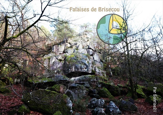
La Gorge dans laquelle nous nous trouvons entaille le versant sud granitique du bassin permien.
Voici un schéma reprenant sa mise en place :
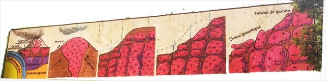
- Il y a 400 millions d’années, dans les profondeurs de la terre, se sont formées des chambres de magma de composition granitique. Cette matière a cristallisé en remontant à travers la lithosphère. En surface, une activité volcanique et sismique a secoué le Morvan.
- Il y a près de 300 millions d’années, le Morvan se soulève, créant un massif montagneux. Il est ensuite érodé, mettant à nu les granites.
- 4-5 Exposé aux intempéries et au gel, le granite se pulvérise. Des failles se forment, créant ainsi des zones de faiblesse dans le massif. Les phénomènes d’altération apparaissent progressivement le long des fissures. L’eau entraîne l’arène granitique sous la forme de sable, laissant apparaître la falaise et les boules de granite visibles au pied de la falaise. Le granite, présentant un faciès très orienté, a une texture grenue constituée de quartz, de micas et de feldspaths.
Zoom Sur
Si dans un laboratoire, il est placé un échantillon de roches sous contraintes orientées grâce à une presse, deux familles de failles apparaissent automatiquement : elles forment un angle de 30 à 45 degrés par rapport à la contrainte majeure.
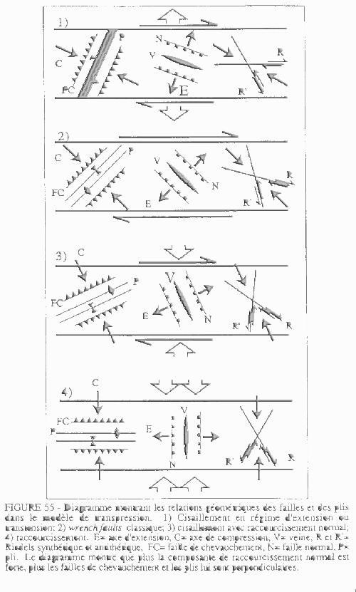
Grâce à cette modélisation, il est possible de replacer les contraintes dans l’observation sur le terrain.
Le monolithe présent devant vous a été soumis à une contrainte majeure verticale et une contrainte mineure horizontale.
Cette disposition est caractéristique de la dernière phase de l’orogenèse, lorsque la masse de la chaine de montagnes n’est plus compensée par la poussée tectonique : les reliefs s’écrasent sur eux même, et les bassins sédimentaires se forment.
Ceci correspond bien à l’environnement local : le bassin d’Autun et le granite sont datés de cette période de la fin de l’orogenèse.
Brisecou Waterfall: The Cliff
The Gorge in which we find ourselves cuts the southern granite slope of the Permian basin.
Here is a diagram showing its implementation:
1- 400 million years ago, in the depths of the earth, magma chambers of granitic composition are formed. This is a crystallized in montrance through the lithosphere. On the surface, volcanic and seismic activity rocked the Morvan.
2- Nearly 300 million years ago, the Morvan rises, the mountainous place. It is then eroded, exposing the granites.
3- 4-5 Exposed to bad weather and frost, granite sprays. Faults are formed, thus areas of weakness in the massif. The phenomena of alteration have gradually lengthened. The granite arena in the form of sand, the apparent cliff and the granite balls visible at the foot of the cliff. Granite, a highly oriented surface, a grainy texture made of quartz, micas and feldspars.
Zoom on
If, in a laboratory, a sample of press-stressed rocks is placed, two families of faults appear automatically: they form an angle of 30 to 45 degrees with respect to the major stress.
Thanks to this modeling, it is possible to place the constraints in the field observation.
The monolith present in front of you was subjected to a major vertical stress and a horizontal minor stress.
This arrangement is characteristic of the last phase of the orogenesis, when the mass of the mountain range is no longer compensated by the tectonic thrust: the reliefs collapse on themselves, and the sedimentary basins are formed.
This corresponds well to the local environment: the basin of Autun and the granite are dated from this period of the end of the orogenesis.
Rappel concernant les « Earthcaches »: Il n'y a pas de conteneur à rechercher ni de logbook à renseigner. Il suffit de se rendre sur les lieux et d'éxécuter les requêtes du géocacheur.
Loguez cette cache "Found it" et envoyez-moi vos propositions de réponses soit via mon profil, soit via la messagerie geocaching.com (Message Center), EN PRECISANT LE NOM ET CODE GC DE LA CACHE et je vous contacterai en cas de problème.
Il est aussi apprécié d'avoir des photos des géocacheurs sur les lieux de l''EarthCache. Sentez-vous inspiré de poster des photos de vous lors de cette visite (optionnelle mais sympathique)
---
Reminder concerning "Earthcaches": there is neither a container to look for nor a logbook to sign.
Log in this cache " Found it " and send me your answers proposals or via my profile or via geocaching.com messaging (Message Center ) , BY PROVIDING THE NAME AND GC CODE OF THE CACHE and I will contact you in case of problems .
We also enjoy seeing photographs of people visiting this EarthCache. Please feel free to log photos of your visit...(this is entirely optional but funny)
Grâce à la lecture du descriptif et votre observation, répondez aux questions suivantes :
Thanks to the reading of the description and your observation, answer the following questions:
Q1 Retrouvez les 4 fractures principales du monolithe dont vous ferez un croquis.
Q1 Find the 4 main fractures of the monolith that you will sketch.
JOYEUX & HAPPY EARTHCACHING !