LE DONJON DE MIRABEL
appelé aussi : Tour de Mirabel

Village de MIRABEL
Mirabel signifie « le lieu d'où la vue est belle ».
Depuis le village la vue embrasse le massif du Coiron, les Cévennes et la plaine jusqu'au rocher de Sampzon.
Le village de Mirabel s'est développé au pied du château du même nom qui apparait dans le courant du XIIème siècle. Du château, il ne reste que le donjon datant vraisemblablement du XIIe siècle. C'est l'un des rares encore aussi bien conservé en Ardèche puisqu'il est complet jusqu'à son sommet.
Les fortifications du village sont encore bien visibles avec ses 6 tours de la fin du Moyen-Âge.
En 1628, les protestants tenant la place forte de Mirabel en sont délogés par les armées de Richelieu qui mettent le siège devant le château tout en détruisant Privas.
Sur la commune de Mirabel s'étendent les terres du domaine du Pradel appartenant à Olivier de Serres, agronome précurseur du début du 17e siècle qui en a fait un terrain de cultures expérimentales.
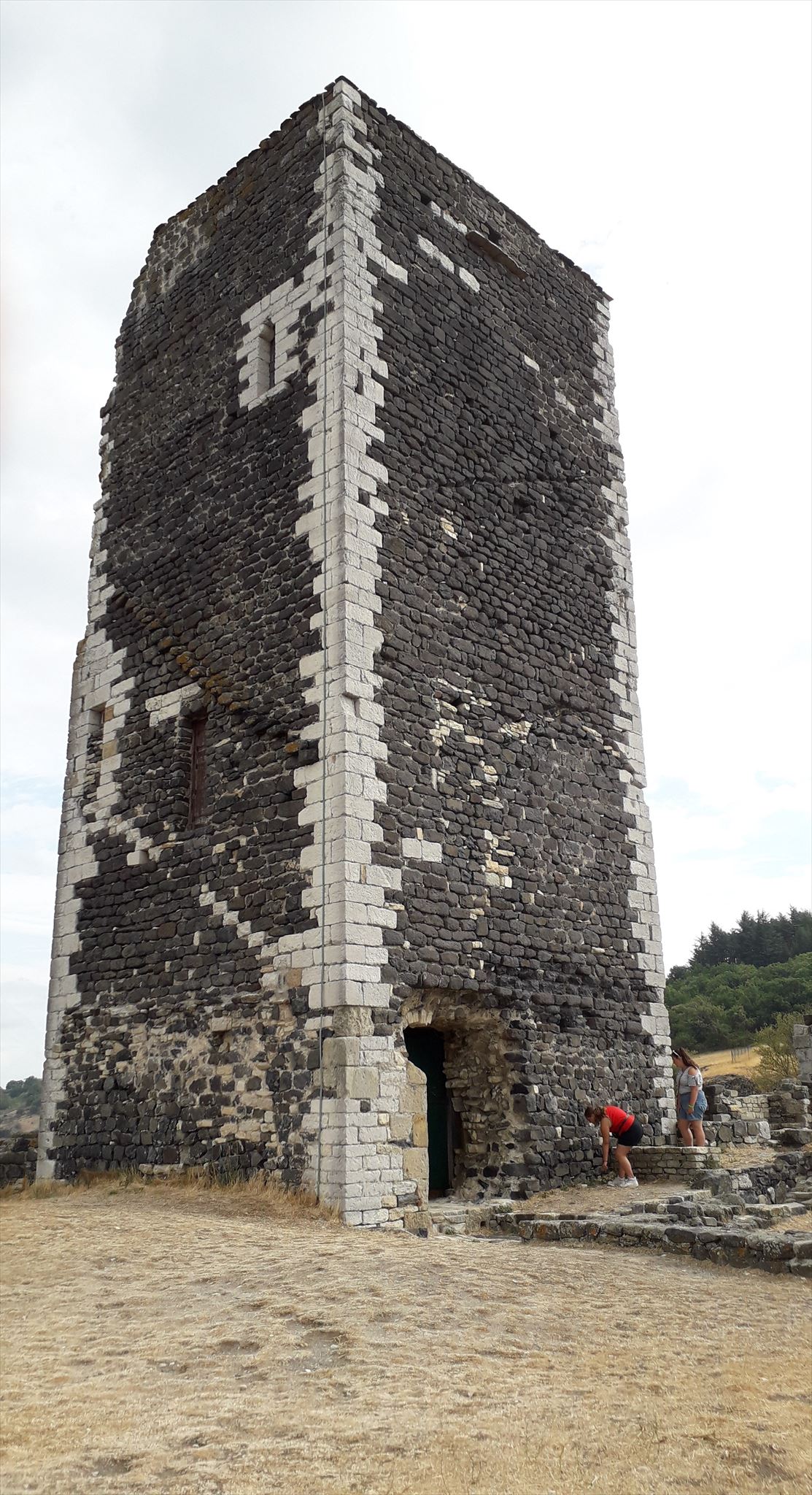
La Tour de Mirabel est le seul vestige de ces anciennes fortifications qui a réussi à passer au travers des guerres de religion. En effet, en juin 1628, les hommes de Montmorency détruisirent toutes les fortifications ne laissant que la tour.
L’ensemble fortifié était en fait constitué de deux châteaux : l’un catholique appartenant aux seigneurs de La Roche des Astars, l’autre aux seigneurs protestants d'Arlempdes. Le premier château, démantelé au XVIIe siècle ne conserve que quelques pans de murs à ras de terre trouvé (fouilles + reconstitution) par son nouveau propriétaire à partir de 1970. Le second château, lui aussi détruit, a pourtant gardé son donjon carré. Il est construit en moellons de basalte noir et possède ses chaînages en calcaire claire, ce que lui donne son aspect original.
Géologie :
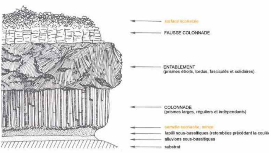
Il y a 7 millions d’années, sur les terres d’Ardèche se trouvait de nombreux volcans. Ces derniers étaient en forte activité. Des coulées de laves ont donc construit le paysage tel que nous le voyons aujourd’hui…
A Mirabel, le Plateau du Coiron s’est formé suite à ces éruptions volcaniques. A l’époque le Plateau était traversé par une rivière et les coulées de laves ont emprunté le lit de cette rivière et celui de ses affluents. Les coulées ont une structure horizontale et reposent sur des formations sédimentaires marno-calcaires datées entre le Jurassique supérieur (130 Ma) et le Crétacé inférieur (110Ma). Ces formations sédimentaires ont été inclinées par la tectonique vers le Sud-est avant l’épisode volcanique.
Lorsque la lave refroidie, elle forme des colonnes de basalte en formant des prismes plus ou moins réguliers que l’on nomme « orgue basaltique ».
Source:
https://www.rando-pedestre-chabeuil.fr › download › Le basalte et Mirabel
▪︎Envoyez-moi vos propositions de réponses soit via mon profil (BruKan), soit via la messagerie geocaching.com (Message Center), et je vous contacterai en cas de problème.
▪︎Loguez cette cache "Found it" !
⚠️ Les logs enregistrés sans réponses seront supprimés.
Au WP1:
N 44° 36.535 E 004° 29.831
1/ Expliquez, selon vous, pour quelle raison ce matériau a été utilisé pour la construction du donjon ?
2/ Avec le basalte, une autre roche est visible sur la tour. Laquelle est-ce ?
Sur quelle partie de la tour est-elle visible ?
Donnez les raisons de son utilisation ?
Au WP2:
N 44° 36.560 E 004° 29.930
3/ Quel type de roche se présente face à vous ?
Quel nom lui donne-t-on lorsqu'il apparaît de cette manière ?
Au WP3:
N 44° 36.552 E 004° 29.921
Joignez à votre log une photo de vous ou de votre GPS, tel que vous le voyez ci-dessous !
Village of MIRABEL
Mirabel means "the place where the view is beautiful".
From the village the view embraces the massif du Coiron, the Cevennes and the plain to the rock of Sampzon.
The village of Mirabel developed at the foot of the castle of the same name that appears in the course of the twelfth century. From the castle, there remains only the dungeon probably dating from the twelfth century. It is one of the few still well preserved in Ardèche since it is complete to its summit.
The fortifications of the village are still visible with its 6 towers of the late Middle Ages.
In 1628, Protestants holding the stronghold of Mirabel are dislodged by the armies of Richelieu who put the siege in front of the castle while destroying Privas.
In the commune of Mirabel extend the lands of the Pradel estate belonging to Olivier de Serres, precursor agronomist of the early 17th century who made it a field of experimental crops.
The Tower of Mirabel is the only vestige of these ancient fortifications which managed to pass through the wars of religion. Indeed, in June 1628, the men of Montmorency destroyed all the fortifications leaving only the tower. The fortified complex was in fact made up of two castles: one Catholic belonging to the lords of La Roche des Astars, the other to the Protestant lords of Arlempdes. The first castle, dismantled in the seventeenth century retains only a few sections of walls found low (digs + reconstruction) by its new owner from 1970. The second castle, also destroyed, yet kept its square keep. It is built of black basalt rubble and has its links in limestone clear, which gives it its original appearance.
Geology :
7 million years ago, on the Ardèche lands were many volcanoes. These last were in strong activity. Lava flows have built the landscape as we see it today ...
In Mirabel, the Coiron Plateau was formed following these volcanic eruptions. At the time the Plateau was crossed by a river and the lava flows have borrowed the bed of this river and that of its tributaries. The castings have a horizontal structure and are based on marl-limestone sedimentary formations dated between the Upper Jurassic (130 Ma) and the Lower Cretaceous (110 Ma). These sedimentary formations were inclined by tectonics to the southeast before the volcanic episode.
When the lava cooled, it forms basalt columns forming more or less regular prisms that is called "basaltic organ".
Source:
https://www.rando-pedestre-chabeuil.fr › download › Le basalte et Mirabel
▪︎Send me your suggested answers either via my profile (BruKan) or via geocaching.com (Message Center), and I will contact you in case of problems.
▪︎Log this cache "Found it" !
⚠️ The logs recorded without answers will be deleted.
At WP1:
1/ Explain, in your opinion, why this material was used for the construction of the dungeon?
2/ With basalt, another rock is visible on the tower. Which is it?
On which part of the tower is it visible?
Give the reasons for its use?
At WP2:
3/ What kind of rock is in front of you? What name do you give him when he appears this way?
At WP3
N 44° 36.552 E 004° 29.921
Attach to your log a photo of you or your GPS, as you see below !