Les textes sur le terrain sont écrits en français et en anglais.
The texts in the field are written in French and in English.
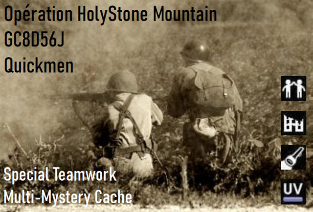
Opération HolyStone Mountain
Septembre 1944. La Belgique est envahie par l'Allemagne, mais la libération est proche.
Une opération du nom de "HolyStone Mountain" est montée conjointement entre la Résistance Belge et les Américains afin de reprendre le contrôle de la position fortifiée de Liège.
Pour ce faire, il a été décidé que deux hommes pénétreront furtivement dans le fort d'Eben-Emael, là où se trouve le centre de communications principal permettant aux forts de communiquer entre eux.
Un Résistant, pour sa bonne connaissance du terrain, ainsi qu'un Américain, pour sa maîtrise des explosifs.
Leur mission est de faire exploser ce centre de communications.
Ensuite, tous les forts pourront être attaqués les uns après les autres...
September 1944. Belgium is invaded by Germany, but the liberation is near.
An operation called "HolyStone Mountain" was mounted jointly between the Belgian Resistance and the Americans to regain control of the fortified position of Liege.
To do this, it was decided that two men will sneak into the Eben-Emael fort, where the main communications center is located, allowing the forts to communicate with each other.
A Resistant, for his good knowledge of the field, as well as an American, for his mastery of explosives.
Their mission is to blow up this communications center.
Then all the forts can be attacked one after the other ...
"Soldats, me recevez-vous ?
Ici le général Victor Igenère, c'est moi qui vais diriger l'opération.
Je vous communiquerai les informations nécessaires au fur et à mesure des missions qui composeront cette opération.
Jean, ton nom de code sera "BlackWolf", John ton nom de code sera "BlueBear".
Il est impossible d'approcher le fort d'Eben-Emael sans se faire voir, mais pourtant, trois Résistants avaient découvert un passage non surveillé.
Malheureusement, ils se sont fait tuer avant de pouvoir nous communiquer comment accéder à ce passage...
Franchissez discrètement le canal Albert, et rendez-vous aux coordonnées suivantes :
UCCBUBBDDQFIQXGZRZEFYLKSFIBHJBBNBMLFZQAQHESUG
LGEXWKCMIDCWVGQLRNFPQINOGVQIHCHIVGKSFVLKCVWCIUGKE
Entrez ces coordonnées dans le geocheck, je vous y donnerai les objectifs de votre première mission.
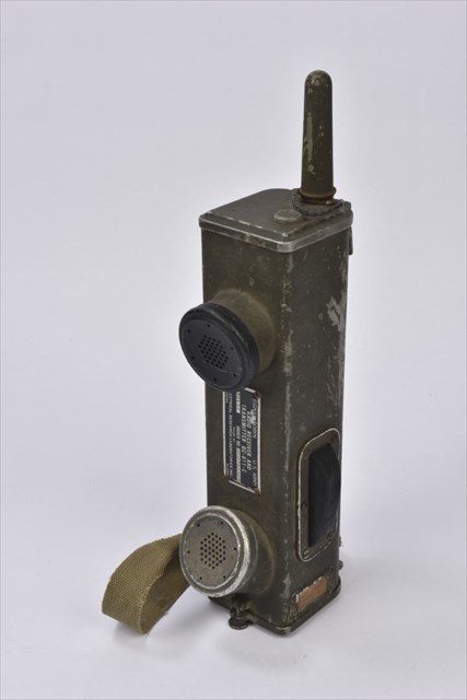
N'oubliez pas de prendre vos talkies walkies pour pouvoir communiquer entre vous.
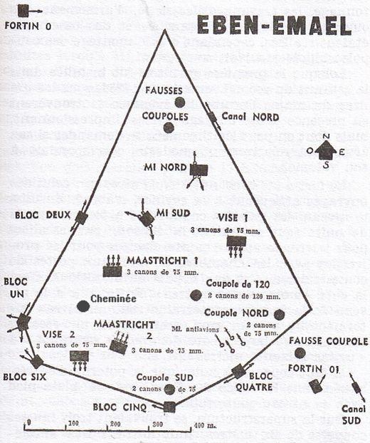
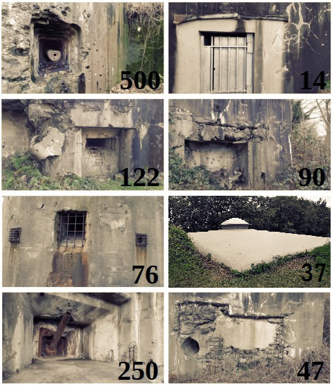
Pensez également à emporter la carte du fort et le document d'identification des bunkers se trouvant ci-dessous.
Allez soldats, en avant, le peuple compte sur vous !"
"Soldiers, do you receive me?
Here, General Victor Igenere, I will lead the operation.
I will give you the necessary information as and when the missions that make up this operation.
Jean, your code name will be "BlackWolf", John your code name will be "BlueBear".
It is impossible to approach the fort of Eben-Emael without being seen, but nevertheless, three resistance fighters had discovered an unguarded passage.
Unfortunately, they were killed before telling us how to access this passage ...
Cross discreetly in the Albert canal and go to the following coordinates:
UCCRZYWIILSLBWEOELSDDGNFFIHSHCHIVGGSCMKBLGLDSY
LODRRXFBDQFISBVMQLUCCWLTBYDCHRIOQAAHHMLAFRIRCOE
Enter these coordinates in the geocheck, I will give you the objectives of your first mission.
Do not forget to bring your talkies-walkies to communicate with each other.
Also remember to take the fort map and the bunkers identification document below.
Go soldiers, go ahead, people are counting on you !"
Sur le terrain, cette aventure devra être parcourue par au moins deux personnes qui par moment devront s'entraider à distance via des itinéraires séparés. Pour ce faire, chaque personne/groupe aura besoin d'un smartphone avec du crédit d'appel et du data, ainsi que d'une lampe UV et d'une lampe torche. Par contre, une seule boussole suffira.(Une VRAIE boussole, pas de signal GPS) Des feuilles quadrillées pourraient être aussi utiles.
D'une longueur de 8km, le circuit ne comporte pas de difficultés majeures, hormis un long passage dans le noir complet. Pensez à porter un pantalon, certains endroits pouvant êtres piquants.
Comptez entre 5 et 8 heures pour terminer cette aventure dont certaines missions peuvent s'avérer assez difficiles.
Bon amusement et bonne chance dans vos missions ! ;)
In the field, this adventure will have to be covered by at least two people who will at times have to help each other at a distance via separate routes. To do this, each person/group will need a smartphone with call credit and data, as well as a UV lamp and a flashlight. However, a single compass (A REAL compass, no GPS signal) Grid paper might be useful too.
With a lenght of 8 km, the circuit does not cause any major difficulties, except a long passage in total darkness. Put on pants, some places can sting.
Count between 5 and 8 hours to complete this adventure which some missions can be quite difficult.
Good fun and good luck in your missions! ;)
Si vous le souhaitez, une fois la cache loguée, vous pouvez afficher cette bannière sur votre profil :
If you wish, once the cache is logged, you can display this banner on your profile:
<p style="text-align:center">
<span style="color:#800000; font-size:large"><a href="https://coord.info/GC8D56J" target="_blank"><img alt="" src="https://img.geocaching.com/cache/large/05f3589a-059e-4c03-b63e-b774e5470c0f.png?rnd=0.5697122" style="height:420px; width:640px" /></a></span>
</p>