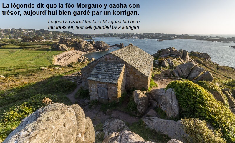

click on the flag to reach the translation
Une Earthcache
Il ne s’agit pas d’une cache physique. Pour loguer cette cache, vous devez dans un premier temps prendre connaissance de sa description éducative en matière de géologie, puis d’observer le site sur lequel vous êtes, et enfin de répondre aux questions qui vous seront posées.
Vous pourrez alors loguer en "Found it" sans attendre mais vous devez me faire parvenir vos réponses en même temps en me contactant soit par mail dans mon profil, soit via la messagerie geocaching.com (Message Center), et je vous contacterai en cas de problème. Les logs enregistrés sans réponses seront supprimés.

Un peu de géologie
La région géologique de St Jean du Doigt
Saint-Jean-du-Doigt est localisée à l'extrémité occidentale du domaine nord armoricain, dans le Massif armoricain qui est le résultat de trois chaînes de montagne successives.
L'histoire géologique de la région est marquée par le cycle hercynien, qui a débuté au Dévonien et s'est terminé avec le Permien, soit entre 420 et 250 millions d’années. Les roches se sont alors formées par métamorphisme et magmatisme : le chapelet nord de granites rouges tardifs (dite ceinture batholitique), forme de Flamanville à Ouessant un alignement contrôlé par les grands accidents directionnels WSW-ENE, datés de 300 millions d’années.
La formation de cette chaîne de montagne affecte aussi tout le domaine ouest-breton. À ce processus, sont associées l'ouverture du bassin de Morlaix et la mise en place du Petit Trégor : gabbro de Saint-Jean-du-Doigt, métadolérites de Barnenez et amphibolites de Plestin.

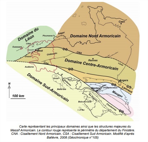
Le Finistère et le Massif Armoricain
Le Massif Armoricain s’est structuré par épisodes géologiques successifs. Depuis le Protérozoïque supérieur (650 millions d’années), le Massif Armoricain a été soumis, au moins par deux fois, à des phénomènes tectoniques ayant engendré la formation de chaînes de montagne (orogenèses « cadomienne » et « hercynienne »).
Ce massif est divisé en grands domaines (Les domaines Nord-Centre-Sud Armoricains), séparés les uns des autres par deux zones de cisaillement majeures que sont : le Cisaillement Nord Armoricain (CNA) et le Cisaillement Sud Armoricain (CSA). Dans la partie Nord du Massif Armoricain, peut être isolé un « sous domaine » qu’est le domaine du Léon. Le Finistère se situe dans la partie occidentale du Massif Armoricain.
Questions
Le fil de l'observation que je vous propose va vous permettre de comprendre la formation du phénomène que vous voyez devant vous
Q0 - Prenez une photo de vous, ou de votre objet distinctif de géocacheur, ou de votre pseudo écrit sur une feuille de papier ou dans votre main... devant l'écueil, et joignez-là à votre log ou à vos réponses
Q1 - L'écueil est séparé du reste de la pointe (faites attention en vous penchant). Décrivez l'espace entre les deux que vous avez devant vous en termes de formes (verticalité, forme, distance, géométrie remarquable...)
Q2 - Et également en termes de roches (vous observez une roche ou plusieurs roches, surface, couleur...). Comparez également le caractère plus ou moins massif entre les roches que vous observez en contre bas et celles que vous observez derrière vous (direction sud) vers le "sommet". Vous pouvez prendre appui pour votre observation sur cette partie:
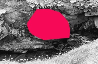
Q3 - Prenez une boussole, quelle est l'orientation de cet espace entre la pointe et l'écueil ?
D’après votre observation et les éléments structuraux du cours de géologie ci-avant
Q4 - Comment s'est formé cet espace entre l'écueil et le reste de la pointe ? Je vous donne pour cela plusieurs hypothèses, il vous faudra justifier celle que vous retenez
- Eloignement - L'écueil s'est progressivement éloigné au cours des millénaires du reste de la pointe par un phénomène lié à la mer
- Erosion - Une state sédimentaire existait entre ce qui est aujourd'hui l'écueil et le reste de la pointe, l'érosion l'a faite disparaître ce qui a créé cet espace visible aujourd'hui
- Glissement - Du fait d'une faille géologique, la roche qui était au niveau de cet espace a glissé et a été ensevelie plus profondément
- Autre - La mythologie est florissante en Bretagne, Arthur aurait fendu ici la roche avec Excalibur pour emprisonner par ce gouffre mouvementé la fée Morgane qui s'est alors retrouvée isolée sur l'écueil

An Earthcache
It is not a physical cache. To log this cache, you must first learn about its educational description in geology, then observe the site on which you are, and finally answer the questions that will be asked.
You can then log in "Found it" without waiting but you must send me your answers at the same time by contacting me either by mail in my profile, or via the messaging geocaching.com (Message Center), and I will contact you in case of problem. Saved logs without answers will be deleted.
A little of geology
The geological region of St Jean du Doigt
Saint-Jean-du-Doigt is located at the western end of the north Armorican domain, in the Armorican Massif which is the result of three successive mountain ranges.
The geological history of the region is marked by the Hercynian cycle, which began in the Devonian and ended with the Permian, between 420 and 250 million years ago. The rocks were then formed by metamorphism and magmatism: the northern chain of late red granites (known as the batholithic belt), form from Flamanville to Ouessant, an alignment controlled by the major directional accidents WSW-ENE, dated 300 million years.
The formation of this mountain chain also affects the entire area of West Brittany. In this process, the opening of the Morlaix basin and the setting up of Petit Trégor are associated: Saint-Jean-du-Doigt gabbro, Barnenez metadolérites and Plestin amphibolites.
Finistère and the Armorican Massif
The Armorican Massif has been structured by successive geological episodes. Since the Upper Proterozoic (650 million years ago), the Armorican Massif has been subject, at least twice, to tectonic phenomena that have led to the formation of mountain ranges ("Cadian" and "Hercynian" orogenies).
This massif is divided into large domains (the North-Center-South Armorican domains), separated from each other by two major shear zones that are: the North Armorican Shear (CNA in the picture) and the South Shear Armorican (CSA in the picture). In the northern part of the Armorican Massif, can be isolated a "subdomain" that is the domain of Leon. Finistère is located in the western part of the Armorican Massif.
Questions
The line of observation that I propose will allow you to understand the formation of the phenomenon that you see before you
Q0 - Take a picture of yourself, or your distinctive geocacher object, or your nickname written on a piece of paper or in your hand... in front of the reef, and attach it to your log or your answers
Q1 - The reef is separated from the rest of the pit(be careful when leaning). Describe the space between the two that you have in front of you in terms of shapes (verticality, shape, distance, remarkable geometry ...)
Q2 - And also in terms of rocks (you observe a rock or several rocks, surface, color ...). Also compare the more or less massive character between the rocks you observe below and those you observe behind you (south) towards the "summit". You can take support for your observation on this part:
Q3 - Take a compass, what is the orientation of this space between the tip and the reef?
From your observation and the structural elements of the geology course above
Q4 - How was this space formed between the reef and the rest of the pit? I give you several hypotheses, you will have to justify the one you keep
- Removing - The reef has progressively moved away over the millennia from the rest of the pit by a phenomenon related to the sea
- Erosion - A sedimentary state existed between what is today the reef and the rest of the pit, erosion makes it disappear which created this visible space today
- Sliding - Due to a geological fault, the rock that was at this space slipped and was buried deeper
- Other - Mythology is flourishing in Brittany, Arthur would have split the rock here with Excalibur to imprison by this animated chasm the fairy Morgane who then found herself isolated on the stumbling block