Vlkolínec UNESCO
 Rezervácia ľudovej architektúry Vlkolínec bola zapísaná do Zoznamu svetového dedičstva UNESCO ako kultúrne dedičstvo v roku 1993 v Cartagene v Kolumbii na základe kritérií iv) a v). Kritérium iv) znamená, že Vlkolínec predstavuje typ dedinského sídla s drevenou architektúrou horských a podhorských oblastí s nenarušenou zástavbou zrubových domov uprostred krajiny s poľami a pasienkami. Je to v rámci karpatského regiónu najlepšie zachované sídlo svojho druhu; kritérium v) znamená, že lokalita je výnimočným príkladom tradičného ľudského osídlenia a využitia pôdy, ktoré je reprezentatívne v danej kultúre, najmä ak ide o prípad zraniteľný v dôsledku vplyvu nezvratných zmien. Ide o súbor 45 budov s mnohými jedinečnými konštrukčnými osobitosťami.
Pamiatková rezervácia Vlkolínec je osada, ktorá tvorí mestskú časť Ružomberka, napriek tomu, že je od neho úplne oddelená. Leží vo vzdialenosti okolo 7 km južne od mesta v Národnom parku Veľká Fatra, vo vnútorných Západných Karpatoch. Dominantou územia je prírodná scenéria s najvyšším končiarom ─ vrchom Sidorovo (Hýrová, Žiar) s nadmorskou výškou 1 099 m. Vlkolínec sa nachádza na jeho úpätí vo výške 718 m. n. m. Do osady sa môžeme dostať z cesty Ružomberok – Banská Bystrica cez obec Biely Potok.
Osada sa prvýkrát spomína nepriamo v listine kráľa Ľudovíta I. z roku 1376. Osídlenie na tomto mieste však bolo už od pradávna. V bezprostrednom okolí obce sa našli stopy osídlenia z 10. ─ 12. storočia. Dejiny obce v období stredoveku sú späté s jeho vzťahom k Likavskému a Ružomberskému panstvu. Názov obce Vlkolínec je pravdepodobne spojený s povinnosťou obyvateľov udržiavať „vlčie diery“ (nariadenie z roku 1625).
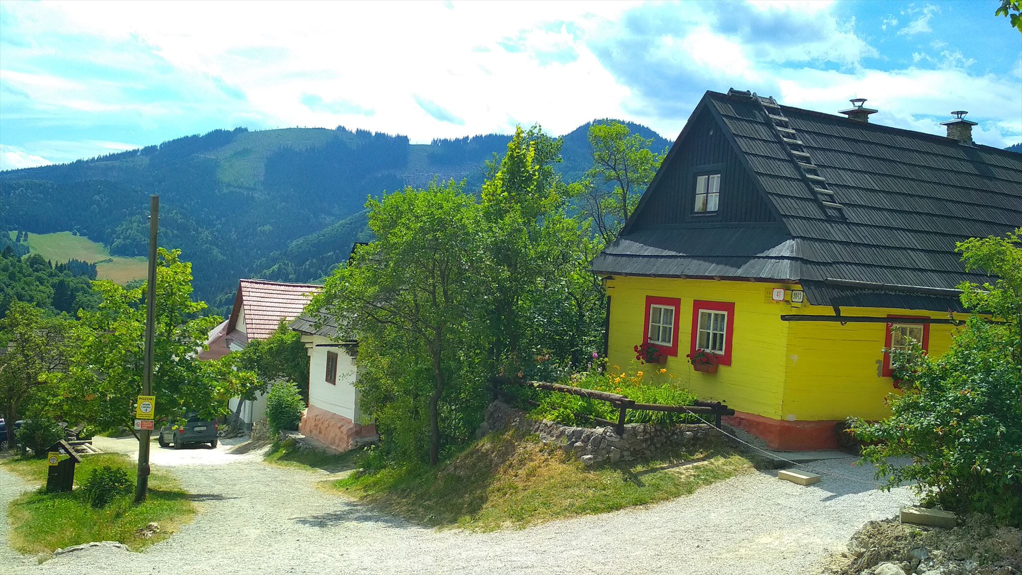
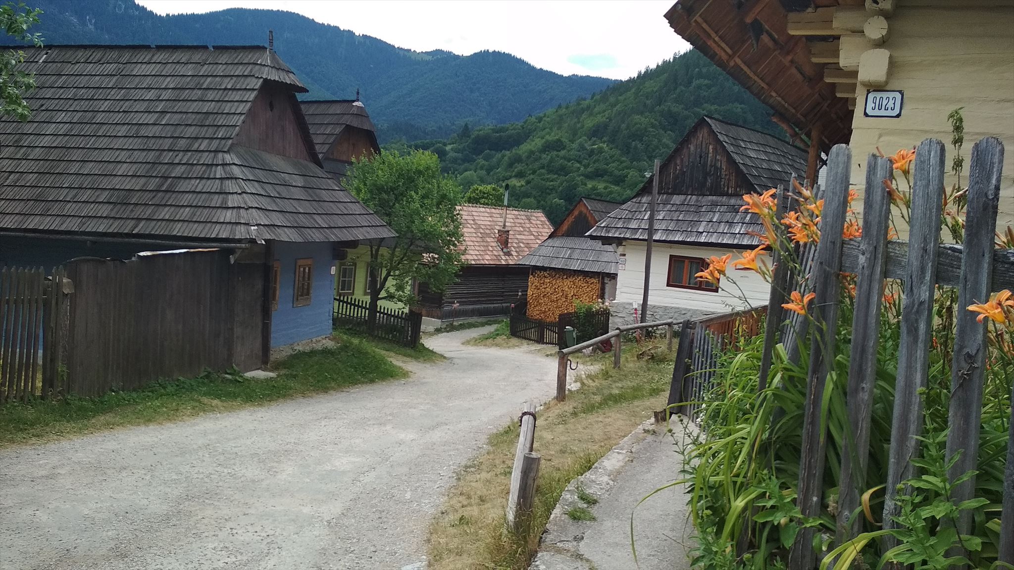
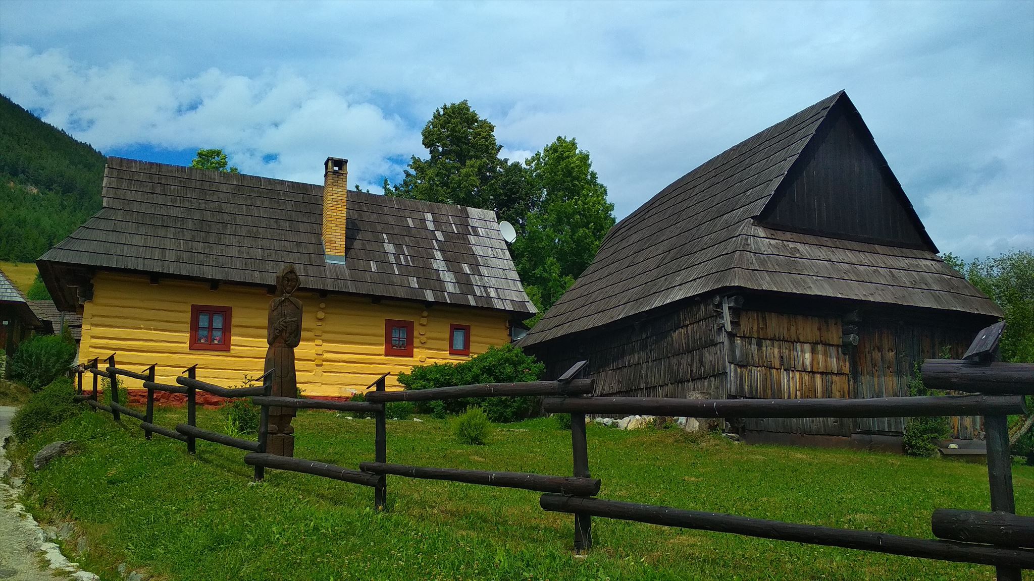
Obec Vlkolínec bola vždy spojená s využívaním lúk, pasienkov a úzkych políčok, na ktorých sa pestovali základné poľnohospodárske plodiny a chovali hospodárske zvieratá. Obyvatelia sa zaoberali poľnohospodárstvom, pastierstvom, chovom dobytka a drevorubačstvom. I dnes je úzko spätá s okolitou krajinou, nesúcou črty minulosti. Je to hromadná obec s dlhými hlbokými dvormi, spoločnými pre niekoľko obytných domov. Vďaka periférnej polohe a čiastočnej izolovanosti zostal zachovaný nielen historický ráz sídla a okolitej prírody, ale aj vonkajší vzhľad objektov ľudovej architektúry, ako aj vnútorné usporiadanie väčšiny domov. V pravidelnej radovej zástavbe po oboch stranách kľukatej cesty a potoka sú postavené obytné domy s hospodárskym zázemím.
Ľudový dom patrí k typu stredoslovenského zrubového domu. Usadlosť zvyčajne tvorí dom, maštaľ a drobnejšie hospodárske stavby vzadu so stodolou. Zrubové drevené obytné domy s kamenným soklom majú sedlové strechy pokryté šindľom, ktorých štíty sú zakončené polkružím. Steny domov sú zatreté hlinou a obielené vápnom s rôznymi farebnými odtieňmi. Do domu, ktorý je zvyčajne trojpriestorový, sa vstupuje z dvora. Na vykurovanie slúži pec s ohniskom v zadnej časti pitvora. Väčšina dnešných domov sú z polovice 19. storočia.
Okrem domov, hospodárskych budov, maštalí a drevární v obci nájdeme aj senníky, sýpky a komory.
V centre obce sa uprostred tradičnej zástavby zachovala zvonica z roku 1770, pokrytá šindľom a zakončená krížom, ktorej funkciou bolo oznamovať čas modlitieb. Zvonením sa ohlasovali aj požiare a iné nebezpečenstvo.
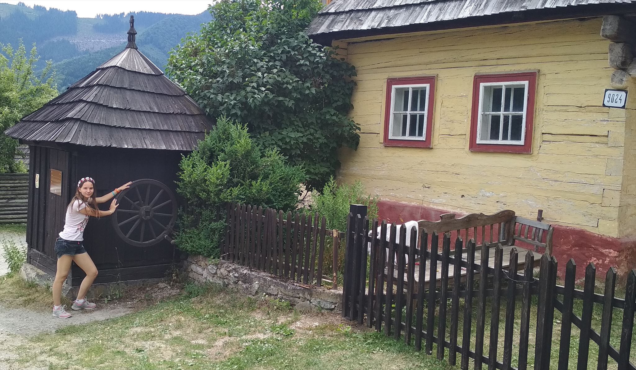
V obci sa ďalej nachádza rumpáľová studňa – zdroj pitnej vody, ktorá je 12 metrov hlboká. Ku kamenným stavbám patrí Kostol Navštívenia Panny Márie, postavený v roku 1875, prestavaný z kaplnky. Je to jednoloďová stavba s presbytériom a do priečelia vstavanou vežou. Dodnes patrí k najvýznamnejším miestam spoločenských kontaktov obyvateľov aj návštevníkov Vlkolínca. Po pravej strane cesty k cintorínu a kostolu sa nachádza murovaná budova bývalej školy z konca 19. storočia, citlivo osadená do prostredia.
Oproti kostolu je cintorín s množstvom zaujímavých náhrobných krížov. Stredom obce preteká potok usmernený do drevených žľabov. Neoddeliteľnou súčasťou obce sú úzke parcely zo zástavby prechádzajúce do záhrad a terasovitých políčok so senníkmi, harmonicky začlenených do okolitej krajiny.
Vlkolínec nie je skanzen ani múzeum, je to živá obývaná dedina. Ľudia tu žijú a pracujú. Na vlkolínskych prielohoch a pastvinách sa pasie dobytok.
Je to pozoruhodne intaktne zachovaný sídelný celok, patriaci k typu stredoeurópskych sídel s drevenou zrubovou architektúrou, rozšírených v horských a podhorských oblastiach. Urbanisticky prešiel iba nepatrnými zmenami, predstavuje najzachovanejší a najucelenejší urbanistický celok pôvodných ľudových stavieb v širokom kontexte okolitých krajín.
ÚLOHA
Stage1: Tu sa nachádza drevená rumpáľová studňa. Vytvorte fotografiu seba, ako na nej krútite kolesom.
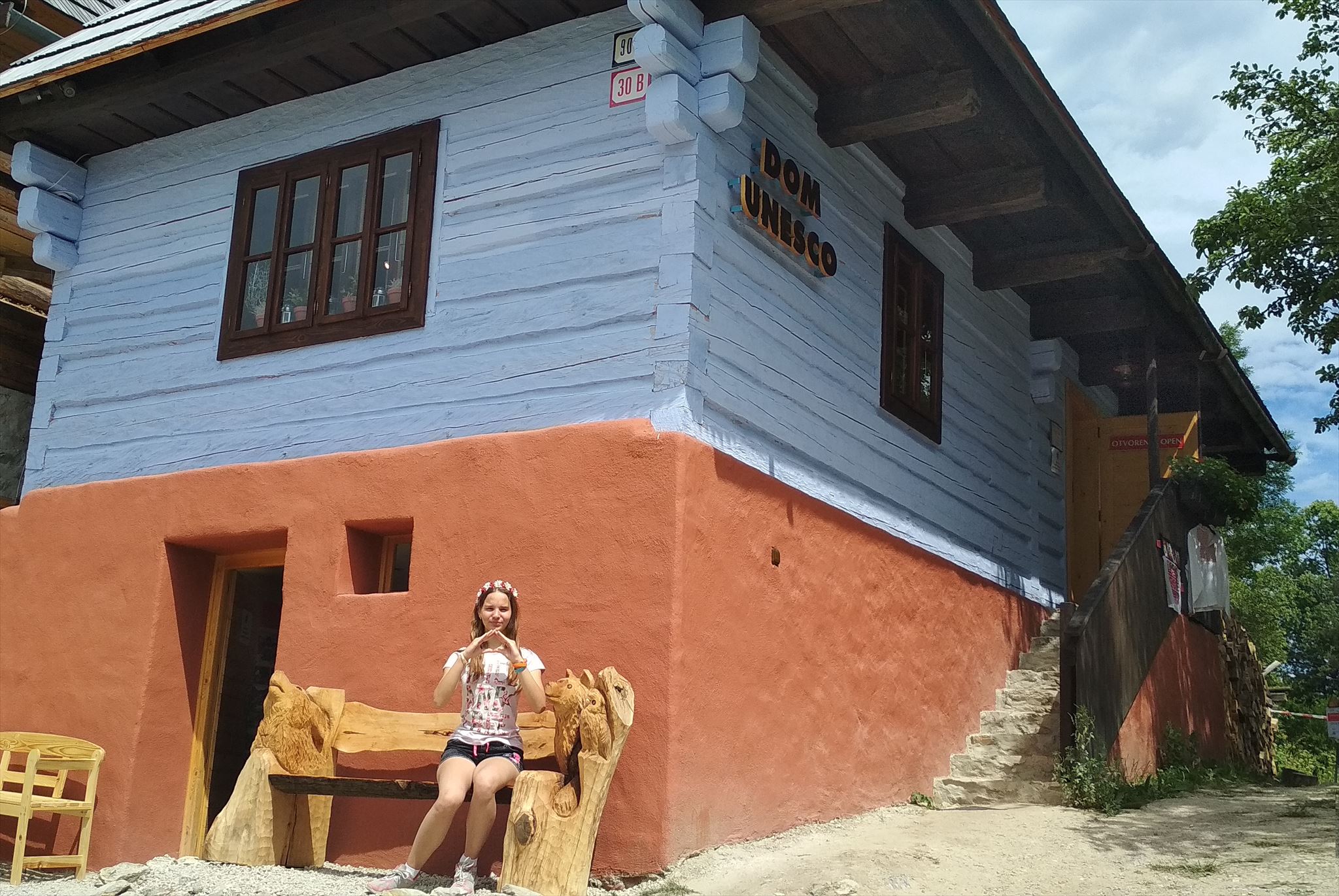
Stage2: Tu je dom UNESCO. Aj tu urobte fotografiu seba s domom v pozadí. No a kedže je to UNESCO, skúste rukami vytvoriť striešku ako na tunajších dreveničkách  .
.
UPOZORNENIE
Na súradniciach nehľadajte žiadnu fyzickú kešku, tá tu nie je. Potrebné sú ale minimálne dve fotografie, jedna pri zrubovej studni a druhá pri dome UNESCO. Bez nich a bez týchto jednoduchých úloh, budeme musieť váš log vymazať. Skupinové fotografie neakceptujeme, každý nick musí mať svoje vlastné fotky.
Ilustračné fotografie / Illustration photos :)
 Folk architecture reservation Vlkolínec Village was entered in the List of the UNESCO World Heritage List at Cartagena (Columbia) in 1993, based on the criteria (iv) and (v). Criterion (iv) means that Vlkolínec represents a type of rural settlement which features the wooden architecture of mountain and sub mountain areas with the intact fabric of log cabins amidst a landscape of fields and pastures. It is the best conserved settlement of its kind in the Carpathian Region. Criterion (v) means that the locality is a rare example of traditional human settlement and land use which is representative of the given culture, and potentially vulnerable to the effects of irreversible change. It is a set of 45 buildings with many unique construction features and elements.
The Vlkolínec Monument Reserve forms part of the city of Ružomberok, in spite of being completely separated from the city. It lies 7 km south of the city in the Veľká Fatra National Park, in the inner Western Carpathians south of the city. The dominant feature of the territory is its natural scenery with the tallest peak of Sidorovo (Hýrová, Žiar, 1,099 metres). Vlkolínec is situated at its foothill at an altitude of 718 metres above sea level. The settlement is accessible from the Ružomberok-Banská Bystrica road via the village of Biely Potok.
The first indirect reference to the village was in a historic document of King Louis (Lajos) I (1326-1382) dating from 1376. However, a settlement is known to have existed here since time immemorial. Traces of settlement from the 10th to 12th centuries have been found in the immediate environs of Vlkolínec. The medieval history of the village is connected with the estates of Likava and Ružomberok. The name Vlkolínec (literally ‘Wolf’s Place’) is probably connected with the duty of villagers to maintains the wolf pits as set out in a regulation dating from 1625.
Life in Vlkolínec was always connected with the use of meadows, pastures and thin stripes of fields where basic farm crops were grown and farm animals were kept. The locals lived off farming, shepherding, cattle raising and logging. Today the village is still closely connected with the surrounding landscape, bearing many features of the past. It is a village with long and deep courtyards, common to several houses. Thanks to its peripheral location and partial isolation, there have survived here not only the historic characteristics of the settlement and the landscape but also the outer appearance of houses and structures, which were built in folk architecture style and have mostly been conserved along with their historic interior furniture and fittings. Residential houses with their economic hinterland (shops) are built in rows on both sides of the winding road and brook.
The local folk house is of a characteristic Central Slovak log cabin type. The homestead normally consists of a house, a stable and tiny shops with a barn located behind. Each log house stands on a stone socle and is covered by a saddleback shingle roof with gables which end in a half-circle decoration. Walls are smeared with clay and painted with lime in various colour hues. A typical three-section house is entered from the courtyard. A stove with a hearth in the back part of the entrance hall provides heating. The majority of houses in Vlkolínec date from the mid-19th century.
Apart from houses, shops, stables and barns there are also haylofts, granaries and pantries/storerooms in the village.
A shingle-covered belfry dating from 1770 and ending in a cross survives in the centre of the village. Its main function was to announce the time of prayers, but the bell also warned of fires and other dangers.
The village also includes a 12 metre-deep well, the source of drinking water.
Among the stone buildings is the Church of the Visitation of the Virgin Mary, rebuilt from an earlier chapel in 1875. It is a single-nave structure with a presbytery and an in-built tower. It is still the most important place for social interaction between the villagers and visitors to Vlkolínec. On the right side of the road leading to the cemetery and the church, charmingly sited in a natural setting, is a brick former school building which dates from the end of the 19th century.
Opposite the church is the cemetery with a number of interesting tomb crosses. A brook set in wooden troughs flows through the centre of the village. Scattered throughout the surrounding area are various types of wooden haylofts, stables, barns, granaries and lattice fences.
Vlkolínec is not an open-air museum. It is a live settlement where people live and work, where cattle graze in meadows and pastures.
Vlkolínec is a remarkably well-conserved and intact example of a Central European mountain and sub mountain region settlement. It has been subject to few changes and represents the best-preserved and complete set of original folk structures in a wider context of the surrounding countryside.
Vlkolínec is a remarkably well-conserved and intact example of a Central European mountain and sub mountain region settlement. It has been subject to few changes and represents the best-preserved and complete set of original folk structures in a wider context of the surrounding countryside.
THE TASK
Stage1: Here is a wooden winch well. Take a photo of yourself twisting the wheel on it.
Stage2: Here is a UNESCO house. Also take a photo of yourself with the house in the background. And since it is a UNESCO World Heritage Site, try to create a roof like a wooden house.
CAUTION
Do not look for any physical cache in the coordinates, it is not here. However, at least two photographs are needed, one at the log well and the other at the UNESCO house. Without them and without these simple tasks, we will have to delete your log. Group photos are not accepted, each nick must have his own photos.
For example, photo is upper.
zdroj/source: https://profil.kultury.sk/sk/
Fotografie: binkáči
Virtual Rewards 2.0 - 2019/2020
This Virtual Cache is part of a limited release of Virtuals created between June 4, 2019 and June 4, 2020. Only 4,000 cache owners were given the opportunity to hide a Virtual Cache. Learn more about Virtual Rewards 2.0 on the Geocaching Blog.