“The Waterpark Capital of the World” is a tourist town pretty much everyone in Wisconsin has visited at least once. I have been coming here for the last 40 years, and have visited nearly all of the 20 square miles of amusement parks, cheap motels and high end resorts at one point or another. Wisconsin Dells is dripping in roadside Americana kitsch: water parks, go cart rides, souvenir shops, fudge stores and lots of tourists. But all of this gaudy stuff is not the real Wisconsin Dells.
Tourism started here back in the 1800’s when H.H. Bennett published a stop action photo of his son Ashley leaping to Stand Rock in 1886. The picture is iconic, and the studio that Bennett founded in 1865 is still here in Wisconsin Dells.
After World War II, army surplus land and water vehicles, known as “Ducks” were first brought into Lake Delton by Mel Flath. He operated a tourist trip from the present Mexicali Rose into the Wisconsin River to see the Dells. Later, an early version of the Tommy Bartlett water ski show in the 1950s changed tourism in the Dells away from just enjoying nature.
In 1978, Family Land, now Mt. Olympus Water & Theme Park opened in Wisconsin Dells. A year later, Noah’s Ark opened. Over the years several other water parks have opened, making the Wisconsin Dells,“The Waterpark Capital of the World.”
Most people visiting the Wisconsin Dells today totally overlook the natural beauty of the area, that brought tourism here in the first place. This virtual cache is meant to get you away from the tourist traps for an hour or so and into the beautiful nature that is still here and still protected.
Nearly all of the land surrounding the Wisconsin River and the beautiful canyons carved by water erosion has been preserved by the Wisconsin DNR, and is part of a State Natural Area. This virtual cache takes you on a 1.8 mile hike into the The Dells of The Wisconsin SNA. The Chapel Gorge hiking trail, just south of Chula Vista, blazes through hardwood and Norway pine forest going west to the Wisconsin River. This easy two track walking trail eventually leads to a secluded natural beach at the point where the Wisconsin River exits The Narrows. The beach is perfect for swimming and for seeing the real Wisconsin Dells. This is the original Wisconsin Dells attraction: Nature.
If you want to swim, be sure to bring your swimsuit, as swimming is allowed here. If you decide to swim while here bring your life jacket also because drop-offs and currents can be unpredictable on the the river. You will see the Wisconsin River, and to the north of the beach the Narrows, which is said to be 52 feet wide and 150 feet deep. In the summer, you will see boatloads of tourists going by this location, a highlight of the boat tours of the Dells.
To claim a find on the virtual, you need to complete two tasks:
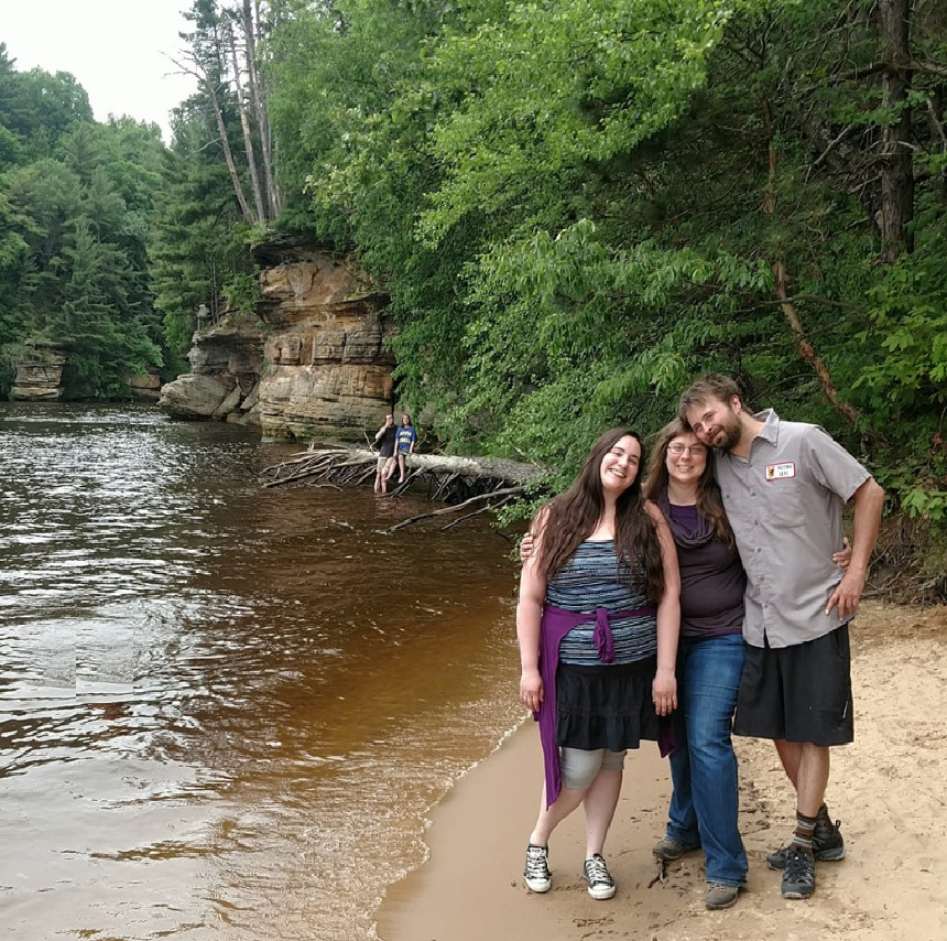
1. At the posted coordinates, take a picture of yourself on the beach with the Narrows to the north in the background, like in the sample picture. It is preferred to have yourself and your caching party in the picture, but that is not required.
2. Go up the hill, a short distance to a series of signs. Please send me a message with how many words are on the sign, not counting the logo. Also include in your message how many steps going up the hill are made of concrete.
Please note that the terrain rating is accurate. Nearly all of the hike out here is near level terrain, either a 1.5 or 2 for a distance of 1.8 miles round trip. However, to get down to the beach, there is a sharp decline with steps that are not well maintained, so there is some more difficult terrain for a very short distance. You need to get the photo on the beach and also count the words on the signs at the top of the cliff.
Approval for placement of this cache was obtained by Thomas Meyer, Conservation Biologist of Wisconsin DNR's State Natural Areas Program. In addition, the Geocache Notification Form was submitted to Thomas Meyer DNR Endangered Resources, PO Box 7921, Madison, WI 53707
Geocaches placed on Wisconsin Department of Natural Resource managed lands require permission by means of a notification form. Please print out a paper copy of the notification form, fill in all required information, then submit it to the land manager. The DNR Notification Form and land manager information can be obtained at: http://dnr.wi.gov/files/PDF/forms/2500/2500-118.pdf
Resources:
https://dnr.wi.gov/topic/Lands/naturalareas/index.asp?SNA=283
https://www.wisdells.com/Articles/A-Walk-Make-That-Slide-Down-Memory-Lane--Wisconsin-Dells.htm
https://hhbennettstudio.wisconsinhistory.org/take-the-leap/
https://wisconsinsbeauty.com/hiking-the-chapel-gorge-trail/
Virtual Rewards 2.0 - 2019/2020
This Virtual Cache is part of a limited release of Virtuals created between June 4, 2019 and June 4, 2020. Only 4,000 cache owners were given the opportunity to hide a Virtual Cache. Learn more about Virtual Rewards 2.0 on the Geocaching Blog.