Skip to content

Ponto mais alto do RS [Monte Negro] Traditional Geocache

Hidden : 5/21/2019
Difficulty:
2 out of 5
Terrain:
3 out of 5

Size: Size:   regular (regular)

Join now to view geocache location details. It's free!

Watch

How Geocaching Works

Please note Use of geocaching.com services is subject to the terms and conditions in our disclaimer.

Geocache Description:


monte negro


PONTO MAIS ALTO DO RS [MONTE NEGRO]

Português

O pico do Monte Negro é o ponto mais alto e frio do Rio Grande do Sul, no município de São José dos Ausentes, e atinge os 1403 m de altitude.
Ao lado do pico está o cânion Monte Negro, com os seus 700 m de profundidade a uma altitude média de 1300 m e uma extensão de 4 km, mais uma maravilha da região de Campos de Cima da Serra.

Para chegarem a este local de acesso gratuito, aconselho a estadia em Silveira, de onde poderão chegar facilmente por estrada de chão com um veículo normal.

A cache encontra-se em propriedade privada, mas com permissão do proprietário para chegar ao cimo do pico. Deixo o ponto de referência para o melhor acesso ao pico. A subida não é muito exigente, pelos trilhos deixados pelo gado, e faz-se em menos de 15 minutos. A descida pode ser efetuada pelo menos trajeto ou, para os mais aventureiros, pelo lado oeste, até ao local de estacionamento.

A melhor altura do dia para visitar os cânions e o pico é de manhã, pois de tarde a neblina costuma erguer-se desde o mar e diminuir drasticamente a visibilidade.

O contentor é de tamanho normal e tem elementos para troca.
Deixem as vossas fotos e desfrutem desta maravilha da Natureza!

(Um agradecimento especial ao Pablo, da estância do Tio Tonho, pelas dicas valiosas! Abraço!)


canion
(Vista do ponto zero)

English


The peak of Monte Negro is the highest and coldest point of Rio Grande do Sul, in the municipality of São José dos Ausentes, and reaches 1403 m of altitude. Next to the peak is Monte Negro canyon, with its 700 m depth at an average altitude of 1300 m and an extension of 4 km, another marvel of the region of Campos de Cima da Serra.

To reach this free access point, you can stay at Silveira, from where you can easily reach this place via dirt road with a normal vehicle.

The cache is found in a private property, but the owner allows people to reach the top of the peak. I left the reference point for the best access to the peak. The climb is not demanding, via the tracks left by the cattle, and it is done in less than 15 minutes. The descent can be done through the same route or, for the more adventurous, the west side, to the parking place.

The best time of day to visit the canyons and peak is in the morning as the fog usually rises from the sea and drastically reduces visibility.

The container is of normal size and has somes exchange items.
Share your photos and enjoy this wonder of Nature!

(A special thanks to Pablo, from Tio Tonho's stay, for the valuable tips! Hugs!)


canion
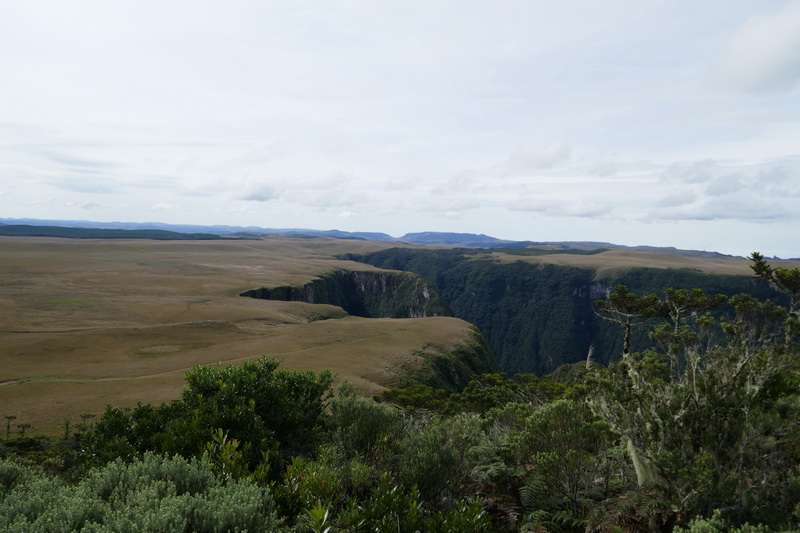
(View from ground zero)


Additional Hints (Decrypt)

CG: Fbo n ebpun tenaqr, pbz ivfgn cnen b pâavba. RAT: Haqre gur ovt ebpx, bireybbxvat gur pnalba.

Decryption Key

A|B|C|D|E|F|G|H|I|J|K|L|M
-------------------------
N|O|P|Q|R|S|T|U|V|W|X|Y|Z

(letter above equals below, and vice versa)