Erg Chebbi Ripple Marks 🐪 علامات النيم عرق الشبي
EN: Ripple Marks | FR: Ride de courant | DE: Rippel | AR: علامات النيم
🌕 Planetary Geology on Earth 🌍
 |
The listed coordinates can be reached on foot, by camel or off-road vehicle.
Some desert camps are nearby.
The ripple marks can also be found elsewhere in the entire Erg Chebbi.
|
 |

EN: Ripple Marks in Erg Chebbi
What are ripple marks?
In geology, ripple marks are sedimentary structures and indicate agitation by water or wind. They usually have flat windward and steeper leeward sides, the arrangement is always transverse to the flow direction. Their size can vary greatly. Seen from above, they can be relatively straight or curved.
How do ripple marks develop?
Ripple marks occur as soon as a current exceeds a critical speed, from which grains of sand are carried along. The starting point is a random unevenness (a small stone or a small accumulation of sand) on which other grains of sand get stuck. This increases the hill steadily. The larger the obstacle becomes, the more grains of sand accumulate. The transport of the grains of sand is carried out by the so-called saltation, which refers to the sudden transport of grains of sand with a grain size of 70-500 microns. When a grain of sand hits the ground, energy is transferred to the surrounding grains of sand, which then jump up and follow a parabolic trajectory. The flow becomes so strong at a certain height at the top of the hill that grains of sand are immediately moved on and the ripple marks are no longer growing. When the first ripple marks have formed, the next grow at a certain distance perpendicular to the flow direction. If the wind does not change, the distance between the ripple marks is also approximately constant, forming a large symmetric pattern of uniform "wavelength".

The following factors influence the aeolian formation of sand ripple marks:
- Wind direction and wind force
- Grain size and moisture of the sand
- Slope of the sand surface / dune
The listed coordinates can be reached on foot, by camel or off-road vehicle. The ripple marks can be also found elsewhere in the entire Erg Chebbi.
Tasks and questions:
1.) Find a surface with uniform ripple marks.
a) How high and how long (wavelength from top to top) are the ripple marks about?
b) From which direction did the wind come, which developed the formation of these ripple marks?
2.) Find another surface with ripple marks that is different in some way from the first.
a) What is the difference between the various ripple marks?
b) In your opinion, which factor has created this difference of the ripple mark formation?
3.) Take a picture in the Erg Chebbi on which you can be seen or your GPS or a personal item and add it to your log .
Please send me the answers via the contact form of my GC profile or the message function. Afterwards you can log directly, you do not have to wait for a log-release. Please don't forget to upload your picture (new log condition).
FR: Ride de courant Erg Chebbi
Que sont les rides de courants?
En géologie, les rides de courants (ou encore des marques d'ondulation), sont des structures sédimentaires qui indiquent une agitation par l'eau ou le vent. Elles ont généralement des flancs du côté sous le vent, et elles sont plates du côté au vent. L’arrangement est toujours transversal au sens de l’écoulement. Leur taille peut varier considérablement. Vus d'en haut, elles peuvent être relativement droites ou courbes.
Comment se développent les rides de courants?
Des rides de courant apparaissent dès qu'un courant dépasse une vitesse critique à partir de laquelle les grains de sable sont entraînés. Le point de départ est une inégalité aléatoire (une petite pierre ou une petite accumulation de sable) sur laquelle d'autres grains de sable se coincent. Plus l'obstacle est grand, plus les grains de sable s'accumulent et forment une coline. Le transport des grains de sable est réalisé par la soi-disant saltation, qui désigne le transport soudain de grains de sable d'une taille de grain de 70-500 microns. Lorsqu'un grain de sable frappe le sol, l'énergie est transférée aux grains de sable environnants, qui sautent ensuite et suivent une trajectoire parabolique. Le flux devient si fort à une certaine hauteur au sommet de la colline que des grains de sable sont immédiatement déplacés et que les rides de courant ne grandissent plus. Lorsque les premières rides de courants sont formées, les suivantes se développent à une certaine distance perpendiculaire à la direction du flux. Si le vent ne change pas, la distance entre les rides de courants est également approximativement constante, formant un grand motif symétrique de "longueur d'onde" uniforme.
Les facteurs suivants influencent la formation éolienne de rides de courant de sable:
- Direction du vent et force du vent
- Granulométrie et humidité du sable
- Pente de la surface de sable / dune
Les coordonnées indiquées peuvent être atteintes à pied, en chameau ou en véhicule tout-terrain. Les rides des courants se retrouvent également ailleurs dans l'ensemble de l'Erg Chebbi.
Tâches et questions:
1.) Trouvez une surface avec des rides de courants uniformes.
a) Quelle est la hauteur et la longueur (longueur d'onde du haut vers le haut) de ces rides?
b) De quelle direction est venu le vent, qui a développé la formation de ces rides?
2.) Trouvez une autre surface avec des rides de courants différente de la première.
a) Quelle est la différence entre les différentes rides?
b) À votre avis, quel facteur a créé cette différence de formation de rides?
3.) Prenez une photo dans l'Erg Chebbi que vous pouvez voir dessus ou sur votre GPS ou un objet personnel et ajoutez-la à votre journal.
Veuillez m'envoyer les réponses via le formulaire de contact de mon profil GC ou la fonction de message. Ensuite, vous pouvez vous connecter directement, vous n'avez pas à attendre la publication du journal. N'oubliez pas de télécharger votre photo (nouvelle condition de journal).
(french translation by oiseau_ca, thanks a lot!)

DE: Rippel in Erg Chebbi
Was sind Rippel?
Rippel oder auch Rippelmarken (in der englischen Sprache bedeutet „ripple“ soviel wie „kleine Welle“ oder „Kräuselung“) sind gleichmäßige wellenförmige Strukturen, die nicht nur in den Flachwasserzonen von Sandstränden auftreten, sondern auch an der Oberfläche von Dünen. Sie besitzen meist flache Luv- und steilere Leeseiten, die Anordnung ist stets quer zur Strömungsrichtung. Ihre Größe kann stark variieren. Von oben betrachtet können sie relativ gerade verlaufen oder geschwungen sein.
Wie entstehen Rippel?
Rippel entstgehen, sobald eine Strömung eine kritische Geschwindigkeit übersteigt, ab der Sandkörner mitgerissen werden. Den Ausgangspunkt bildet eine zufällige Unebenheit (ein kleiner Stein oder eine kleine Sandanhäufung), an der andere Sandkörner hängen bleiben. Dadurch vergrößert sich der Hügel stetig. Je größer das Hindernis wird, desto mehr Sandkörner lagern sich an. Der Transport der Sandkörner erfolgt durch die sogenannte Saltation, die den sprungweisen Transport von Sandkörnern mit einer Korngröße von 70–500 µm bezeichnet. Beim Aufprall eines Sandkornes auf den Boden wird Energie auf die umliegenden Sandkörner übertragen, diese springen dadurch hoch und folgen einer parabelförmigen Wurfbahn. Die Strömung wird ab einer gewissen Höhe an der Spitze des Hügels so stark, dass Sandkörner gleich wieder weiterbewegt werden und die Rippel nicht mehr wächst. Wenn sich die erste Rippel gebildet hat, wachsen die nächsten in gewissem Abstand dazu senkrecht zur Strömungsrichtung. Wenn sich die Strömungsgeschwindigkeit nicht ändert, ist auch der Abstand zwischen den Rippeln ungefähr konstant, sodass sich ein großflächiges symmetrisches Muster mit einheitlicher „Wellenlänge“ bildet.
Folgende Faktoren beeinflussen die aeolische Entstehung von Sandrippeln:
- Windrichtung und Windstärke
- Korngröße und Feuchtigkeitsgehalt des Sandes
- Hangneigung der Sandoberfläche / Düne
Die gelisteten Koordinaten können zu Fuß, mit Kamelen oder Offroad-Fahrzeugen erreicht werden. Die Rippemarken finden sich aber auch an anderen Stellen in der gesamten Erg Chebbi.
Aufgaben und Fragen:
1.) Suche eine Fläche mit gleichförmigen Rippeln.
a) Wie hoch und wie lang (Wellenlänge von "Spitze" zu "Spitze") sind die Rippel ungefähr?
b) Aus welcher Richtung kam der Wind, der zur Entstehung dieser Rippel geführt hat?
2.) Suche eine andere Fläche mit Rippeln, die sich in irgendeiner Weise von den ersten unterscheidet.
a) Worin besteht der Unterschied zwischen den verschiedenen Rippeln?
b) Welcher Faktor hat deiner Meinung nach zu diesem Unterschied geführt?
3.) Mache ein Foto in der Erg Chebbi auf dem du zu sehen bist oder dein GPS oder ein persönlicher Gegenstand und füge es deinem Log hinzu.
Sendet mir die Antworten bitte über das Kontaktformular meines GC-Profils oder die Message-Funktion. Danach kann direkt geloggt werden, auf eine Logfreigabe muss nicht gewartet werden. Bitte vergesst nicht, euer Bild hochzuladen (neue Log-Bedingung).
AR: علامات النيم
ما هي علامات تموج؟
في الجيولوجيا ، تكون علامات التموج عبارة عن هياكل رسوبية وتشير إلى التحريض بالماء أو الرياح. عادة ما يكون لديهم جوانب متماسكة من الريح وانحدارًا ، يكون الترتيب دائمًا مستعرضًا في اتجاه التدفق. حجمها يمكن أن تختلف اختلافا كبيرا. من الأعلى ، يمكن أن تكون مستقيمة أو منحنية نسبيًا.
كيف تتطور علامات التموج؟
تحدث علامات التموج بمجرد أن يتجاوز التيار السرعة الحرجة ، التي تنطلق منها حبيبات الرمل. نقطة الانطلاق هي تباين عشوائي (حجر صغير أو تراكم صغير من الرمل) تتعثر عليه حبيبات الرمل الأخرى. هذا يزيد التل بثبات. كلما أصبحت العقبة أكبر ، كلما تراكمت حبيبات الرمل. يتم نقل حبيبات الرمل بواسطة ما يسمى بالملح ، والذي يشير إلى النقل المفاجئ لحبيبات الرمل بحجم حبة يتراوح من 70 إلى 500 ميكرون. عندما تصطدم حبة رمل بالأرض ، يتم نقل الطاقة إلى حبيبات الرمال المحيطة ، والتي تقفز ثم تتبع مسارًا مكافئًا. يصبح التدفق قويًا على ارتفاع معين أعلى التل بحيث يتم نقل حبيبات الرمل فورًا ولم تعد علامات التموج تنمو. عندما تتشكل أول علامات تموج ، ينمو التالي على مسافة معينة عموديًا على اتجاه التدفق. إذا لم تتغير الرياح ، فستكون المسافة بين علامات التموج ثابتة تقريبًا ، مما يشكل نمطًا كبيرًا متماثلًا من "الطول الموجي" الموحد.
تؤثر العوامل التالية على التكوين الإيولي لعلامات تموج الرمل:
- اتجاه الرياح وقوة الرياح
- حجم الحبوب ورطوبة الرمال
- منحدر سطح الرمال / الكثبان الرملية
يمكن الوصول إلى الإحداثيات المذكورة سيرا على الأقدام ، بواسطة جمل أو سيارة على الطرق الوعرة. يمكن العثور على علامات التموج أيضًا في مكان آخر في عرق الشبي بالكامل.
المهام والأسئلة:
1.) العثور على سطح مع علامات تموج موحدة.
1.1) إلى أي مدى تتجه علامات التموج إلى الطول (الطول الموجي من الأعلى إلى الأعلى)؟
1.2) من أي اتجاه أتت الريح ، والتي طورت تشكيل علامات التموج هذه؟
2.) ابحث عن سطح آخر به علامات تموج مختلفة بطريقة أو بأخرى عن الأولى.
2.1) ما هو الفرق بين مختلف علامات تموج؟
2.2) في رأيك ، ما هو العامل الذي خلق هذا الاختلاف في تشكيل علامة تموج؟
3.) التقط صورة في عرق الشبي التي يمكنك رؤيتها أو تحديد موقعك الجغرافي أو عنصر شخصي وإضافته إلى السجل الخاص بك.
شرط تسجيل جديد: من فضلك لا تنسى تحميل صورتك.
(google translated)
Sources:
spektrum.de
scinexx.de
geo.fu-berlin.de
weltderphysik.de
wikipedia
🚀 Planetary Geology on Earth 🌍
The ripple marks also exist on planet Mars! The surface looks really similar to the desert Sahara / Erg Chebbi.
Les rides de courants existent également sur la planète Mars! La surface ressemble vraiment au désert du Sahara / Erg Chebbi.
Die Rippelmarken existieren auch auf dem Planeten Mars! Die Oberfläche sieht der Wüste Sahara / Erg Chebbi sehr ähnlich.
علامات التموج موجودة أيضًا على كوكب المريخ! يبدو السطح مشابهًا حقًا للصحراء الصحراوية / عرق الشبي.
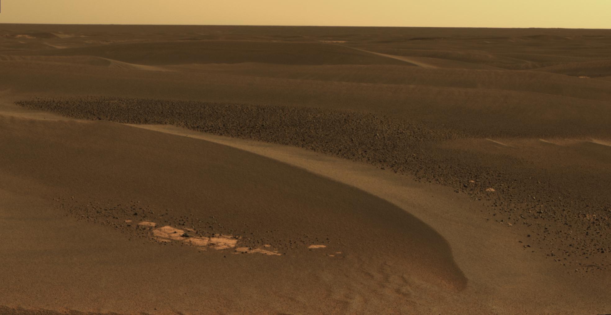 May 19, 2006 | Credit: NASA/JPL-Caltech/Cornell | Link >>
 August 29, 2014 | Credit: NASA/JPL-Caltech | Link >>
More:
mars.nasa.gov/resources/5849/endurance-craters-dazzling-dunes (2004)
mars.nasa.gov/resources/5878/opportunity-looks-back-after-hop-to-a-new-pad (2010)
science.sciencemag.org/content/353/6294/55 (2016)
agupubs.onlinelibrary.wiley.com/doi/full/10 (2018)
ruhrpod.org/martianripples (2021)