Introduction to Thessaloniki Geology with the added bonus of a great city view
Thessaloniki lies on the northern fringe of the Thermaic Gulf on its eastern coast and is bound by Mount Chortiatis on its southeast. Its proximity to imposing mountain ranges,hills and fault lines, especially towards its southeast have historically made the city prone to geological changes.
Not only has Theassaloniki an interesting topography, starting from sea level and reaching an altitude of 100 to 150m with smooth ascents, the geological setting of the city can be divided into two major parts: The crystalline bedrock, which outcrops at the N-NE part of the city reaching at a depth of 150 to 300m near the coastline in a W-SW direction and the soil formations that overly the crystalline rocks and cover the biggest part of the city: alluvial sediments of the Neogene period (23.03 million years ago - 2.58 million years) and Holocene period (11650 ad - today)
The coastal parts of Thessaloniki are built on Holocene alluvial deposits in a 2500 year old delta extending to the west of the city and occupying an area of about 2000Km² in Central Macedonia.
Interesting fact: During the era of Alexander the Great (≈ 500 B.C.), the city of Pella was located by the sea, but in time, the increasing river sediment discharge and the continental uplift caused the gradual regression of the sea and the relocation of the coastline by approx. 50km in SE direction. Therefore today Pella is no longer near the ocean.
Also, today, near Kalohori, geologists observe a subsidence phenomenon with land lowering by several cm each year. The phenomenon was first noticed in 1965 in form of a progressive sea water invasion.
Since then, several dams have been built, failed and have been rebuilt in order to stop marine waters to invade the land and threaten the city of Kalohori.
All through the delta and the city of Theassaloniki these geologically recent alluvial deposits consist of loosely compacted red clays, sand and pebbles.
The older parts of Thessaloniki however are built on the foothills of the Mount Chortiatis mountain range - as you noticed as you went to ground zero. Soil in this area are either comprised of gneiss, epigneiss and green schists from the crystalline bedrock or of red silty-clays of sedimentary origine.
At ground zero you will see evidence of one type of those rocks. Please read the definitions and decide which kind of rock you are looking at and why.
Gneiss:
Gneiss is a high grade metamorphic rock, meaning that it has been subjected to higher temperatures and pressures than schist. It is formed by the metamorphosis of granite, or sedimentary rock. Gneiss displays distinct foliation, representing alternating layers composed of different minerals. However, unlike slate and schist, gneiss does not preferentially break along planes of foliation because less than 50% of the minerals formed during the metamorphism are aligned in thin layers.
Texture - foliated, foliation on a scale of cm or more.
Grain size -medium to coarse grained; can see crystals with the naked eye.
Hardness - hard.
Colour - variable - generally alternating lighter and darker sub-parallel discontinuous bands.
Other features - generally rough to touch.

Schist
Schist is medium grade metamorphic rock, formed by the metamorphosis of mudstone / shale, or some types of igneous rock. Due to the more extreme formation conditions, schist often shows complex folding patterns. There are many varieties of schist and they are named for the dominant mineral comprising the rock, e.g. mica schist, green schist (green because of high chlorite content), garnet schist etc.
Texture - foliated, foliation on mm to cm scale.
Grain size - fine to medium grained; can often see crystals with the naked eye.
Hardness - generally hard.
Other features - generally smoothish to touch.

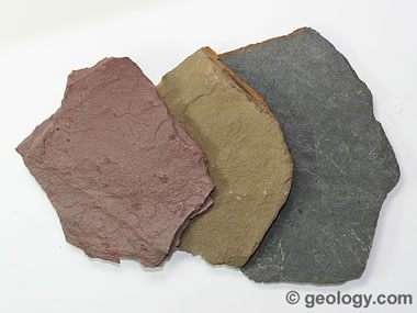
Shale
Shale is a fine-grained sedimentary rock that forms from the compaction of silt and clay-size mineral particles. It is fissile and laminated. "Laminated" means that the rock is made up of many thin layers. "Fissile" means that the rock readily splits into thin pieces along the laminations.
Texture - smooth
Grain size - fine-grained with tiny fragments of other minerals
Hardness - soft to medium
Other features - breaks along thin laminae or parallel layering or bedding less than one centimeter in thickness
In order to log the cache, send me your answer:
- Which type of rock do you see at ground zero according to the information above?
- Describe in your own words the rock composition and what it looks like
- How high is the visible formation at this location? (approximately)
- A picture nearby would be appreciated but is optional per Geocaching guidelines
You can log without my permission, but logs with no email to owner and / or reveiling pictures will be deleted.
sources: https://www.researchgate.net/publication/235760387_Thessaloniki's_Detailed_Microzoning_Subsurface_Structure_as_Basis_for_Site_Response_Analysis
https://www.researchgate.net/figure/Geology-of-the-Thessaloniki-Plain-and-location-of-the-coastline-according-to_fig1_280025473 https://flexiblelearning.auckland.ac.nz/rocks_minerals/rocks/gneiss.html
https://geology.com/rocks/