Welcome to Wyperfeld National Park.
Located in the flat, semi-arid north-western corner of Victoria, Wyperfeld is one of Australia's most fascinating national parks.
The central feature of this huge park is a chain of lake beds connected by Outlet Creek, the northern extension of the Wimmera River. The lakes only fill when the Wimmera River over-supplies Lake Hindmarsh to the south of Lake Albacutya. When it rains the semi-arid landscape is transformed by tiny desert plants that sprout from long-dormant seeds, carpeting the ground with clusters of flowers.
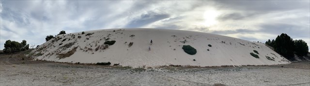
Mt. Jenkins is the focus today; we decided Mt. Jenkins was a little more out of the way than Snowdrift ( more popular Dune in the area) and is more suited to todays Earth Science Lesson.
Mt Jenkins is located on the Murray Basin plains, these plains contain an outstanding array of semiarid and riverine landforms of relatively young geological origin. These are of considerable conservation and scientific significance, and contribute to the distinctiveness of the Mallee. The landscape is one of low relief, gently sloping towards the Murray River to the north. However, this low relief belies the landform diversity that exists and its influence on the biota. Most of the area has a mantle of sands of marine origin and alluvium over an older land surface, but with occasional outcrops of the latter as lateritised sediments.
The sands were sculpted into dunes by wind action during the Quaternary period. The landforms of the area belong to two main geomorphic types: · the Mallee Dunefields, which covers most of the Big Desert (Wyperfeld) and the Sunset Country (Murray-Sunset and part of Hattah-Kulkyne), and is taken to include the complex groundwater discharge areas such as the Raak Plains and Pink Lakes; · the Riverine Plain, which occurs along the Murray River at Lindsay Island (MurraySunset) and Hattah Lakes (HattahKulkyne), and along the Outlet Creek system (Wyperfeld and Lake Albacutya).
The landforms are predominantly the result of three main factors: · the inundation of the area by the sea, most recently about 4 million years ago, which on retreat deposited a large sheet of sand (Parilla Sand), forming a stage for subsequent landforms and providing sand for some of the later dune formations; · past climates which were considerably drier or wetter than today, leaving a legacy of landforms such as lunettes and dunes of different types; · the presence of a shallow saline groundwater table existing in a delicate hydrological balance, which has responded to different climates to produce a range of landforms.
Dunefields are the most extensive geological feature and are found in Wyperfeld and surrounding areas, Mt. Jenkins is obviously a part of this system.
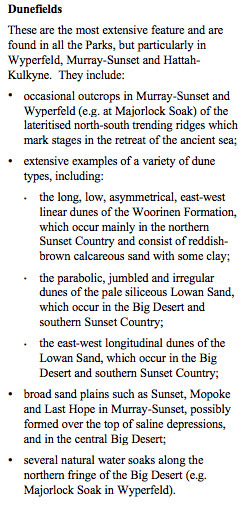
Parks Victoria have described the Dunes that can be seen in the Mallee area:
To log this Earthcache we require you to explore the immediate area, then, to the best of your ability message us with the following answers;
1. What type of Dune is Mt. Jenkins?
2. What type of sand is Mt. Jenkins made up of?
3. Is Mt. Jenkins moving? To answer this correctly you will need to move away from the main face to either end where there isn’t much human disturbance and watch the sand in front of you, does it move? Why is what you see happening?
4. A photo of your Team, GPS near GZ with your log and answers. (optional)
You are welcome to log your answers straight away to keep your TB's and Stats in order but please message us with your answers within a couple of days. Cachers who do not fulfil the Earth Cache requirement will have their logs deleted.
Acknowledgments: parkweb.vic.gov.au.