
Iron cycling is common in Earth surface systems. This cycling is often evidenced by the iron oxide minerals left behind in abundant concretions (cemented mineral masses) that can preserve the record of multiple generations of precipitation events and water–rock interactions. https://doi.org/10.2110/pec.12.102.0253 The widespread occurrence of terrestrial concretions in a variety of mineralogies indicates that concretion formation is a common geologic process in the near surface, porous sediments, and sedimentary rocks. Concretions (inclusively) occur in a wealth of sizes and mineralogies. Concretions are composed of a localized mass of cement (e.g., ferric oxide) that precipitates in pore spaces during diagenesis(Diagenesis - refers to the physical and chemical changes occurring during the conversion of sediment to sedimentary rock)in sedimentary rocks. Concretions are known to form in host rocks with diverse compositions; cements can include carbonates, iron oxides, sulfides, and silicates (Mozley 1989, Sellés-Martinez 1996, Seilacher 2001, Mozley and Davis 2005). Ferric oxide concretions form during early diagenesis (e.g., acid saline lake sediments; Benison and Bowen 2006, Bowen et al. 2008) or during burial diagenesis (e.g., Navajo Sandstone concretions; Chan et al. 2000, 2004, 2007; Beitler et al. 2005; Potter and Chan 2011) - See Chan et al., 2012.

Os óxidos de ferro (e os hidróxidos de óxido) são de grande difusão na natureza, desempenham um papel importante em muitos processos geológicos e biológicos e são amplamente utilizados por seres humanos, por exemplo, como minérios de ferro, pigmentos, catalisadores, etc. A ferrugem comum é uma forma de óxido de ferro (III). Os óxidos de ferro são amplamente utilizados como pigmentos baratos e duráveis em tintas, revestimentos e concretos coloridos.
Óxido de ferro (III) ou óxido férrico, também conhecido como hematite na sua forma mineral, óxido de ferro vermelho, ou simplesmente ferrugem, é o composto químico de fórmula Fe2O3. Possui propriedades paramagnéticas. O óxido férrico pode também ser obtido pela reação de óxido-redução: 4Fe + 3O2 → 2Fe2O3.
No registo geológico aparecem em inúmeros locais. Neste local ocorrem nos arenitos.
Como validar o registo desta EarthCache:
Passo nº 1 - De longe é preciso distinguir os arenitos* dos calcários.(*Arenito ou grés é uma rocha sedimentar que resulta da compactação e litificação de um material granular da dimensão das areias. O arenito é composto normalmente por quartzo, mas pode ter quantidades apreciáveis de feldspatos, micas e/ou impurezas. É a presença e tipo de impurezas que determina a coloração dos arenitos; por exemplo, grandes quantidades de óxidos de ferro, fazem esta rocha vermelha). Fonte - Wikipedia.
Esta é uma tarefa muito fácil e para vos ajudar, só precisam de olhar para a imagem infra:
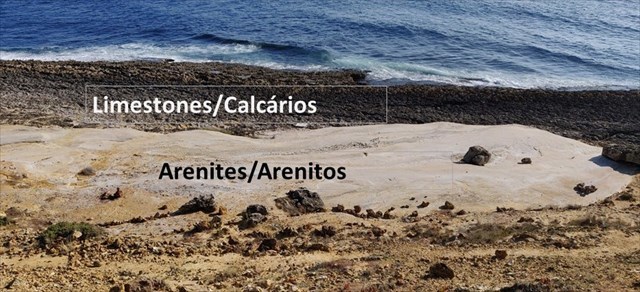
Como podes observar, os arenitos são as rochas mais claras, quase brancas, enquanto que os calcários, são muito mais escuros e estão mais perto da água.
Passo nº 2 - Dirige-te às coordenadas desta cache. Aqui precisas de estar com os pés em cima dos calcários, ou seja, no "X" da imagem e de costas para o mar. Observa atentamente os arenitos.
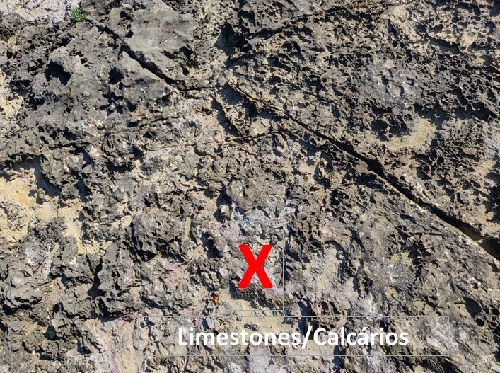
Nota: Os calcários são muito irregulares e cortantes. Não faças esta cache sem teres calçado adequado.
As tarefas para validar o "FOUND IT":
A. Concentra-te na "baía" de forma dos arenitos à tua frente. Nota umas linhas de óxidos de ferro escuras que atravessam estes arenitos. Responde às seguintes perguntas:
- Quantas camadas de óxidos de ferro podes observar do lado direito do afloramento?
- Quantas camadas de óxidos de ferro podes observar do lado esquerdo do afloramento?
- Quantas camadas de óxidos de ferro podes observar no centro do afloramento?
B. Observa as camadas do arenitos em si. Diz-me:
- As camadas são horizontais?
- As camadas são verticais?
- As camadas estão inclinadas?
(Caso nenhuma das hipóteses acima descritas corresponda a uma descrição fidedigna, descreve as camadas do arenito)
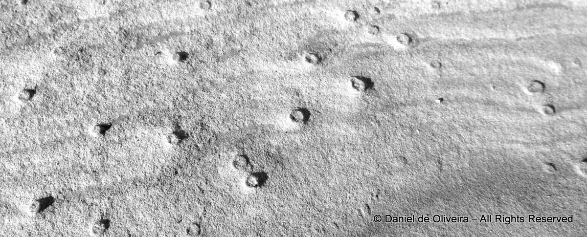
C. Tira uma fotografia do teu nick de geocaching esrito num papel/na mão/no braço ou onde quiseres junto aos nódulos que ocorrem na pate inferior do afloramento do teu lado direito (Isto é OBRIGATÒRIO!). Logo abaixo tens uma foto dos nódulos para te ajudar a identificá-los. NÃo coloques imagens spoiler ou apago o log. Log sem esta imagem=log apagado!
E é muito fácil! Envia-me as respostas através do meu PERFIL e claro que estás à vontade de acrescentar ao log todas as imagens da fantástica paisagem desde que não dê a resposta a nenhuma das tarefas.
How to validate and log this EarthCache:
Step 1 - You need to distinguish (from far) the arenites* from the limestones.{* Arenite (Latin Arena, sand) is a sedimentary clastic rock with sand grain size between 0.0625 mm and 2 mm and contain less than 15% matrix - Source: Wikipedia)}
This is easy and all you have to do is see the picture below:
As you can see, the arenites are the whitish rocks while the limestones are the dark coloured rocks closer to the sea.
Step 2 - Now you need to get to the GZ coordinates and and you need to stand on "X" (see picture below) with your back to the sea. Observe the arenites.
Note: The limestones are highly irregular and cut like sharp knives. You must have shoes on your feet.
The tasks to validate the "FOUND IT":
A. Concentrate on the arcuate, embayed form of the arenite. In this area, note the concentrations of iron-oxides present in the rocks. These are dark-brown lines. Answer the following questions:
- How many layers of iron oxides can you see on your right-hand side?
- How many layers of iron oxides can you see on your left-hand side?
- How many layers of iron oxides can you see straight ahead of you?
B. The layering of the arenitic rocks is clearly seen. Observe and tell me:
- Is the layering horizontal?
- Is the layering vertical?
- Is the layering at an angle?
(Should none of the above provide an accurate description of the layering according to you, please describe the layering)
C. Take a picture of your geocaching nickname writen on a piece of paper/hand/arm or whatever against the nodules that appear on the bottom right-hand side of the outcrop (This is not an option!). Below is a picture of these nodules to help you. NO spoiler images or the log will be deleted. NO picture=no log.
And it's that easy! Send the answers to me via my PROFILE and feel free to upload any scenic shots of the area as long as they don't give away any of the answers. Enjoy Coxos!

 The most exciting way to learn about the Earth and its processes is to get into the outdoors and experience it first-hand. Visiting an Earthcache is a great outdoor activity the whole family can enjoy. An Earthcache is a special place that people can visit to learn about a unique geoscience feature or aspect of our Earth. Earthcaches include a set of educational notes and the details about where to find the location (latitude and longitude). Visitors to Earthcaches can see how our planet has been shaped by geological processes, how we manage the resources and how scientists gather evidence to learn about the Earth. To find out more click HERE.