NOTE: You need to be able to enter the free-of-charge Fossil House Visitor Centre in order to complete this EarthCache. Typically, the Fossil House Visitor Centre is open between 12 noon and 4pm on Saturdays and Sundays between April and October. However, please check the Fossil Grove website (www.fossilgroveglasgow.org) for exact opening times before visiting.
(2019 Opening Times: 20th April to 20th October)
INTRODUCTION
The Fossil Grove is a quiet, picturesque area of Victoria Park famous for containing a group of 325 million year old fossilised lycopod trees from the Carboniferous Period. The fossils are housed within a small but informative visitor centre which you will need to be able to enter in order to complete the logging tasks for this cache.
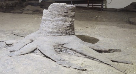
One of the fossil tree stumps inside the fossil house.
This EarthCache has been placed in collaboration with the Geological Society of Glasgow, the Strathclyde Geoconservation Group and the Fossil Grove Trust. For further information on the Fossil Grove, please visit: www.fossilgroveglasgow.org and for more general information see: www.geologyglasgow.org.uk/
HISTORY AND GEOLOGY
During the Carboniferous Period, 325 million years ago, Scotland was situated close to the equator and the area now occupied by the Fossil Grove was a swampy forest of lycopod trees. These trees were similar to modern clubmosses but they were much, much taller (often reaching heights of up to 45 metres, comparable to a modern 10-15 storey building) and had distinctive root systems that divide equally and symmetrically. In the grassy area just outside the Fossil House, an artistic sculpture loosely based on a lycopod tree gives you a chance to inspect their distinctive circular trunks and patterned bark up close. Inside, the trunks were not hard and woody but filled with a soft pith.
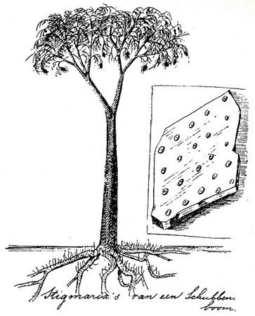
Artist's impression of a lycopod tree.
In close proximity to the lycopod trees of Fossil Grove, a major river system existed. This system was comparable in scale and form to the modern rivers draining the Himalayas, with several very wide but interconnected channels. When one of these nearby river channels burst its banks, the area was inundated by a series of fast flowing floods, probably similar in scale to those that affected the city of New Orleans following Hurricane Katrina in 2005. These floods killed the lycopod trees and deposited sediments around them that played an essential role in their fossilisation.
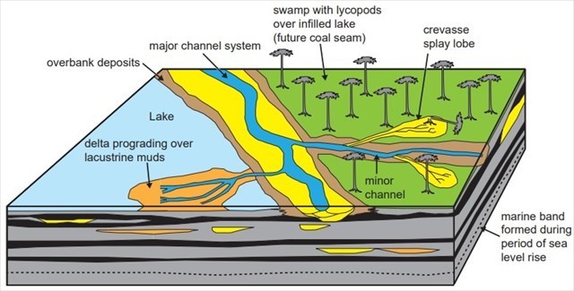
Schematic model of the depositional systems prevalent in the Fossil Grove area 320 million years ago. A minor channel has been breached during a flood and has deposited a sand-bed over the swamp, knocking down trees in the process. This is how the Fossil Grove formed.
The death and fossilisation of the lycopod trees found at Fossil Grove occurred in 6 main stages:
- The living trees were killed when the area in which they were growing was flooded and their roots and lower trunks were buried in sand and mud.
- The upper trunks, projecting above the sediment, broke off and were washed away.
- The soft pith inside the trunks decayed away leaving only the tough, outer bark.
- Another, fast flowing flood washed further sediment into the now hollow stump and roots.
- Over time, additional sedimentation events buried the stumps to depths of around a kilometre. At these depths, most of the water was forced out of the sand and mud, converting it into a type of sedimentary rock known as sandstone. The bark, meanwhile, was turned into to a very thin layer of coal.
- After discovery, the sedimentary rock outside the stumps and the thin coal layer that surrounded them were removed. This left the sandstone casts of the inside of the trees visible today.
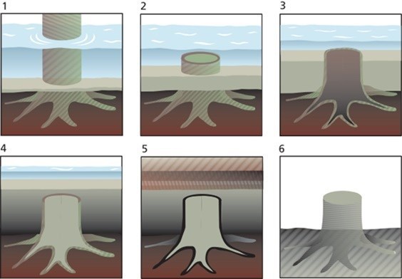
Schematic representation of the fossilisation process, highlighting the 6 main stages discussed above.
By the modern age, gradual erosion of the overlaying sandstone layers, coupled with extensive quarrying, had returned the fossilised trees to a location close to the surface. In 1887, a path was being cut through the area as part of the landscaping work for Victoria Park and this is how the first of the fossil tree stumps was uncovered. Further excavations revealed a total of 11 stumps though it is quite likely that additional (hitherto undiscovered) specimens exist in the surrounding rock.
In 1889, a decision was taken to leave the fossilised trees in situ, rather than remove them to a museum, and the Fossil House was built around them as a means of offering protection. This building is the world’s oldest surviving building designed specifically for geoconservation and it is owned and maintained by the Land and Environmental Services Department of Glasgow City Council with support from the Fossil Grove Trust. The contents of the Fossil House are designated a Site of Special Scientific Interest.
SITE MAP
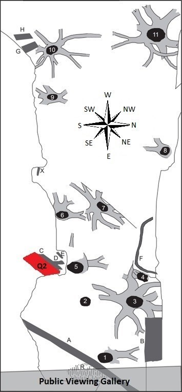
Map of the floor of the Fossil House
The map shows the locations of the fossilised stumps (1-11) as well as some tree fragments (A-H). The small fragment at (X) has some leaf scars. Following bomb damage Stump 9 has a concrete spacer inserted.
QUESTION 1
One of the fast-moving flood events that helped to form the fossils also deformed them so that they no longer have the characteristic round shape of living lycopod trees. What shape do the fossilised tree stumps have now?
QUESTION 2
Look at the area of rock highlighted in red and marked “Q2” in the site map. Describe its surface texture in as much detail as possible.
QUESTION 3
Some of the fossilised tree stumps show a distinctive scale-like imprint. By considering what you have learnt about the fossilisation process, suggest whether this imprint is of the inside or outside of the bark.
QUESTION 4
By referring to the site map and your observations so far, suggest which of the following compass directions the flood events that helped fossilise the trees were travelling in.
a) Towards the south-west
b) Towards the north
c) Towards the east
d) Towards the north-west
QUESTION 5
Explain your reasoning for your answer to Question 4.
LOGGING THE CACHE
When you log this EarthCache, feel free to include a photograph of your favourite tree stump (with or without yourself in it) and message the cache owner, either through email or via the Message Centre, with your answers to the five questions above. If there are any issues with your answers, I will contact you to discuss them. However, logs for which accompanying answers are not received at all (within 2 weeks of logging) will be deleted.
I hope you enjoy your visit to this EarthCache.