[AB01] Anse de Bréhec - Discordance EarthCache
[AB01] Anse de Bréhec - Discordance
-
Difficulty:
-

-
Terrain:
-
Size:  (other)
Please note Use of geocaching.com services is subject to the terms and conditions
in our disclaimer.
 L'anse de Bréhec à mi-chemin entre Paimpol et St Quay Portrieux est un site géologique très intéressant. Les formations qui affleurent sur ce tronçon de la côte appartiennent aux séries rouges du domaine nord-armoricain et reposent en discordance sur le socle briovérien local.
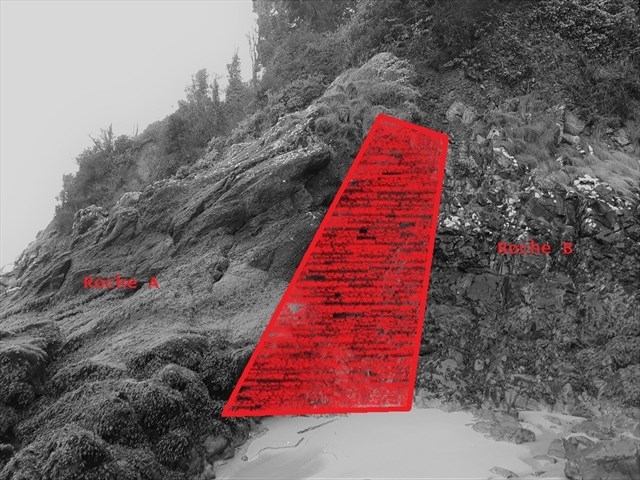
Ce premier arrêt permet de montrer la discordance entre la base de la série rouge de l’Ordovicien et les grès du Briovérien. Elle est repérable au Sud de la plage sur l’estran et dans la falaise. Cette discordance est recoupée par des failles normales.
 The cove of Bréhec halfway between Paimpol and St Quay Portrieux is a very interesting geological site. The formations that outcrop on this stretch of the coast belong to the red series of the North Armorican domain and lie unconformably on the local Brieurian basement.
This first stop shows the discrepancy between the base of the Ordovician red series and the Brioverian sandstones. It is located south of the beach on the foreshore and in the cliff. This discrepancy is intersected by normal faults.
Rappel géologique / Geological reminder
Discordance (discordere = être en désaccord)
Repos d’une strate sur des couches géologiques plus anciennes qui ont pu être plissées ou basculées antérieurement par des mouvements tectoniques (orogenèse) et qui sont parfois en partie érodées. Une discordance régionale exige une succession de phénomènes :
1- période de sédimentation (transgression)
2- phase tectonique avec plissement pouvant être accompagné de phénomènes magmatiques et/ou métamorphiques
3- émersion (régression) et érosion => élaboration d’une surface d’érosion
4- période de sédimentation marine (transgression) ou continentale ; la surface d’érosion devient surface de discordance.
Sur une carte géologique, on détermine qu’une formation est discordante par rapport aux autres quand sa limite de base interrompt les contours de plusieurs formations plus anciennes.
Grès
Roche sédimentaire détritique formée de plus de 85 % de grains de quartz, de taille comprise entre 1/16 mm et 2 mm. Ils sont assemblés par un ciment siliceux et/ou calcaire. En raison de l’altération très lente des quartz, les grès sont parmi les roches sédimentaires les plus communes.
Conglomérat
Roche sédimentaire détritique formée par l’accumulation de débris rocheux dont au moins la moitié ont une taille supérieure à 2 mm. Ces éléments sont liés par un ciment. On parle de brèche quand les éléments sont anguleux et de poudingue quand ils sont arrondis.
Discordance
Rest of a stratum on older geological layers that may have been folded or tipped earlier by tectonic movements (orogenesis) and which are sometimes partly eroded. Regional discrepancy requires a succession of phenomena:
1- sedimentation period (transgression)
2- tectonic phase with folding that may be accompanied by magmatic and / or metamorphic phenomena
3- emersion (regression) and erosion => elaboration of an erosion surface
4- marine (transgression) or continental sedimentation period; the surface of erosion becomes surface of discordance.
On a geological map, it is determined that one formation is discordant with respect to the others when its base limit interrupts the contours of several older formations.
Sandstone
Detritic sedimentary rock formed from more than 85% of quartz grains, between 1/16 mm and 2 mm in size. They are assembled by a siliceous cement and / or limestone. Because of the very slow weathering of quartz, sandstones are among the most common sedimentary rocks.
Conglomerate
Detritic sedimentary rock formed by the accumulation of rock debris of which at least half are greater than 2 mm in size. These elements are linked by a cement. We speak of breach when the elements are angular and pudding when they are rounded.
!!! ATTENTION CACHE UNIQUEMENT ACCESSIBLE A MAREE BASSE !!!
!!! WARNING EARTHCACHE ONLY ACCESSIBLE LOW TIDE !!!
Avant de vous y aventurer, consulter l'horaire des marées :
Before you go, check the tide schedule:
Horaires des marées
Questions pour valider cette earthcache :
D'après vos observations et à l'aide du descriptif,
Questions to validate this earthcache:
Based on your observations and using the description,
Question 0
Joindre à votre log une photo de vous, votre GPS, votre GC perso ou tout autre objet vous représentant dans le jeu aux coordonnées du listing (SANS MONTRER LES REPONSES !).
Attach to your log a photo of you, your GPS, your personal GC or any other object representing you in the game at the listed coordinates (WITHOUT SHOWING THE ANSWERS !).
Question 1
La discordance est-elle totalement droite ou en escalier ?
Is the discordance totally straight or stepped ?
Question 2
Décrivez (couleur, texture, composition, ...) et identifiez les roches A et B de part et d'autre de la discordance.
Describe (colour, texture, composition, ...) and identify rocks A and B on both sides of the discordance.
Envoyez-moi vos propositions de réponses soit via mon profil, soit via la messagerie geocaching.com (Message Center) PUIS loguez cette cache "Found it", je vous contacterai en cas de problème.
Assurez vous de répondre à TOUTES les questions ! La condition principale pour loguer une Earthcache étant de répondre aux questions posées dans le descriptif, tout log "Found it" enregistré sans envoi préalable de vos propositions de réponses sera supprimé.
De même, tout log enregistré sans la photo requise attachée sera supprimé.
Send me your proposals for answers either via my profile or via the geocaching.com messaging (Message Center) THEN log this cache "Found it", I will contact you in case of problem.
Make sure to answer ALL questions ! The main condition to log an Earthcache is to answer the questions asked in the description, any log "Found it" registered without prior submission of your proposals of answers will be deleted.
Likewise any log save without the required photo attached will be deleted.
Additional Hints
(Decrypt)
A'bhoyvrm cnf ibger cubgb fbhirave (FNAF ZBAGERE YRF ERCBAFRF !)
Qba'g sbetrg lbhe fbhirave cubgb (JVGUBHG FUBJVAT GUR NAFJREF !)