Are you ready for a dip in Neabsco Creek? Do you have your swimsuit, noseplug, goggles and rubber ducky? Good! Now put all that stuff back away, because we are doing a completely different kind of Dip in Neabsco Creek. ,
Along the shores of Neabsco Creek are sedimentary rocks that are often tilted until they are almost vertical. These rocks didn't form this way! Sedimentary rocks are layed down in layers and those form horizontally. In the illustration below, the ocean basin (brown hatched) contains layers of sandstone (yellow dotted), shale (bluish brown dashed) and limestone (pink bricks) [these are the standard symbols for these units used on all geologic cross sections]. Each layer is layed down horizontally. These units are often called "beds". Learn more here

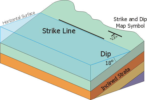
In parts of the midwest, sedimentary rocks are found in horizontal or nearly horizontal units. But here in Virginia and throughout the Appalaichan Mountains, rocks seldom occur in horizontal layers. In some places, they nearly stand on end. This is because of ancient mountain building that compressed and deformed the rock units. In an area like this, among the most useful tools for the geologist are strike and dip. "Strike" is the horizontal line where a tilted unit intersects an imaginary horizontal surface. In the image below, the blue represents water and where the imaginary shoreline intersects the rock, that line is the strike. Strike is usually expressed as degrees East or West of North. So, a strike that is 45º West of North is what you might think of as NW. The dip is perpedicular to the strike and always downslope. In this case, the dip angle is the angle between the top and bottom of the imaginary blue wedge. Strike and Dip are shown on maps with an exaggerated T where the crossbar of the T represents strike and is placed on the map in the correct orientation and Dip is shown by the downstroke of the T with the dip angle listed in degrees. Learn more here

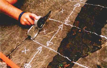
For more than a century, geologists have used a Brunton compass to measure strike and dip. Patented in 1894, this device measures strike by determining the orientation relative to North of the horizontal line. Dip is measured perpedicular to the strike. After placing the Brunton compass against the rock with the compass on edge, a device called "clinometer level" is placed to center a bubble in a fluid, just like a level you have at home. The dip can be read from the scale once leveled. As you can see, a key to this process is that you need a large surface to place the entire compass on the rock face. Think of it like a deck of cards - you need to place the entire compass on the face of a card, not across the end of the deck of cards! Learn more here

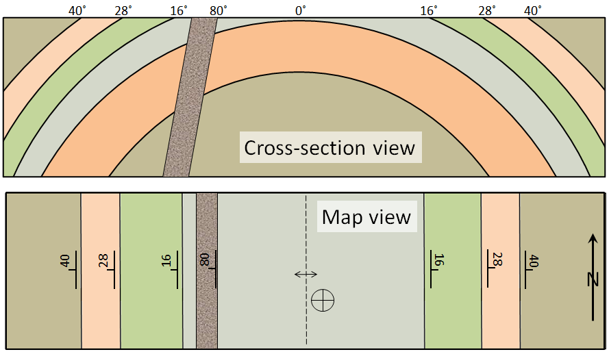
Strike and Dip are essential tools for geologists in understanding the orientation of rocks units, the nature of large scale structures, and the processes by which they formed. Sometimes geologists get lucky and are able to see rocks in cross section. Sideling Hill in Western Maryland is a great example where compression pushed the center of rock layers downward, creating a U-shaped structure geologists call a syncline. Unfortunately, we seldom get to see cross sections. Think about it - a river may just cut through geologic layers (e.g., the Grand Canyon), but you would never dig a roadcut through a hill without knowing into what you are digging! No, geologists have to determine the structure by measuring the strike and dip. In the example below, the bottom panel shows that the dips of the sedimentary units (blue, green, pink and gray) are all pointing away from the center of the feature and the dips increase as you get further from the center. This tells geologists that we are looking at a structure where the center of the units is lifted upwards - an anticline.

Believe it or not, we can even measure strikes and dips of rock units on Mars. I worked on the Mars Exploration Rover Spirit in the Columbia Hills of Mars for 5 years, in part working on the structure of the Columbia Hills. How did we meausre strike and dip? We certainly didn't take a brunton compass with us! In fact, it wouldn't have worked because Mars doesn't have a global magnetic field that makes a compass work. Instead, we reconstructed the exact position of each rock until based on images taken by the rover in different positions. It was time consuming, but it worked. Although not nearly as neat as the example above, we found that units to the NW tended to dip NW, whereas units to the SE tended to dip to the SE. We had an anticline on Mars! You can read the original scientific paper here

Okay, you believe me and understand how important strike and dip can be to a geologist. What's the problem? The problem is that sometimes you find dipping geologic rocks, but they are so small or the surfaces of the individual units lack flat exposed surface so that you can't actually measure the strike and dip easily. The rock below is a great example of this type of small outcrop. Only a few feet across, you see the ends of the layers of rock - like the end of the deck of cards - with almost none of the bedding - the face of the cards - exposed. You can't measure the dip on this kind of rock outcrop, even though you can clearly see the rocks dipping away from you. Very frustrating!! What do you do? More often than not, you keep looking for a better example where you CAN measure the strike and dip. On Mars, we were only able to measure strike and dip confidently on 7 rock layers!!

Logging this Earthcache
With that as background, you only have to do 3 things for this Earthcache:
1) Go to the Waypoint on the way to GZ and describe what you see. Are there rocks exposed? How big are the outcrops of layered rock? A rough estimate is fine. Are you looking at the ends of the beds (the end of the deck of cards) or the face of the beds (like the face of a card)? Could you measure strike and dip on these units?
2) At GZ, you will be standing on the opposite bank of Neabsco Creek from a geological unit. Describe what you see in your own words. Is the exposed rock unit bigger or smaller than at Waypoint 1? Can you see the ends of the bedding units? How about the face of the bedding unit? Feel free to send a photo, but it isn't required.
3) Estimate the dip of this unit. Is it straight up and down (90 degrees) or horizontal (0 degrees) or somewhere in between?
Send your answers to the CO. After sending your answers, go ahead and log. I'll contact you if there is a problem. Any Found log not accompanied by the answers within a reasonable amount of time will be deleted without notice. NO night caching and please be respectful of the neighbors; DO NOT cut across someone's yard just to get this cache. PLEASE do not post photos or descriptions of the unit at GZ, although there are numerous other scenic geologic formations along Neabsco Creek and you are encouraged to post photos of these. Finally, enjoy this beautiful example of geology.
