Blackchurch Rock is the result of stunning sedimentary rock formations, spectacular wave erosion and also rock folding created during plate movements long ago. This EarthCache looks at the sedimentary rock formations and the wave erosion, whilst the sister EarthCache a few miles up the coast at Hartland Quay looks at the rock folding and different aspects of the sedimentary rock.
Please note, like the sister EarthCache at Hartland Quay, to complete this EarthCache you will need to consider the tide times as it is not accessible at high tide. The feature you need to visit is close to the cliffs so can be visited most of the time, but it will be inaccessible at high tide and is best visited on a falling tide.
Blackchurch rock includes exposures of the Hartland Quay Shale that contains goniatite fossils. Goniatites are also found at two sites where there are exposures of Gull Shale Rock - two anticline structures (folds with the fold axis at the top) 300m and 400m southeast of Blackchurch Rock. It is the types of goniatite found in the ‘marker horizons’ of these features that have helped to date the rocks. Keep an eye out, you might be lucky enough to spot one.
Sedimentary rocks will be found here...
It should be fairly obvious when you arrive here to see the rock is in very well defined layers and this means they are sedimentary. Sedimentary rocks can be formed from particles of sand, shells, pebbles, and other fragments of material. Together, all these particles are called sediment. Gradually, the sediment accumulates in layers and over a long period of time hardens into rock. An example might be millions of years ago a flood caused a layer of sand to be deposited. This might create one layer of the rock you see here. Then maybe a few years or many years later another flood left another layer of sand. Again, another layer is created. This process continued for millions of years, the lower layers gradually getting squeezed more and more by the heavy deposits above them. The thickness of the layer is determined by the amount of sediment deposited, therefore a bigger and longer flood would deposit more sediment creating a thicker layer.
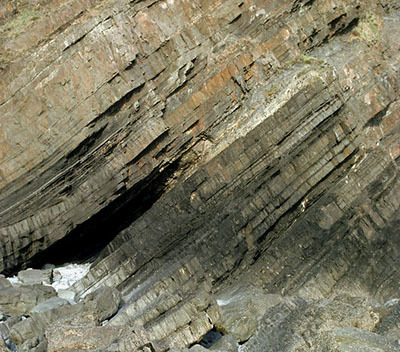
As you can probably imagine, if these rocks were formed by sediment left by water, the rocks when formed would have been flat - or horizontal on the ground. Any rocks you see at Mouthmill that are not flat or horizontal on the ground have been moved later by geological processes and the sister EarthCache at Hartland Quay looks at this in more detail. But even without considering the angle the rocks are at, Blackchurch Rock is a superb example of a sedimentary rock formation and the layers are extremely clear to see in the best and most spectacular form.
The sedimentary rocks you see before you here were deposited in a shallow sea during the Carboniferous period – about 320 million years ago. The layers are sequences of shales and mudstones representing the remains of sub-marine “avalanches” of sediments called turbidites. At the same time as the sands and mudstones were being deposited at Hartland, coals were being deposited in swamps, forming the South Wales coalfields.
Sedimentary rock is not always consistent and because the rock here at Mouthmill Beach has been formed of shales and mudstones there is a variation in strength. As explained above, each layer is formed at a different time and from a different 'batch' of sediment. This means some layers may be strong whilst some are more weak and therefore more susceptible to erosion forces many years later.
Wave Erosion: Caves, Arches, Stacks and Stumps
Wave erosion is a specific type of erosion caused by the power of tides and waves projecting sea water and sediment within the water, at the cliffs and rocks found on the shore. Although the sea contains chemicals and salts, it is not believed that chemical erosion plays any real part in creating the type of feature you see here today. There are two main processes responsible, and these are:
- Hydraulic Action: where the motion of water against a rock surface produces mechanical weathering. Most generally, it is the ability of moving water (flowing or in this case waves) to dislodge and transport rock particles.
- Abrasion: the occurance of mechanical scraping of a rock surface by friction between rocks and moving particles during their transport by wind, glacier, gravity, running water or in this case, waves. Rocks and sediment are found within the sea and the power of the waves brings them into contact with the rock on the shore.
Caves, arches, stacks and stumps are erosional features that are commonly found on a headland. Although all these features may seem to be different they are all simply different points of a particular erosional process.
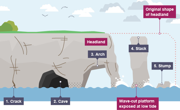
- Cracks: once a crack occurs, it will become widened in the headland through the erosional processes of hydraulic action and abrasion as explained above.
- Caves: over a period of time, the waves continue to grind away at the crack, and it slowly opens up getting bigger and it may then form a cave. A cave is simply a hole in the rock and is usually defined as such when it becomes big enough for a human to enter.
- Arch: again, over a period of time the cave becomes larger and eventually breaks through the headland to form an arch.
- Stack: as the sea continues to erode the rock the base of the arch continually becomes wider, until its roof becomes too heavy and collapses into the sea. This leaves a stack (an isolated column of rock).
- Stump: the final part of the process sees the the stack becoming undercut at the base until it collapses to form a stump.
Logging Requirements: Questions to Answer
The given coordinates bring you to the spectacular Blackchurch Rock. Although this type of feature is not uncommon, the sedimentary rock here and the angle it is at makes this an unusual and spectacular example of the erosional processes. For more information on why the rock here is at this angle please visit the sister EarthCache at Hartland Quay. For the purpose of this EarthCache we are interested in the sedimentary rocks that form the feature here and the way they have been eroded in the spectacular form you see today. The questions all relate directly to the information provided in the listing so you should be able to answer everything from GZ with no extra reading required. Please ensure you send in the answers at the time or soon after you log your find as logs may be deleted if no attempt at the answers are made.
Q1 - Above we have looked at the erosional process of cracks through to stumps. At what stage of the erosion process is Blackchurch Rock currently at (e.g. do you see a crack/cave/arch/stack/stump)? Unusually, you will see a double feature here as there are two formed from the same rock.
Q2 - For both features, please measure the distance between the layers (e.g. the width of the gap) for both features and give me their sizes (you are not expected to bring a tape measure, just a good estimation). Which is wider - the one closer to the sea or the one closer to the shore and is that what you'd expect?
Q3 - Turn your attention to the sedimentary layers that make up Blackchurch Rock. Firstly look closely at the layers that are fully intact and least eroded. Describe the rock here. Include the size of the sediment making up the rock, the colours, hardness.
Q4 - Now turn your attention to the eroded layers where the holes have developed. Describe the rock here. Include the size of the sediment making up the rock, the colours, hardness. In particular, highlight any differences between the rock making up the layers here with the answers in the previous question.
Q5 - Based on your analysis of the rock layers in the previous two questions, now please draw your conclusion. Do you think the layers of rock that have been eroded were made from weaker material - or - do you think the layers throughout the rock are consistent and the layers that have eroded have simply been unlucky to have been the ones affected by the erosional processes of the sea?
Q6 - As time goes on the erosion of Blackchurch Rock will continue. What is the next thing you think will happen here? How long away do you think that might be?
Optionally, a photograph of you or your GPSr with the feature at the given coordinates would be good additional proof of your visit and certainly a great memento as this is a perfect place for photography - but please avoid making it too much of a spoiler.
Thank you for visiting Blackchurch Rock