This EarthCache will take you to two sites in Burwell which show how geology has played a major role in this Fen-edge village’s history by affecting both its local architecture and its industry – the building of local structures using material extracted from local quarries. The sites are within walking distance of each other but it is also possible to drive between them and park nearby on-street in each case.
There are 6 questions (A-F) to answer. The answers to some require observations at the waypoints, while others can be found in the earth lessons. Observations can be made at the waypoints given which are on public green-space or on the public highway. We will accept answers sent to us via email or through the Message Centre, but please do not include your answers in your log. DO NOT enter any private property.
Earth Lesson: Geology
The geological layers beneath Burwell form quite a simple ‘layer cake’ of strata. While the land surface slopes gently down from the hilly ‘heath’ around Newmarket in the south east to the low-lying, flat Fenland in the north west, the strata generally slope downwards in the other direction. As a result the various layers appear at the surface as a series of roughly parallel ‘stripes’ of varying width.
This can be seen in this simplified map and cross-section (based on British Geological Survey information) which shows how a layer of Gault Clay underlies layers of Lower and Middle Chalk:
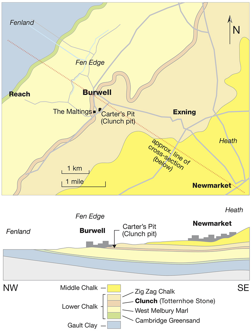
Chalk is a soft, white, porous, sedimentary carbonate rock, a form of limestone composed of the mineral calcite (calcite is an ionic salt called calcium carbonate or CaCO3) and it forms under reasonably deep marine conditions from the gradual accumulation of minute shells shed from micro-organisms.
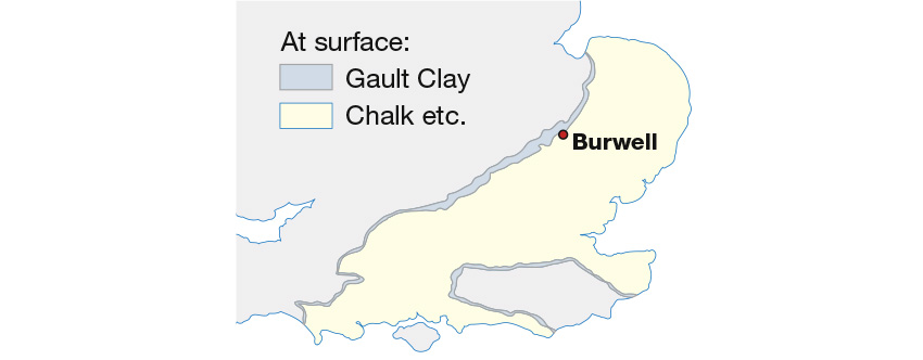
Gault clay is a stiff blue clay which was deposited in a calm, fairly deep-water marine environment during the Lower Cretaceous Period. This type of clay has been used in several locations for making bricks, including Burwell. The band of Gault Clay emerging from beneath the chalk can be traced in a line stretching right across England from the Dorset coast to the Wash (as well as on the North and South Downs) as shown in this map:
Earth Lesson: Weathering
Weathering is the breaking down of rocks, soil, and minerals (as well as artificial materials such as bricks), through contact with the Earth's atmosphere, water, and biological organisms. It is a process of change over time. Buildings made of any stone, brick or concrete are susceptible to the same weathering agents as any exposed rock surface.
Two important classifications of weathering processes exist – physical and chemical weathering; each sometimes involves a biological component. (i) Mechanical or physical weathering involves the breakdown of rocks and soils through direct contact with atmospheric conditions, such as heat, water, ice and pressure. (ii) Chemical weathering, involves the direct effect of atmospheric chemicals or biologically produced chemicals in the breakdown of rocks, soils and minerals.
The Stages
Stage 1: Carter’s Pit (Clunch quarry)– at the posted co-ordinates – Terrain 1.5
The modern Bloomsfield housing estate stands in what was originally a stone quarry (or ‘clunch pit’) where the hard chalk known as clunch was extracted. Clunch occurs as a layer within the ‘Lower Chalk’ and has softer chalk above (the Zig Zag Chalk) and below (the West Melbury Marl) - see the map/section.
In the absence of better local alternatives clunch was used extensively and over many centuries for building (see Stage 2).
The quarry was sited where a good, un-weathered and nearly-horizontal layer of clunch lay just below the surface. The diggings extended over the whole area now occupied by the estate and quarrying ended in 1952.
Part of the 'cliff' at the edge of the quarry workings can be accessed on a public green-space at the co-ordinates given.
QUESTIONS FOR CARTER'S PIT:
A: At the co-ordinates given, examine the rock face and describe the stone you see in terms of colour, texture and hardness.
B: All the rock faces show that the sedimentary chalk here can be seen in distinct layers. Identify the layer of clunch and describe how different it is from the layer below it. What geological process may have caused the difference?
C: At the co-ordinates given, estimate the height of the 'cliff' at the back of the quarry as this will give a good idea of just how deep the clunch was extracted from this quarry.
D: Using the earth lesson, including maps and sections on this page, what is the more formal geological name for clunch (T--------- S----)?
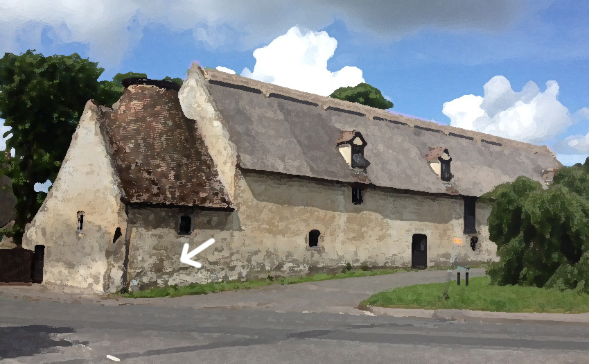
Stage 2: The Maltings – waypoint 02 – N52 16.092 E000 19.740 - Terrain 1
The Maltings is one of many characteristic, historical Burwell buildings built primarily of clunch. It was built in the 18th century, and has an integral malt kiln (the structure with the conical roof).
The building stands immediately adjacent to the public highway from which it can be examined easily. Do not touch the building or enter any private property.
Clunch is relatively easy to quarry and can be cut, shaped and incised easily. It has some limitations as a building material, however, as shown by the use of brick for window surrounds, wall bases and corners. Where they are left open to the elements, clunch blocks used in a building are often lime washed, and lime mortar (rather than cement) is used in the building process.
QUESTIONS FOR THE MALTINGS:
E: Compare the general condition of the clunch blocks higher up in the walls of the Maltings with those near the base. What do you notice, and what process of change over time does this show? How does this affect clunch's usefulness as a building material?
F: Over the years Burwell residents with time on their hands have left their personal marks in the clunch on The Maltings. Look at the graffiti on the east-facing wall, between the two hydrant markers, at the waypoint co-ordinates (alongside Mandeville [public road]). See if you can spot a face, two hands, a ladder and a house amongst others. What property of clunch has allowed all these to be made, and if you can find it, what is the large letter just to the right of the large letter 'A'? (this is directly below the window - see arrow on photo above):