[ES]
El Cerro Pantojo (o Cerro Pantoja) es un estratovolcán extinto. Se encuentra a pocos km al sur del Paso Fronterizo Cardenal Samoré justo en el límite entre la provincia del Neuquén, Argentina y la Región de Los Lagos, Chile. Su forma característica es un cuello volcánico erosionado.
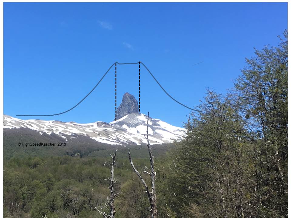
En el centro de un volcán se puede solidificar la lava. Se puede endurecer dentro de la chimenea del volcán, dentro de un filón o dentro de una colada de lava. Si eso occure se llama un cuello o tapón volcánico. Se compone de un conjunto de bloques angulares que se solidificó en la chimenea del volcán y que suelen ser más masivas que el cono mismo. Su estructura es resistente a la erosión, por lo que una vez que el cono se erosiona, este cuello permanece como una aguja relicta del cono desaparecido
Al contrario del Volcán Puntiagudo al sur del Volcán Osorno el Cerro Pantojo no producía erupciónes desde miles y miles de años. Cuantos hay que averiguar con las preguntas.
El cache os conduzca al mirador sobre la Ruta Nacional 231 donde se puede apreciar la vista hacia este volcán. Allá encontrareis un parking y algo interesante sobre el "pitón".
El Cerro Pantojo fue un estratovolcán andesitico de la época del pleistoceno tardío en la era cenozoico. Para registrar esta caché, por favor complete la tarea:
Preguntas
1.) ¿Durante qué período entraba en erupción? (actualisación 22.01.2023: termino que ahora no encontrareis al lugar mismo porque el tablero se a quitado una tormenta.)
2.) ¿Hace approximadamente cuantos años entraba en erupción\ (número en el tablero)
3.) ¿De qué color es la roca del Cerro y cuál es el nombre de esa roca?
4.) Una photo del Cerro en vuestro log con o sín un objeto personal que muestra el cambio durante las temporadas.
Envíenos un correo electrónico a través de nuestro perfil en esta página dando las respuestas a las preguntas 1-3. No los respondas en tu registro. Los registros sin respuestas de apoyo pueden ser eliminados. Por favor incluya su dirección de correo electrónico ya que hace más fácil para responder. No es necesario esperar a una respuesta antes que hacer el log. Nosotros enviaremos un mensaje si hay algún problema con las respuestas. No dude en enviar tantas fotos como desee, pero por favor no del orígen de las informaciones.
[EN]
The "Cerro Pantojo" (or "Cerro Pantoja") is an extinct stratovolcano. It is located some kilometres south to the Cardenal Antonio Samoré Pass ("Paso Internacional Cardenal Samoré") at the border between the provinces of "Neuquén", Argentina and of "La Región de Los Lagos", Chile. Its characteristic form is the one of an eroded neck.
In the centre of the volcano the lava may el harden. It may consolidate in the chimney, a seam or a stream of lava. If this happens it is named neck. It consists of angular (polygonal) blocks which consolidate in the chimney. These blocks usually are more solid than the cone of the volcano. Consequently its structure resists the erosion better than the cone. Once the cone has eroded the "neck" is the remaining leftover of the ancient volcano.
In contrast to the volcano Puntiagudo south to the volcano Osorno the Cerro Pantojo did not erupt since thousands of years. For how many years it has to be figured out in questions below.
The cache will guide you to the viewpoint at the "Ruta Nacional 231" where you will be able to enjoy the perfect view to this volcano. The you will find a huge display panel which informs you of the "hump" (as "pitón" in Spanish means "hump".
The "Cerro Pantojo" was a stratovolcano in the Andes of the late Pleistocene in the Cenozoic era. This leads to the questions which are ncessary to answer to claim the present earth cache:
Questions
1.) The "Cerro Pantojo" erupted during which geological period? (term you will temporarily not find on site because the huge panel is "gone with the wind")
2.) How many years ago the eruptions took place? (number)
3.) What is the color of the Cerro and what is the name of this rock type?
4.) Add a photo to your log showing the Cerro. With or without a personal item we don't care but we would like to see the Cerro at different seasons.
Please send us the answers to the 3 questions via e-mail on our profile page adding your username in the subject as this is easier for us. And please do not post the answer in your log. Logs without an e-mail we will delete. You won't need to wait for a log permision as we will contact you in case of doubt. You are very welcome to add photos of the location - but not from the origin on site. Enjoy and Happy caching.
Hay poca información electrónico pero vale la pena de hacer un vistazo acá:
Cerro Pantojo en Wikipedia
Lara, Luis; Rodríguez, Carolina; Moreno, Hugo; Pérez de Arce, Carlos (July 2001). "Geocronología K-Ar y geoquímica del volcanismo plioceno superior-pleistoceno de los Andes del sur (39-42°S)". Revista geológica de Chile (in Spanish). Santiago: SciELO. 28 (1). doi:10.4067/S0716-02082001000100004. ISSN 0716-0208. Retrieved 24 September 2015.
Cuello volcánico en Wikipedia