Welcome to the 2019 Edition of Cache Across Maryland, hosted by the Maryland Geocaching Society. This is one of ten geocaches placed throughout the "Old Line State" in locations chosen to showcase Maryland's diverse beauty, history and terrain. From the mountains of Western Maryland to the Atlantic Ocean, Cache Across Maryland 2019 will again demonstrate that Maryland truly is “America in Miniature”.
Each of the ten geocaches contains a code which you will use to determine the location of the CAM 2019 Picnic to be held on May 4th, 2019. The code can be found on the inside of the cache container and on the inside front cover of the logbook. Don't forget to record this code! Any geocacher who has completed all TEN of the CAM geocaches and attends the CAM Picnic on May 4th will receive a Certificate of Completion and a Cache Across Maryland 2019 commemorative geocoin in antique copper. We hope you enjoy CAM 2019!
Algonquin Cross-County Trail
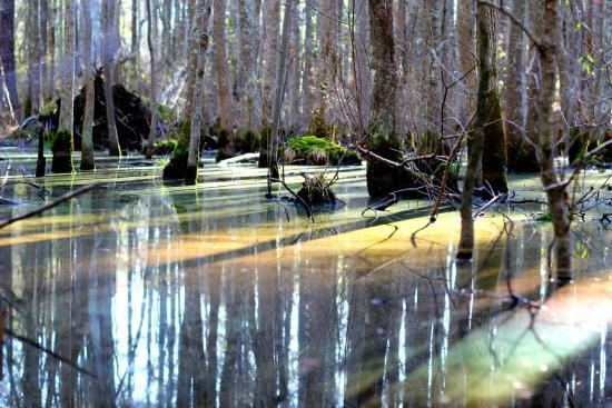
Pocomoke State Forest is characterized by large areas of loblolly pine, mixed-pine hardwood, bottomland hardwood and bald cypress forests. The Cypress swamps, which are State-designated wildlands, border the Pocomoke River, a State-designed Scenic River. There is a small, roughly 5-acre remnant of Old Growth forest among the 18,198 acres of land this State Forest encompasses.
Before the establishment of the State Forest, much of this land been cleared for farming or used as farm woodlots. Many farmers fell on hard times during the Great Depression, resulting in the acquisition of large tracts of land by the Federal Government. In the mid- to late-1930's, two Civilian Conservation Corp (CCC) camps were established within the Forest. The camp workers did considerable road and trail work, established boundary lines, provided for fire protection and suppression, planted trees, and provided recreational improvements at Milburn Landing. In 1954 the Federal Government deeded the land to the State.
A significant portion of Pocomoke State Forest has been managed for industrial forest production for decades, and was a major contributor to the region's forest products economy. Five pine sawmills and two pulpwood chipping operations provided an outlet for timber from the forests.
Today, the State Forest has over 25 miles of hiking trails available for day hikes or multi-day experiences. The Algonquin Cross-County Trail is 12.5 miles long, winding through the Chesapeake Forest and Pocomoke State Forest from Snow Hill - off MD Route 12 south of Salisbury - to Milburn Landing State Park along the Pocomoke River. This is the trail you'll be following to locate this cache.
Park amenities and activities include:
- Camping in Pocomoke River State Park (Milburn Landing & Shad Landing areas; by reservation)
- Canoeing
- Fishing
- Hiking
- Horseback riding
- Hunting - pay attention to hunting seasons, and wear orange
- See the Maryland Dept. of Natural Resources page for more details on these and other activities.
Forest Regulations:
- Hours: Open Daily, sunrise to sunset (closed to the public after dark)
- Keep all pets on leash; clean up after your pets.
- There are no restroom facilities in the State Forest - plan accordingly.
- No alcoholic beverages.
- Do not block any gates.
- No motorized off-road vehicles allowed in the Forests.
The Geocache
Park at one of the two designated parking areas.
P1 parking area is smaller, but the approach to the cache is drier. From here, follow the Algonquin Cross-County Trail/Old Furnace Orange Loop north to MM6 (the provided T1 coordinates), where you will find a well-used deer trail that will lead you to the cache.
P2 has the larger lot, and trailhead T2 is directly across the road to the north. This trail is often wet, so be prepared for wading.
Hold onto children due to mosquitos.
Cell service may be spotty - come prepared with a dedicated GPSr unit.
No bushwhacking is required to reach the cache.
The cache is located at the posted coordinates.
As with any outdoor activity, geocaching has potential risks. It is your responsibility to determine those risks and make your own choices in pursuing a geocache. If at any time you are injured or need emergency assistance, dial 911.