
Histoire
L'exploitation de l'ardoise dans la région de Mûr-de-Bretagne et Caurel remonte au XVIe siècle. Les moines de l'abbaye de Bon Repos seraient à l'origine de cette activité.
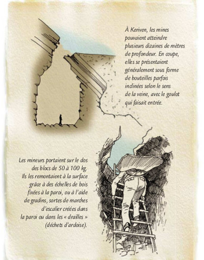
L’exploitation de l’ardoise à Kériven est marquée par le nombre important d’excavations de toutes tailles. En effet, quiconque possédant un droit sur le bois, avait la possibilité d’ouvrir une carrière, ce qui a entraîné un gaspillage de la matière favorisant le déclin de ’exploitation dans la seconde moitié du 19ème siècle.
En 1930, La mise en eau de la retenu de Guerledan noya les principales carrières.
De plus les méthodes employées n'avaient, sans doute, pas évoluées depuis le XVIII éme siècle : pas de treuils, pas de machines pour débiter...Les livraisons se faisaient par charrettes ou par péniches, mais dans un secteur trop limité, et les patrons ne voulaient ou ne pouvaient pas investir.
L'arrivée du chemin de fer sonna le glas des ardoisières de la région car grâce au rail, les ardoises d'Anjou et celles de Mael-Carhaix allaient inonder le marché de Bretagne intérieure.
Le gisement
Le gisement ardoisier de Kériven s’étend sur 1km d’Est en Ouest et est bordé au Nord par le village éponyme et au Sud par le lit du Blavet, aujourd’hui au fond du lac.
Formation de la roche
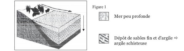
Pour en expliquer la formation, il faut remonter à la géologique de l’ère Primaire (-530 à -235 millions d’années) lorsqu’une mer peu profonde occupait les lieux.
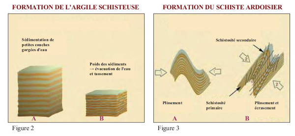
Des dépôts vaseux et sableux issus de l’érosion s’accumulent progressivement au fond des eaux (sédimentation). Puis ces dépôts se sont modifiés sous l’effet de la chaleur et surtout d’une forte pression due aux mouvements de l’écorce terrestre pour devenir des roches métamorphiques.
Globalement, les schistes présentent un aspect feuilleté, lisse et brillant. Par ailleurs, les ardoises de Caurel favorisaient l'oxydation des clous, ce qui indique qu'elle contient beaucoup de minerais de fer.
Le métamorphisme, c’est quoi ?
Le métamorphisme désigne l'ensemble des transformations subies par une roche (sédimentaire, magmatique ou métamorphique) sous l'effet de modifications des conditions de température, de pression, de la nature des fluides et, parfois, de la composition chimique de la roche. Ces transformations, qui peuvent être minéralogiques, texturales, chimiques ou encore structurales, amènent à une réorganisation des éléments dans la roche et à une recristallisation des minéraux à l'état solide.
Les chauves souris
Vous pourrez peut-être apercevoir des chauves souris dans le puits.
En effet, en Bretagne intérieure, il n’existe pas de grottes naturelles. Cependant, on trouve plusieurs espèces de chiroptères cavernicoles. C’est donc dans les mines et galeries abandonnées qu’ils trouvent les conditions de température et d’humidité nécessaires à leur hivernage.
L’été venu, les mâles utiliseront ces cavités pour y passer la journée en attendant la nuit pour chasser les insectes.
Le Circuit
Vous pouvez découvrir la earth cache sur le circuit des chauves-souris et profiter des 6 caches du circuit posées par Tofledev « #Keriven ».
 |
 |
 |

History
Slate mining in the Mûr-de-Bretagne and Caurel region dates back to the 16th century. The monks of the abbey of Bon Repos would be at the origin of this activity.
The exploitation of the slate in Kériven is marked by the large number of excavations of all sizes. Indeed, anyone with a right to the wood, had the opportunity to open a quarry, which resulted in a waste of material favoring the decline of 'exploitation in the second half of the 19th century.
In 1930, the impoundment of the detention of Guerledan drowned the main careers.
Moreover, the methods used had probably not evolved since the 18th century: no winches, no machines to cut ... Deliveries were made by carts or barges, but in a sector too limited, and the bosses did not want or could not invest.
The arrival of the railroad sounded the death knell of the slate of the region because thanks to the rail, the slates of Anjou and those of Mael-Carhaix were going to flood the market of Inner Brittany.
The deposit
The Kieren slate deposit stretches for 1km from East to West and is bordered to the north by the eponymous village and to the south by the bed of Blavet, today at the bottom of the lake.
Formation of the rock
To explain the formation, we must go back to the geological age of the Primary era (-530 to -235 million years) when a shallow sea occupied the site.
Muddy and sandy deposits from erosion gradually accumulate at the bottom of the water (sedimentation). Then these deposits changed under the effect of the heat and especially of a strong pressure due to the movements of the earth's crust to become metamorphic rocks.
Overall, shales have a laminated, smooth and shiny appearance. In addition, the slates of Caurel favored the oxidation of the nails, which indicates that it contains a lot of iron ores.
What is metamorphism ?
Metamorphism refers to all the transformations that a rock undergoes (sedimentary, magmatic or metamorphic) under the effect of changes in the temperature, pressure, fluid nature and sometimes the chemical composition of the rock. These transformations, which can be mineralogical, textural, chemical or even structural, lead to a reorganization of the elements in the rock and to a recrystallization of the minerals in the solid state.
Bats
You may be able to see bats in the well.
In fact, in Brittany, there are no natural caves. However, there are several species of cavernicolous chiroptera. It is therefore in abandoned mines and galleries that they find the conditions of temperature and humidity necessary for their wintering.
In summer, males will use these cavities to spend the day waiting for the night to hunt insects.
The circuit
You can discover the earth cache on the bat circuit and enjoy the 6 caches of the circuit laid by Tofledev "#Keriven".
 |
 |
| Questions |
Questions |
|
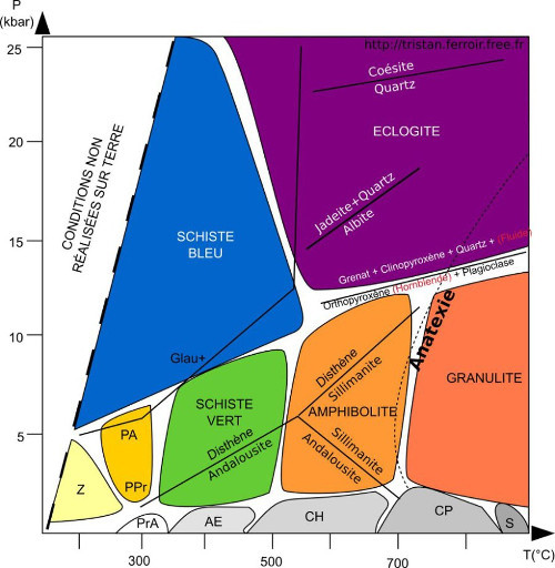
1. Pouvez vous me dire (environ) la pression minimum et le degré minimum qu’il faut pour la formation du schiste ?
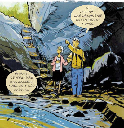
2. Descendez dans le puits. Placez vous face à l'entrée de la mine. Que pouvez vous constatez sur la paroie à votre gauche par rapport à celle de droite ?
3. Au WP1, placez vous le long de la rembarde et observez en contrebas, à gauche. Que voyez vous ?
4. Au WP2, vous voici devant un puits. Son entrée est elle face au lac ?
5. Option : prenez une photo de vous ou de votre GPS devant un des puits.
|
1. Can you tell me (nearly) the minimum pressure and the minimum degree required for shale formation?
2. Go down to the well. Stand facing the entrance to the mine. What can you see on the wall on your left compared to the one on your right ?
3. At WP1, place yourself along the ruffle and look down to the left. What do you see ?
4. At WP2, here you are in front of a well. Is her entrance facing the lake?
5. Option: take a picture of yourself or your GPS in front of one of the wells. |