 En géomorphologie, le terme Tombolo désigne un cordon littoral de sédiments qui relie deux étendues terrestres.
Le dépôt sédimentaire est mis en place par la réfraction du train de vagues due à l’île. Celle-ci protège la zone située entre elle et l’autre étendue terrestre provoquant le dépôt de sédiments.
Les cordons littoraux soudés au littoral par une extrémité sont des pointes libres ou flèches de sable ou de galets. Une pointe libre s’accroche à une île qu’elle relie au continent par sa langue de sable ou de galets et constitue le tombolo. Il est souvent perpendiculaire à la ligne de trait de côte.
Chaque fois que la quantité des sédiments disponibles sur le rivage dépasse le volume des sédiments que les vagues et les courants littoraux peuvent déplacer, le processus d'accumulation (accrétion) l'emporte sur celui de l'érosion.
 In geomorphology, the term Tombolo refers to a shoreline of sediments that connects two terrestrial expanses.
The sedimentary deposit is set up by the refraction of the wave train due to the island. This protects the area between it and the other land area causing sediment deposition.
Coastal cords welded to the coastline at one end are free points or arrows of sand or pebbles. A free point clings to an island that connects to the continent by its tongue of sand or pebbles and constitutes the tombolo. It is often perpendicular to the coast line.
Whenever the amount of sediment available on the shore exceeds the amount of sediment that waves and shorelines can displace, the accumulation process (accretion) outweighs that of erosion.
!!! ATTENTION CACHE UNIQUEMENT ACCESSIBLE A MAREE BASSE !!!
!!! WARNING EARTHCACHE ONLY ACCESSIBLE LOW TIDE !!!
Questions pour valider cette earthcache :
D'après vos observations et à l'aide du desciptif :
Questions to validate this earthcache:
Based on your observations and using the description :
Question 0
Joindre à votre log (PAS à vos réponses) une photo de vous, votre GPS, votre GC perso ou tout autre objet de geocaching aux coordonnées de l'Earthcache (Stage1) obligatoirement avec un élément permettant de reconnaitre le lieu (la Chapelle par exemple).
Les simples photos de paysage ou prises depuis la plage ne permettent pas de valider cette condition de log.
Cette tâche est obligatoire et autorisée par les guidelines mises à jour en juin 2019.
Attach to your log (NOT to your answers) a photo of you, your GPS, your personal GC or any other geocaching object in the game at the posted coordinates (Stage 1), with a recognizable element of the place (the Chapel for example).
Simple landscape photos or photos taken from the beach do not validate this log condition.
This task is mandatory and authorized by the guidelines updated in June 2019.
Stage 1 - N 48° 39.227' W 2° 25.504'
Question 1.
Observez le sol à vos pieds. De quel type d'éléments est-il constitué ?
Watch the ground at your feet. What type of elements is it made of ?
Question 2
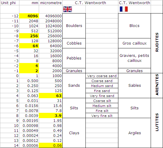
Déterminez la classe granulométrique de ces éléments à l'aide du tableau ci-dessous.
Determine the grain size class of these items using the table below.
Question 3
Déduisez en la vitesse moyenne des courants à l'aide du diagramme ci-dessous.
Deduce at the average speed of the currents using the diagram below.

Stage 2 - N 48° 39.090' W 2° 25.555'
Question 4
Observez le sol à vos pieds. De quel type d'éléments est-il constitué ?
Watch the ground at your feet. What type of elements is it made of ?
Question 5
Déterminez la classe granulométrique de ces éléments à l'aide du tableau.
Determine the grain size class of these items using the table.
Question 6
Déduisez en la vitesse moyenne des courants à l'aide du diagramme.
Deduce at the average speed of the currents using the diagram.
Question 7
Pouvez-vous en conclure à quel Stage les courants sont les plus forts ?
Can you conclude which Stage the currents are the strongest ?
Envoyez-moi vos propositions de réponses soit via mon profil, soit via la messagerie geocaching.com (Message Center) PUIS loguez cette cache "Found it", je vous contacterai en cas de problème.
Assurez vous de répondre à TOUTES les questions ! La condition principale pour loguer une Earthcache étant de répondre aux questions posées dans le descriptif, tout log "Found it" enregistré sans envoi préalable de vos propositions de réponses sera supprimé. Il en sera de même pour les logs enregistrés sans la photo requise.
Send me your proposals for answers either via my profile or via the geocaching.com messaging (Message Center) THEN log this cache "Found it", I will contact you in case of problem.
Make sure to answer ALL questions ! The main condition to log an Earthcache is to answer the questions asked in the description, any log "Found it" registered without prior submission of your proposals of answers will be deleted. It will be the same for logs saved without the required photo.