Sierra Nevada (Español)
Sierra Nevada es una alineación montañosa que ocupa gran parte del sureste peninsular, abarcando desde la provincia de Granada hasta la de Almería. Se extiende de forma longitudinal a lo largo de más de 90 km y su anchura llega a superar los 35 km. Sus cumbres alcanzan la altura de 3482 m en el Mulhacén, lo que la cataloga como el relieve más elevado de la Península Ibérica. El macizo presenta una cierta asimetría, de manera que las laderas del borde norte son más pendientes que las laderas del sur, y las cumbres más elevadas se localizan en el sector occidental del macizo.
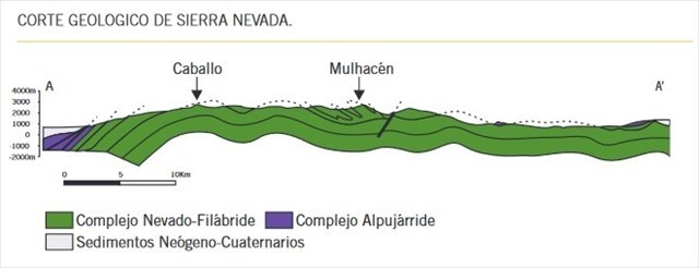
Desde el punto de vista geológico, Sierra Nevada se sitúa en el corazón de las Zonas Internas de la Cordillera Bética.
Estas zonas se componen de tres complejos que se superponen tectónicamente de abajo a arriba: Complejo Nevado-Filábride, Complejo Alpujárride y Complejo Maláguide (Este último, no aflora en este sector, por lo que no lo mencionaremos abajo)
Complejo Nevado-Filábride:
Este complejo, el más bajo tectónicamente, aflora en el núcleo del macizo. Está constituido por las rocas más antiguas, con edades superiores a 250 millones de años.
Complejo Alpujárride:
Representa el conjunto de materiales más extenso de las Zonas Internas, ocupando una posición intermedia en el apilamiento de unidades tectónicas.
Sierra Nevada (English)
Sierra Nevada is a mountain range that occupies much of the southeast of the peninsula, ranging from the province of Granada to the province of Almeria. It extends longitudinally for more than 90 km and its width exceeds 35 km. Its peaks reach the height of 3482 m in the Mulhacén, which classifies it as the highest relief on the Iberian Peninsula. The massif has a certain asymmetry: The slopes of the northern edge are steeper than the southern ones, and the highest peaks are located in the western sector of the massif.
From the geological point of view, Sierra Nevada is located in the heart of the Inner Zones of the Bética Mountain Range.
These zones are composed of three layers that are superimposed tectonically from bottom to top: Nevado-Filábride Complex, Alpujárride Complex and Maláguide Complex (This last one does not appear in this sector, so we will not mention it below)
Nevado-Filábride Complex:
This complex, the lowest tectonically, outcrops in the core of the massif. It is constituted by the oldest rocks, with ages over 250 million years.
Alpujárride Complex:
It represents the most extensive set of materials of the Internal Zones, occupying an intermediate position in the stacking of tectonic units.
Geomorfología de Sierra Nevada (Español)
La sucesión de periodos glaciares e interglaciares que han tenido lugar durante el Cuaternario son responsables de las formas de modelado y paisaje de cumbres de Sierra Nevada. El paisaje de este sector de alta montaña del sur peninsular muestra mayoritariamente una evolución natural. Sin duda, la Última Glaciación y posterior deglaciación han labrado la huella morfológica más significativa en el paisaje actual del macizo.
Además en todo el macizo sólo se preservan las morfologías correspondientes a las últimas grandes glaciaciones cuaternarias (“Mindel”, “Riss” y “Wurm”), así como las de glaciaciones menores ligadas a episodios fríos muy recientes (“Younger Dryas” y “Pequeña Edad del Hielo”)

Sierra Nevada's Geomorphology (English)
The succession of glacial and interglacial periods that have taken place during the Quaternary are responsible for the modeling and landscape forms of the Sierra Nevada peaks. The landscape of this high mountain sector of the south of the peninsula shows a natural evolution. Undoubtedly, the Last Glaciation and subsequent deglaciation have carved the most significant morphological footprint in the current landscape of the massif.
In addition, only the morphologies corresponding to the last great Quaternary glaciations ("Mindel", "Riss" and "Wurm") are preserved in the whole massif, as well as those of minor glaciations linked to very recent cold episodes ("Younger Dryas" and " Little Ice Age")
Estructura Geomorfológica del Mulhacén (Español)
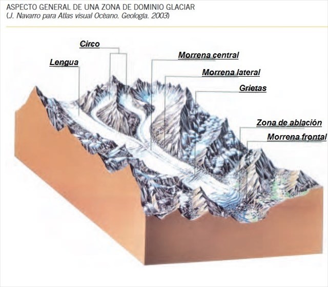
La cumbre del Mulhacen así como el resto de cumbres de Sierra Nevada han sido modeladas intensamente por la acción de masas de hielo permanentes, o glaciares, acumuladas en las altas cumbres, por encima de los 2500 metros de altitud, durante los periodos fríos del Cuaternario. Las huellas de este proceso, formas erosivas y de acumulación, ayudan a entender la dinámica de este sistema morfogenético. Formas en cubeta situadas en la cabecera de los barrancos nos indican la existencia de un circo glacial, el lugar donde la nieve se acumula, se compacta y forma hielo.
La nieve también se acumula valle abajo, formando los glaciares de valle, que se caracterizan por tener una morfología alargada, que se extiende desde el circo hasta la zona de ablación, lugar donde el hielo empieza a fusionarse. La masa desciende a favor de la pendiente aprovechando los valles. Este movimiento provoca un desgaste en la base y paredes del valle, dando lugar a un valle en forma de U, típico de un glaciar. Ejemplos de estas morfologías se observan en las vertientes norte y sur de Sierra Nevada, concretamente en el valle del río Lanjarón, río Seco o el Corral del Veleta.
El desplazamiento del hielo sobre la base del valle genera una serie de efectos sobre las rocas. Los más importantes son: pulimentos, que consisten en superficies uniformes creadas por el roce continuo de los derrubios o el hielo; estrías, grietas lineales, discontinuas, que se originan sobre derrubios o sobre el lecho basal debido al roce (la dirección de las estrías coincide con la dirección de avance de la masa helada) y rocas aborregadas, resaltes rocosos sobre el lecho del valle, muy afectados por la acción abrasiva del hielo, que adquieren un aspecto redondeado.
Mulhacen's geomorphology Estructure (English)
The Mulhacen's summit and the rest of the Sierra Nevada summits have been intensely modeled by the action of permanent ice masses, or glaciers, accumulated in the high peaks, above 2500 meters of altitude, during the cold periods of the Quaternary . The traces of this process, erosive forms and accumulation, help to understand the dynamics of this morphogenetic system. The bucket forms located at the head of the cliffs indicate the existence of a glacial cirque, the place where snow accumulates, compacts and forms ice.
Snow also accumulates down valley, forming valley glaciers, which are characterized by having an elongated morphology, which extends from the circus to the ablation zone, where the ice begins to fuse. The mass descends towards the valleys. This movement causes a wear on the base and walls of the valley, giving rise to a U-shaped valley, typical of a glacier. Examples of these morphologies are observed in the northern and southern slopes of the Sierra Nevada, specifically in the valley of the Lanjarón river, Seco river or the Corral del Veleta.
The displacement of the ice on the base of the valley generates a series of effects on the rocks. The most important are: polishes, which consist of uniform surfaces created by the continuous rubbing of the debris or ice; grooves, linear, discontinuous cracks that originate on washouts or on the basal bed due to rubbing (the direction of the grooves coincides with the direction of advance of the frozen mass) and jagged rocks, rocky ridges on the valley floor, affected by the abrasive action of ice, which acquire a rounded appearance.
Referencias bibliográficas // Bibliographic references
http://digibug.ugr.es/bitstream/handle/10481/41832/Martin_GeologiaSierraNevada.pdf
http://www.ub.edu/geocrit/sn/sn-472.htm
https://www.juntadeandalucia.es/medioambiente/web/ContenidosOrdenacion/red_informacion_ambiental/PDF/Geodiversidad/Geodiversidad_y_Patrimonio_Geologico_Andalucia_2006/capitulo5.pdf
Para reclamar este EarthCache (Español)
1- Haz una foto de tu Móvil, nick o tu GPS en el vértice geodésico (obligatoria según nueva normativa)
Des de la cima y observando los valles que te rodean, podrás ver alguna de las características explicadas en el apartado "GeoMorfología del Mulhacén"
2-Explica cuales ves, hacia que dirección estan y descríbelas con tu propias palabras.
3- ¿Cual crees que es la diferencia entre “Mindel” y “Younger Dryas”
4- ¿Que es un pulimento?
To claim this EarthCache (English)
1- Take a picture of your Mobile, nickname or your GPS in the geodesic vertex (mandatory based on the new guidelines)
From the summit and observing the valleys around you, you will see some of the characteristics explained in the section "Mulhacen's GeoMorphoology"
2-Explain which ones, in which direction they are ... and describe them with your own words.
3- What do you think is the difference between "Mindel" and "Younger Dryas"
4- What is a polish?