Nous voici ici devant une ancienne carrière de schiste exploitée autrefois pour l' empierrement et la construction .
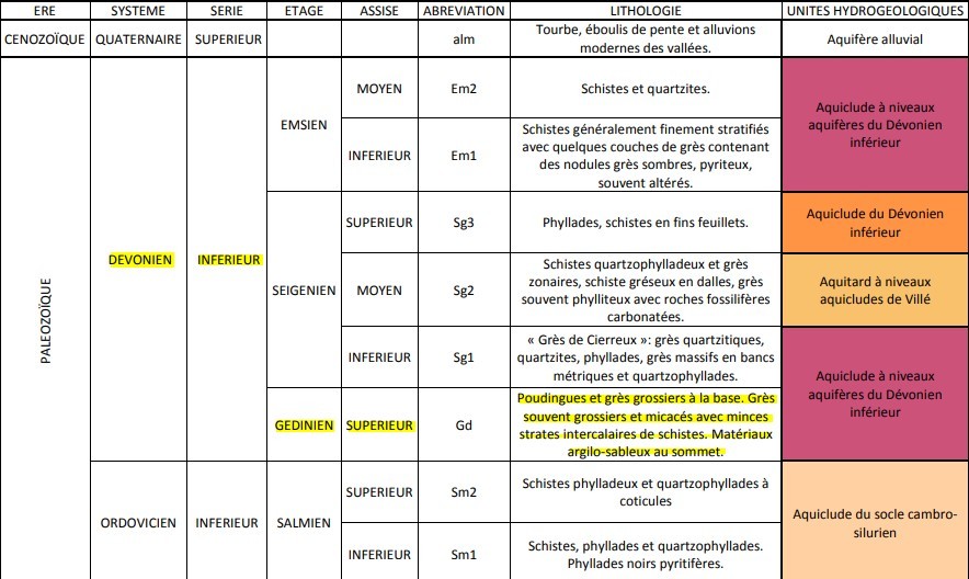
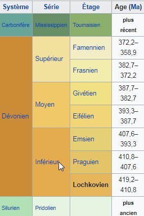
Les terrains affleurants à cet endroit datent du Gédinien Superieur ( partie inférieur du Dévonien ) : c'est à dire qu' ils ont été formés il y a environ 400 millions d' années!
Se sont majoritairement des schistes de Laforet .
Admirez comment certaintes espèces végétales parviennent a coloniser ces sols pourtant peu fertiles : Bouleaux , érables ,genet, digitale pourpre et bruyerè.Aussi quelques hetres et chenes .
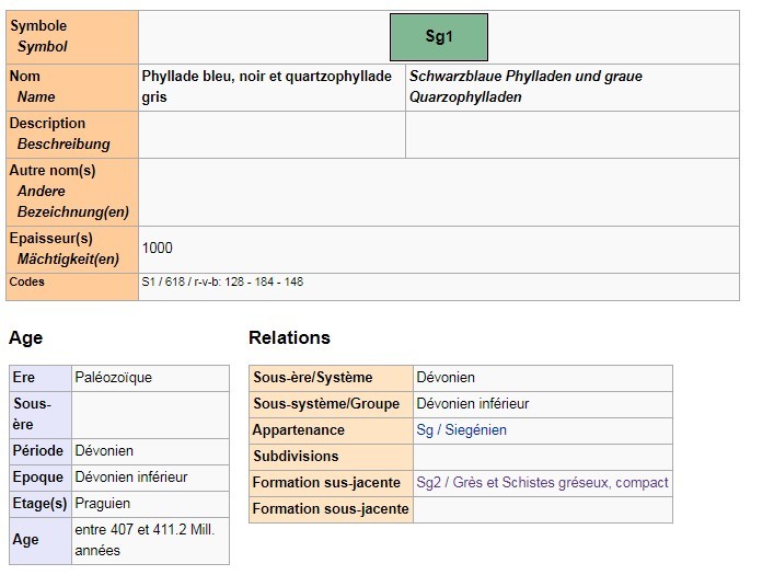
A vos pieds , avez vous remarqué que certains éboulis schisteux ont des fines veines blanches qui ressemblent à du marbre ? Ce sont les quartzophyllades .
Des schistes quartziteux assez grossiers et de fins quartzophyllades ( un type de quartzite )de couleur verdrate , micacés et pyriteux, alternent avec deux lames importante de grès .
Les grès sont en bancs minces , très fracturés , et montrent une allure fortement redressée .
Geologie du gedinien superieur
La Haute Ardenne ou Ardenne s.s. se définit comme un plateau valloné compris entre la bande mésodévonienne de la Calestienne au nord et au sud les séries monoclinales (non plisséer) du Mésozoique situées en bordure du Bassin de Paris. Ce plateau est composé d'un socle "calédonien" sous couverture essentiellement éodévonienne.
Le socle "calédonien" expose des terrains du Paléozoique inférieur ( Cambrien, Ordovicien et Silurien) sous forme de massifs inscrits dans les boutonnières de Rocroi, Serpont, Stavelot et Givonne. Les matériaux, principalement schisteux, ont été déformés une première fois lors de l'orogenèse calédonienne au cours du Silurien supérieur et repris ensuite dans une seconde déformation a la fin du Westphalien au cours de l'orogènese hercynienne. Ces boutonnières affleurent principalement dans les zones culminantes des grands anticlinoria hercyniens de l'Ardenne et de Givonne.
La couverture éodévonienne expose une série sédimentaire discordante sur le socle calédonien. La sédimentation s'échelonne de manière continue sur un temps qui couvre le Gedinnien, le Siegenien et l'Emsien. Les matériaux sont constitués par un conglomérat de base surmonté par des faciès en majorité schisteux incompétents. Ils sont déformés en un train de plis serrés et affectés par une schistosité, tous deux contemporains de l'orogenèse hercynienne. Cette couverture se structure autour des grands anticlinoria de l'Ardenne et de Givonne, ce dernier étant séparé du synclinorium de Neufchateau-Eifel par la faille de charriage d'Herbeumont.
Paléozoique : dévonien inférieur
Le Gedinnien, représente sur cette carte par sa partie supérieure, correspond au Lochkovien dans la nouvelle nomenclature du Dévonien inférieur. Legrand (1965) y distingue, a la base, du poudingue et du grès grossier souvent altéré en kaolin et au sommet, du schiste phylladeux, gris violacé, veiné ou tacheté de vert, avec grès vert souvent grossier en micacé. C'est l'équivalent de la Formation de Waimes de Vandenven (1990) qui, d'après l'auteur, commence par un simple alignement d'a peine 0,3 m de galets issus du socle calédonien surmonté par d'épaisses couches de grès grenu souvent straticulé de lits de gravillons de quartz et de roches arrachés au socle calédonien. Ces roches sont appelées commercialement "Arkoses". Du point de vue pétrographique, le terme ne convient pas a ce grès dont la teneur en éléments feldspathiques n'atteint pas 25%. Le grès forme une série de bancs de 0,50 m d'épaisseur séparés par de minces strates de schistes. Au poudingue et aux grès succèdent des matériaux argilo-sableux.
"Loguez cette cache "Found it" et envoyez-moi vos propositions de réponses soit via mon profil, soit via la messagerie geocaching.com (Message Center), et je vous contacterai en cas de problème."
1) Que sont des Quartzophyllades ?
2) Prenez un morceau de schiste en main et decrivez le .
3) Qu'est-ce qu'une roche métaphorphique ?
facultatif Une photo de vous et/ou votre gps .
Here we are in front of a former shale quarry once exploited for stone and construction.
The flush lands at this location date from the Upper Gedinian (lower Devonian): that is, they were formed about 400 million years ago!
Most of them are Laforet shale.
Admire how certain plant species manage to colonize these poorly fertile soils: birches, maples, broom, foxglove and bruyerè.Also a few beeches and oaks.
At your feet, have you noticed that some schistose scree have fine white veins that look like marble? These are quartzophyllads.
Rough quartzitic shales and fine quartzophyllads (a type of quartzite) of greenish, micaceous and pyritous color, alternate with two large sandstone slats.
The sandstones are thin banks, very fractured, and show a strongly rectified pace.
Geology of the Upper Gedinian
The Haute Ardenne or Ardenne s.s. is defined as a hilly plateau lying between the Mesodevian band of La Calestienne in the north and south of the Mesozoic monoclinal series (non-plisséer) located on the edge of the Paris Basin. This plateau is composed of a "Caledonian" base under essentially Eodévonian cover.
The "Caledonian" basement exposes Lower Paleozoic (Cambrian, Ordovician and Silurian) terrains in the form of massive inscribed in the buttonholes of Rocroi, Serpont, Stavelot and Givonne. The mainly schistose material was deformed a first time during the Caledonian orogeny during the Upper Silurian and then resumed in a second deformation at the end of Westphalian during the Hercynian orogenesis. These buttonholes are mainly exposed in the culminating areas of the great Hercynian anticlinoria of the Ardennes and Givonne.
The Eodevonian cover exposes a discordant sedimentary series on the New Caledonian basement. The sedimentation is staggered continuously over a time that covers the Gedinnian, Siegenian and Emsian. The materials consist of a basic conglomerate surmounted by incompetent schistose facies. They are deformed into a train of tight folds affected by schistosity, both contemporaries of the Hercynian orogeny. This cover is structured around the great anticlinoria of the Ardenne and Givonne, the latter being separated from the Neufchateau-Eifel synclinorium by the Herbeumont thrust fault.
Paleozoic: Lower Devonian
The Gedinnian, represented on this map by its upper part, corresponds to the Lochkovian in the new nomenclature of the Lower Devonian. Legrand (1965) distinguishes at the base from pudding and coarse sandstone, often altered in kaolin and at the top, with phyllite shale, purplish gray, veined or spotted with green, with green sandstone often coarse in micaceous. This is the equivalent of the Waimes Formation of Vandenven (1990) which, according to the author, begins with a simple alignment of barely 0.3 m of pebbles from the New Caledonian basement surmounted by thick layers sandstone grained often stratigraphed beds of quartz chippings and rocks torn from the New Caledonian basement. These rocks are known commercially as "Arkoses". From the petrographic point of view, the term does not suit this sandstone, the feldspar content of which does not reach 25%. Sandstone forms a series of 0.50 m thick banks separated by thin strata of shale. In the pudding and sandstone succeeding clay-sandy materials.
"Log this cache" Found it "and send me your suggested answers either through my profile or via the messaging geocaching.com (Message Center), and I will contact you in case of problems."
1) What are Quartzophyllades?
2) Take a piece of shale in hand and describe it.
3) What is a metaphorphic rock?
optional : A photo of you and / or your gps .