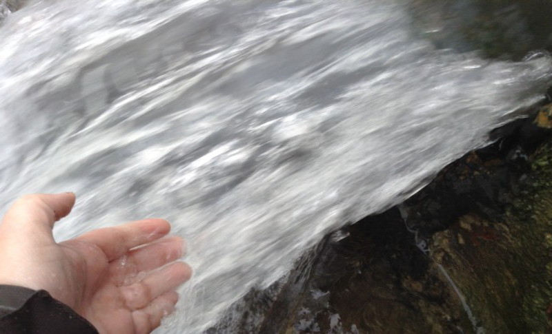
La source d'eau chaude d'Incarville
A Incarville, petite commune de l'Eure, vous vous trouverez en présence d'une source d'eau chaude.
#### Un peu d'histoire
L'abbé Gilbert Delamare, curé de la paroisse en 1929, radiesthésiste à ses heures, se mit en tête de trouver du pétrole sur la commune d'Incarville. Aidé de l'abbé Bouly et financé par le conseiller Général du canton de Beaumont-le-Roger, Georges de Boisgelin, le forage commença.
Un derrick en bois d'une hauteur de 20 mètres fut installé et le forage commença le 10 mars 1931 avec un trépan actionné par une machine à vapeur. Arrivé à une profondeur d'environ 300 mètres, on y trouva du liquide ... mais il s'agissait d'eau et non de pétrole. Convaincu qu'il devait y avoir du pétrole, on continua à creuser jusqu'à 904 m ... mais là encore, ils n'y trouvèrent que de l'eau.
Les travaux cessèrent et un canal fut creusé pour permettre à cette eau de s'écouler jusqu'à la rivière.
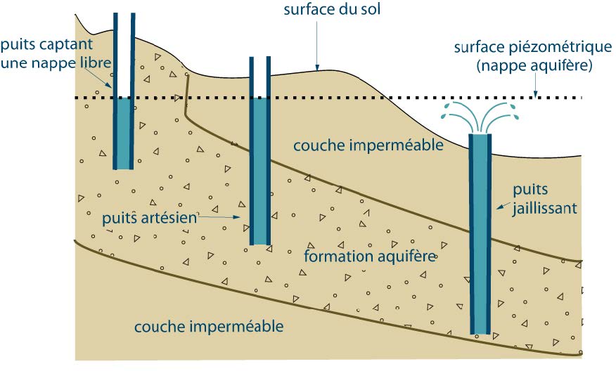
#### Puits de surface ou puits artésien
Les eaux souterraines constituent une provision d'eau potable inestimable pour l'humanité. Quand on parle d'eaux souterraines, on parle des eaux qui se trouvent dans la partie superficielle de la croûte, quelques centaines de mètres au maximum sous terre. Il s'agit des eaux propres à notre consommation. Plus on s'enfonce dans la croûte terrestre, plus l'eau devient riche en divers sels minéraux et métaux, ce qui la rend impropre à la consommation. L'eau souterraine représente une réserve d'eau beaucoup plus abondante que l'eau de surface (lac, rivière, ...).
Si les matériaux du sous-sol sont perméables, les eaux de pluie s'infiltrent et alimentent la nappe phréatique.
La nappe phréatique, une zone où toutes les cavités (pores du sédiment, fractures des roches, cavernes, etc.) sont saturées en eau;
- La nappe est dite libre lorsque son niveau peut varier sans être bloqué par une couche imperméable. Si on crée un puits dans une telle nappe, le niveau de l'eau reste inchangé.
- Une nappe perchée est une nappe libre, permanente ou temporaire, formée dans une zone non saturée, et qui surmonte une nappe libre de plus grande extension.
- Dans le cas contraire, on parle de nappe captive. Elle est « sous pression » et lorsque l'on y ouvre un puits, l'eau s'élève jusqu'à un niveau d'équilibre supérieur.
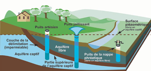
L'approvisionnement en eau à la surface peut se faire par deux types de puits :
- le puits de surface
- le puits artésien
Le puits de surface est un puits qui s'approvisionne directement dans la nappe phréatique par pompage. Le pompage dans un puits de surface a pour effet de former autour du puits un cône de dépression. Un excès de pompage abaissera le niveau phréatique et pourra contribuer à assécher d'autres puits avoisinants.
Le puits artésien est un puits où l'eau jaillit spontanément. Le puits artésien est obtenu en perforant une couche de sol ou de roc imperméable.
Si ce forage a lieu sous la ligne piézométrique (ligne de niveau supérieur de la nappe phréatique), l’eau jaillit du puits.
Si la bouche du puits se situait au-dessus de la surface piézométrique, il n'y aurait pas de jaillissement; l'eau atteindrait dans le puits la hauteur de la surface piézométrique.
Le puits artésien est habituellement fiable et stable toute l'année pour ce qui est de la quantité d'eau.
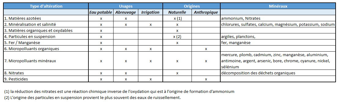
#### L'altération des eaux souterraines
La nature géologique du terrain a une influence déterminante sur la composition chimique de l’eau. À tout instant, l’eau est en contact avec le sol dans lequel elle stagne ou circule : il s’établit un équilibre entre la composition du terrain et celle de l’eau.
Le système d'évaluation de la qualité des eaux (SEQ) classe les eaux en fonction de l'altération principale qu'elle subit et est utilisé pour préciser le type d'usage qu'il pourra être fait (ou non) de l'eau. Ainsi 9 catégories se dessinent. Ces catégories, leurs usages et leurs origines sont présentées dans le tableau ci-dessous.
#### Géothermie
Les sources d'eaux chaudes constituent une source d'énergie thermique "gratuite".
Les nappes phréatiques sont en effet de bons réservoirs d'énergie car leurs températures restent relativement stables tout au long de l'année. Le principal problème c'est la difficulté pour capter cette énergie, car il faudra creuser un puits, parfois à de grandes profondeurs, d'où un surcoût financier. Certaines nappes sont très chargées en minéraux ce qui peut également entraîner des surcoûts liés à leur traitement (oxydation des pompes, ...).
Les nappes souterraines peu profondes (de quelques dizaines à quelques centaines de mètres) présentent des températures qui varient de 12 à 60° C selon la profondeur. A des profondeurs un peu plus importantes (de 500 à 2000 m environ) on trouve des nappes d’eau à des températures situées entre 40 et 90° C.
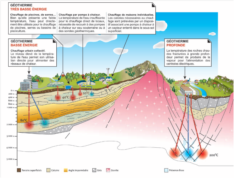
Le schema ci-dessous présente des exemples types d'utilisation de la géothermie.
|
Pour loguer cette cache :
Pour valider votre visite sur le site, envoyez-moi vos réponses par mail ou centre de messagerie aux questions suivantes. Vous pouvez loguer "Found it" sans attendre mon accord, je vous contacterai si nécessaire.
Q0. Optionnel, une photo de vous ou de votre GPS sur les lieux sera fortement appréciée.
Q1. A Incarville, sommes-nous en présence d'un puits artésien ou d'un puits de surface ?
Q2. Le puits ainsi foré a-t-il atteint une nappe libre, une nappe perchée ou une nappe captive ?
Q3. Lorsque le forage atteignit la profondeur de 300 mètres, était-on déjà sous la ligne piézométrique ou non ? Comment justifiez-vous votre réponse ?
Q4. Quelle est la composition principale de l'eau de source d'Incarville (citez deux éléments) ?
Q5. Si l'on prend en compte la composition principale de l'eau d'Incarville en sortie du puits, à quel type principal d'altération sommes-nous confrontés ?
Q6. A votre avis, lequel des deux éléments est à l'origine de la "couleur" particulière que prend l'eau à la sortie du puits dans le petit chenal ? Quelle est cette "couleur" ?
Q7. La température de l'eau en sortie du puits est-elle constante ou peut-elle varier ?
Q8. A la source d'Incarville, il a été envisagé de récupérer cette chaleur pour chauffer les bâtiments communaux. Pour quelle raison le projet fut-il abandonné ?
|
The hot spring of Incarville
In Incarville, a small town in the department of Eure, you will find a hot spring.
#### History of the spring
The parish Gilbert Delamare, in 1929, also radiesthesist, began to find oil in the town of Incarville. Assisted by Fr. Bouly and funded by Beaumont-le-Roger County Councilor, Georges de Boisgelin, the drilling began.
A wooden derrick 20 meters high was installed and drilling began on March 10, 1931 with a drill bit powered by a steam engine. At a depth of about 300 meters, there was liquid ... but it was water and not oil. Convinced that there must be oil, we continued to dig up to 904 m ... but again, they found only water.
Work ceased and a canal was dug to allow this water to flow to the river.
#### Surface well or artesian well
Groundwater is an invaluable supply of drinking water for humanity. When we talk about groundwater, we are talking about the waters that are in the superficial part of the crust, a few hundred meters underground. These are the waters that are suitable for our consumption. The deeper we sink into the earth's crust, the more water becomes rich in various minerals and metals, making it unsuitable for consumption. Groundwater represents a much more abundant water reserve than surface water (lake, river, ...).
If the subsoil materials are permeable, the rainwater infiltrates and feeds the water table.
The water table, an area where all cavities (sediment pores, rock fractures, caves, etc.) are saturated with water;
The web is called free when its level can vary without being blocked by an impermeable layer. If a well is created in such a water table, the water level remains unchanged.
- A perched sheet is a loose web, permanent or temporary, formed in an unsaturated zone, and which overcomes a free web of greater extension.
- In the opposite case, we speak of captive . It is "under pressure" and when a well is opened, the water rises to a higher equilibrium level.
The water supply to the surface can be done by two types of wells:
- the surface well
- the artesian well
The surface well is a well that gets its supplies directly from the water table by pumping. Pumping into a surface well has the effect of forming a cone of depression around the well. Excessive pumping will lower the groundwater level and may help dry out other nearby wells.
The artesian well is a well where water gushes spontaneously. The artesian well is obtained by perforating a layer of soil or impervious rock.
If this drilling takes place under the piezometric line (upper level line of the water table), water gushes from the well.
If the mouth of the well was above the piezometric surface, there would be no spurt; the water would reach into the well the height of the piezometric surface.
The artesian well is usually reliable and stable year round in terms of the amount of water.
#### Alteration of groundwater
The geological nature of the ground has a decisive influence on the chemical composition of the water. At all times, the water is in contact with the soil in which it stagnates or circulates: a balance is established between the composition of the ground and that of the water.
The water quality assessment system (SEQ) classifies the waters according to the main alteration it undergoes and is used to specify the type of use that can be made (or not) of the water. Thus 9 categories are drawn. These categories, their uses and their origins are presented in the table below.
#### Geothermy
Hot springs are a source of "free" thermal energy.
Groundwater is indeed a good reservoir of energy because its temperatures remain relatively stable throughout the year. The main problem is the difficulty of capturing this energy, because it will be necessary to dig a well, sometimes at great depths, resulting in additional financial costs. Some tablecloths are very loaded with minerals which can also lead to additional costs related to their treatment (oxidation of pumps, ...).
The shallow groundwater (from a few tens to a few hundred meters) has temperatures ranging from 12 to 60 ° C depending on the depth. At slightly larger depths (from 500 to 2000 m approximately) we find water tables at temperatures between 40 and 90 ° C.
The diagram below shows some typical examples of geothermal use.
|
To log this cache :
To validate your visit on the site, send me your answers by mail or message center to the following questions. You can log in "Found it" without waiting for my agreement, I will contact you if necessary.
Q0. Optional, a photo of you or your GPS in this location will be highly appreciated.
Q1. At Incarville, are we in presence of an artesian well or a surface well ?
Q2. Has the well thus drilled reached a loose sheet, a perched sheet or a captive sheet ?
Q3. When the drilling reached the depth of 300 meters, was it already below the piezometric line or not? How do you justify your answer ?
Q4. What is the main composition of Incarville spring water (find two elements) ?
Q5. If we take into account the main composition of Incarville water coming out of the well, what is the main type of deterioration we are facing ?
Q6. In your opinion, which of the two elements is at the origin of the particular "color" that water takes when leaving the well in the small channel? What is this "color" ?
Q7. Is the water temperature at the outlet of the well constant or can it vary ?
Q8. At the spring of Incarville, it was envisaged to recover this heat to heat the communal buildings. Why was the project abandoned ?
|