Le sous sol de la commune de Riec sur Belon est essentiellement composé de roches métémorphiques datant de l’Ordovicien inférieur. C’est la plus ancienne époque de l’Qrdovicien s’étendant de 485,4 ± 1,9 à 470,0 ± 1,4 million d’années, à l’ère Paléozoïque.
Une roche métamorphique est un type de roches dont la formation a pour origine la transformation à l'état solide des roches sédimentaires, magmatiques ou encore métamorphiques, en raison des modifications des paramètres physico-chimiques du milieu dans lequel elles évoluent (notamment la pression et la température). Cette transformation, désignée sous le terme de métamorphisme, se traduit par une modification de la texture, de l'assemblage minéralogique à l'équilibre ou de la composition chimique de la roche. La roche originelle d'une roche métamorphique est appelée le protolithe.
D’après la carte géologique source BRGM n° 382 de Concarneau , nous pouvons déterminer plusieurs caractéristiques géologiques du secteur encore plus précises que je vous propose de découvrir avec la parution de cette earthcache.
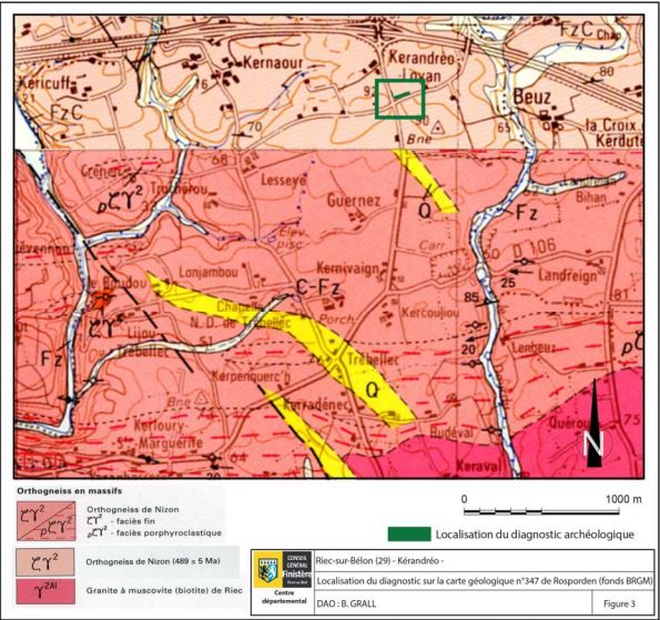
La zone Y2AI, au sud de la carrière de Kernivaigne, est une zone de granite à muscovites (biotite), terrain propice aux cultures céréalières et aux prairies.
La zone CY2 , sur laquelle vous vous trouvez, est une zone d’orthogneiss de Nizon composée de gneiss gris clair, d’origine magmatique de grain fin à moyen, micacé finement feuilletée avec exsudas de quartz, qui dans cette zone, outre de la biotite et du grenat, on la particularité de comporté de la sillimanite. Il est recouvert de limon argileux jaune à sable grossier plus ou moins épais et d’une couche de terre végétale comprise entre 0,1 et 0,5 m d’épaisseur
La zone Q est un filon de quartz, voici sa définition: Lame de roche, épaisse de quelques centimètres à quelques mètres, recoupant les structures de l’encaissant. Le filon correspond le plus souvent au remplissage d’une fracture.
Maintenant, je vous propose de revenir à cette zone CY2 où nous nous trouvons. Vous êtes devant l’entrée de la carrière de Kernivaigne. Cette carrière est toujours en exploitation, Elle produit chaque année 450 000 tonnes de granulats à partir de deux fosses. La roche (du gneiss) est abattue par des tirs de mines et la fouille se décompose en quatre paliers successifs d'une hauteur de 15 mètres chacun. Je vais vous parler des matériaux que nous y trouvons… Regardez bien !
Le sable et le gravier…
Le sable est un matériau granulaire constitué de petites particules provenant de la désagrégation d'autres roches dont la dimension est comprise entre 0,063 (limon) et 2 mm (gravier) selon la définition des matériaux granulaires en géologie. Sa composition peut révéler jusqu'à 180 minéraux différents (quartz, micas, feldspaths) ainsi que des débris calcaires de coquillage et de corail.
Le gravier est une roche détritique meuble, d'un diamètre compris entre 2 et 20 mm environ.
Mais savez-vous que ces matériaux font partie de ce que l’on appelle les granulats ? Vous connaissez ?
Eh bien je vous propose d’en savoir un peu plus sur ces matériaux que l’on rencontre tous les jours et qui ont une importance capitale dans notre vie quotidienne !
DE LA ROCHE... AU PETIT GRAIN DE SABLE
Les granulats sont élaborés par le producteur à partir de gisements de roches massives d'origines géologiques diverses (cornéennes, gneiss, grès...) ou de gisements de roches meubles (pliocène, alluvions...).
Dans le premier cas, l'élaboration des granulats nécessite l'emploi maîtrisé d'explosifs pour détacher la roche de son massif et la fragmenter au maximum. Une succession d'opérations automatisées de concassage, criblage et lavage permet d'obtenir une gamme de granulats de différents calibres (granulométries) répondant aux diverses utilisations, jusqu'au plus petit "grain de sable".
L'élaboration des granulats de roches meubles - familièrement appelés granulats roulés - ne nécessite pas l'emploi d'explosifs et très peu de concassage. Par contre, leur lavage pour les débarrasser de la gangue argileuse qui les enrobe est une opération essentielle.
Des granulats sont également élaborés à partir de gisements marins "dragués" au moyen de navires sabliers ou encore par recyclage des bétons de démolition.

LES FAMILLES DE GRANULATS
Sables
Graviers, Gravillons, Cailloux
Graves, Tout-venant, Ballast
Blocages, Enrochements
LES UTILISATIONS DU GRANULAT
LES GRANULATS POUR CHAUSSÉES
Les granulats entrent dans la composition des différentes couches qui forment la structure des routes, de la couche de forme à la couche de roulement où ils sont directement en contact avec les pneus des véhicules. Le granulat peut être utilisé seul ou enrobé d'un liant : ciment ou bitume.
1 kilomètre d'autoroute = 30 000 tonnes de granulats
Pour la confection des chaussées, en particulier pour la couche d'assise, le producteur peut être amené à mélanger différents calibres de granulats pour composer un matériau dénommé "grave", traité au liant ou non. La grave assure une bonne cohésion d'ensemble de la chaussée indispensable pour répondre correctement et durablement aux sollicitations du trafic routier.
LES GRANULATS POUR BÉTONS ET MORTIERS
Les granulats entrent aussi dans la fabrication des bétons : bétons prêts à l'emploi et béton manufacturé (parpaings, tuyaux, poutrelles, dalles...) auxquels ils apportent la consistance, le volume et la résistance.
1m3 de béton = 2 tonnes de granulats
LES GRANULATS POUR VOIES FERRÉES
C'est également avec les granulats qu'on réalise le ballast des voies ferrées.
1 kilomètre de voie ferrée = 10 000 tonnes de granulats
Waypoint 1 : N47°52.379 W003°41.484
Vous êtes à l’entrée de la carrière.
Question 1
Pouvez-vous me décrire quels types de granulats vous pouvez observer depuis cette entrée ?
Waypoint 2 : N47°52.367 W003°41.523
Question 2 :
Dite moi en partant de la gauche vers la droite tous les type de granulats que vous voyez ?
Waypoint 3 : N47°52.332 W003°41.573
Question 3 :
Décrivez ce que vous voyez devant vous et quel type de granulats se trouve sur la droite de l’entrée ?
Waypoint 4 : N47°52.322 W003°41.693
Question 4 :
Décrivez ce que vous voyez devant vous ? Quel est la couleur du gneiss ? Et pourquoi ?
Waypoint 5 : N47°52.328 W003°41.694
Question 5 :
Décrivez ce que vous voyez devant vous ? Quel est la couleur du gneiss ? Et pourquoi ?
Pour finir, une photo de vous, prise devant cette belle zone, serait la bienvenue, même si c'est facultatif.

Orthogneiss in Kernivaigne
The basement of the town of Riec sur Belon is mainly composed of metamorphic rocks dating from the lower Ordovician. It is the oldest period of the Qrdovician, extending from 485.4 ± 1.9 to 470.0 ± 1.4 million years ago, in the Paleozoic era. p>
A metamorphic rock is a type of rock whose formation originates from the solid state transformation of sedimentary, magmatic or metamorphic rocks, due to changes in the physico-chemical parameters of the environment in which they evolve (in particular the pressure and temperature). This transformation, referred to as metamorphism, results in a modification of the texture, the equilibrium mineral assemblage or the chemical composition of the rock. The original rock of a metamorphic rock is called the protolith.p>
D’après the BRGM source geological map n ° 382 of Concarneau , we can determine several geological features of the sector even more precise that I propose to discover with the release of this earthcache.
Zone Y2AI, south of Kernivaigne quarry, is a zone of granite with muscovites (biotite), a suitable ground for cereal crops and grasslands.
Zone CY2, on which you are located, is an area of Nizon orthogneiss composed of light gray gneiss, of magmatic origin of fine to medium grain, micaceous finely laminated with exsudas of quartz, which in this zone, besides the biotite and garnet, there is the peculiarity of sillimanite. It is covered with yellow clay loam with coarse sand of varying thickness and a layer of topsoil between 0.1 and 0.5 m thick
Zone Q is a quartz vein, here is its definition: Blade of rock, thick from a few centimeters to a few meters, intersecting the structures of the casing. The vein most often corresponds to the filling of a fracture.
Now, I propose to return to this A2 area where we are. You are in front of the entrance to Kernivaigne's quarry. This quarry is still in operation. It produces 450,000 tonnes of aggregates each year from two pits. The rock (gneiss) is shot by mine fire and the excavation is broken down into four successive stages with a height of 15 meters each. I will tell you about the materials we find there ... Look well!
Sand and gravel...
Sand is a granular material made up of small particles resulting from the disintegration of other rocks whose size is between 0.063 (silt) and 2 mm (gravel) according to the definition of granular materials in geology. Its composition can reveal up to 180 different minerals (quartz, micas, feldspar) as well as calcareous debris of shell and coral.
Gravel is a loose detrital rock with a diameter of between 2 and 20 mm.
But do you know that these materials are part of what are called aggregates? You know?
Well I suggest you to know a little more about these materials that we meet every day and that are of capital importance in our daily life!
FROM THE ROCK ... TO THE SMALL GRAIN OF THE SAND ROCK
The aggregates are elaborated by the producer from deposits of massive rock of various geological origins (corneennes, gneiss, sandstone ...) or deposits of soft rocks (Pliocene, alluvium ...).
In the first case, the preparation of aggregates requires the controlled use of explosives to detach the rock from its massif and to fragment it to the maximum. A succession of automated crushing, screening and washing operations allows to obtain a range of aggregates of different sizes (particle sizes) corresponding to the various uses up to the smallest "grain of sand".
The production of aggregates of loose rock - colloquially called rolled aggregates - does not require the use of explosives and very little crushing. On the other hand, their washing to get rid of the clay matting that coats them is an essential operation.
Aggregates are also produced from "dredged" marine deposits using hourglass vessels or by recycling demolition concretes.
GRANULATE FAMILIES
Shortbread
Gravel, Gravel, Stone
Graves, All-in, Ballast
Locks, Riprap
USES OF THE GRANULATE
• GRANULATES FOR PAVEMENTS
The aggregates are used in the composition of the various layers which form the structure of the roads, from the shape layer to the tread layer where they are directly in contact with the tires of the vehicles. The granulate can be used alone or coated with a binder: cement or bitumen.
1 km of motorway = 30 000 tonnes of aggregates
For the preparation of roadways, in particular for the seating layer, the producer may be required to mix different grades of aggregates to form a material called "gravel", treated with or without the binder. The bass ensures a good overall cohesion of the pavement indispensable to respond correctly and durably to the stresses of road traffic.
• GRANULATES FOR CONCRETE AND MORTARS
Aggregates are also used in the manufacture of concretes: ready-mixed concrete and manufactured concrete (breeze blocks, pipes, beams, slabs ...) to which they provide consistency, volume and strength.
1m3 of concrete = 2 tons of aggregates
• GRANULATES FOR RAILWAYS
It is also with the aggregates that the track ballast is realized.
1 kilometer of track = 10,000 tonnes of aggregates
To validate this earthcache, I will ask you to move to 5 places, not very far from each other and respond by email or geocaching to the following questions. You can log in "Found it", and I'll contact you if necessary.
Waypoint 1: N48 ° 05.282 E000 ° 31.490
You are at the entrance to the quarry.
Question 1
Can you describe what types of aggregates you can see from this entrance ?
Waypoint 2 : N47°52.367 W003°41.523
Question 2 :
Tell me from the left to the right all the type of aggregates you see? p>
Waypoint 3 : N47°52.332 W003°41.573
Question 3 :
Describe what you see in front of you and what type of aggregate is on the right of the entrance ?
Waypoint 4 : N47°52.322 W003°41.693
Question 4 :
Describe what you see in front of you ? What is the color of the gneiss ? And why ?
Waypoint 5 : N47°52.328 W003°41.694
Question 5 :
Describe what you see in front of you ? What is the color of the gneiss ? And why ?
Finally, a photo of you, taken in front of this beautiful area, would be welcome, even if it is optional.