For many years we’ve observed this amazing sight while crossing the Salish Sea (Strait of Georgia) between Metro Vancouver and Vancouver Island. You may also have seen it, and simply not known about it.
Well here’s the opportunity to not only learn all about this fascinating phenomena, but get a smile on your map for it too!
Important Information Needed to Complete This T5 Earthcache - Please Read First!
This is a T5 Earthcache as you will require access to a boat to make the observations requested. Fortunately, that boat can be a BC Ferry, on the run from Tsawwassen to Duke Point (or vice-versa). If you are fortunate enough to have access to a seaworthy boat, you can travel to the general area of the coordinates.
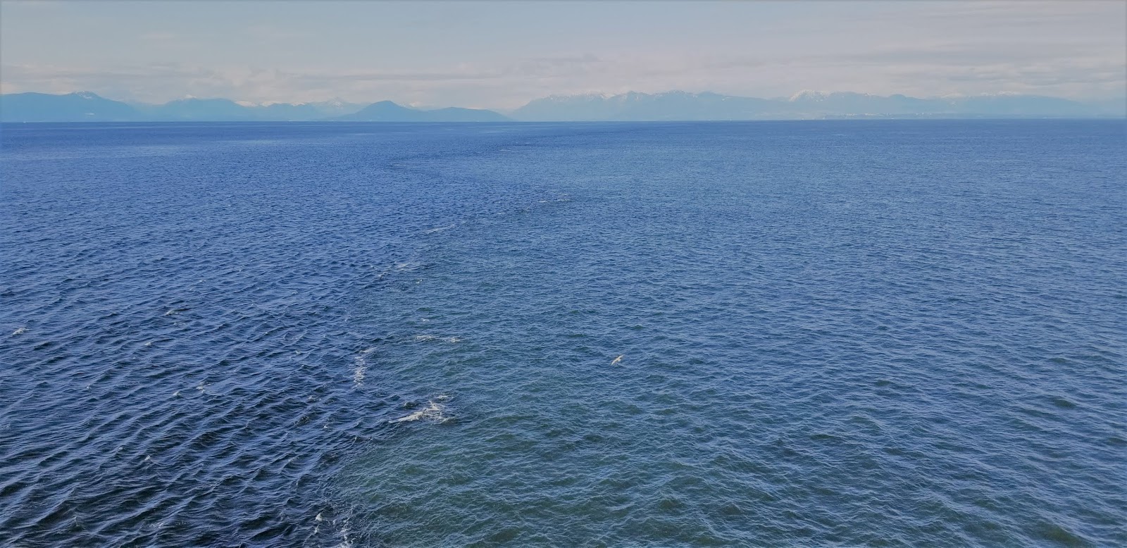
Near the midpoint of the BC Ferry route across the Salish sea to Duke Point, you can observe an extremely distinct and abrupt change in the water. This change is the edge of the Fraser River Plume. Viewing the area via Google Earth it will seem like you can observe the plume much closer to the shore of the mainland, but this is due to overlaying map images and is not accurate. Do not use Google Earth images or data to answer these earthcache questions as you’ll likely get them wrong.
Please note that due to the very nature of the plume the Earthcache coordinates are approximate, and you WILL need to observe and watch for the plume edge during the mid-section of the ferry ride, so watch carefully! This will be extremely difficult to observe on night crossings; we recommend a day crossing to make your observations.
What is the Plume?
“The Fraser River plume is the brackish surface layer formed when the Fraser River discharges into the Strait of Georgia.”
The high sediment loads of the Fraser River combined with the fast discharge into the Salish Sea are the two most significant contributing factors in the creation of the plume. Sediment loaded water from the Fraser moves out over the Salish Sea/Strait of Georgia creating the amazing phenomena.
The plume size and shape varies throughout the year and from year to year due to various mitigating factors. J.A. Stronach’s research on the topic has this to say:
“Fraser River discharge varies seasonally from 1000 m3/second to 10,000 m3/second, and is also tidally modulated. As the river water spreads out over the Strait, its motion is strongly affected by winds and tides, and the geometry of the river mouth area; there are shallow drying banks along one side of the river mouth, and a solid jetty along the other.”
How is the Plume Created?
The Fraser River and its various tributaries cut through most of the enormous Province of British Columbia, and bring thousands of tons of sediment down river to its terminus in the Salish Sea (Strait of Georgia).
As noted above, the plume is the result of the vast amount of sediment bearing water rushing from the brackish water of the Fraser River into the salt water of the Fraser River.
Because the water from the Fraser River varies in its salt levels (salinity) from between 0% to ~28%, there is an effect on the sediment carrying water (that of lower salinity, coming from the Fraser River).
Now, as saltwater is more dense than brackish or freshwater, the sediment carrying water from the Fraser tends to be more buoyant and layer “on top” of the salt water in the Salish Sea. This creates the plume, which can vary in thickness from mere centimetres to up to 10m.
The currents in the Salish Sea and other weather conditions all combine to create a distinct frontal structure to the plume, which is the line we are observing in this earthcache.
Who Studies the Plume?
Since the 1960s oceanographers have studied the plume, but in 2013 a radar system was installed to measure surface currents.
“Ocean Networks Canada has also installed the Seakeeper seawater monitoring system on the BC Ferries MV Queen of Alberni to collect detailed information of water properties along the Duke Point – Tsawwassen ferry route which cuts through the plume eight times per day. These new observations, coupled with satellite imagery, are being used by UBC researchers Dr. Mark Halverson and Prof. Rich Pawlowicz to reveal the nature of the Fraser plume. The research is being carried out as part of the Marine Environmental Observation Prediction and Response Network (MEOPAR), which is tasked with improving Canada’s ability to respond to marine hazards.”
All of this research combines to help us better understand how the plume is created, how it behaves in varying environmental and geological influences, and what impacts it has on the ocean and its inhabitants.
Now it’s your turn to do a little research and earn your smile!
Questions:
For question #1, please include those answers (not those for questions 2-5) in your log, along with a picture if you are so inclined.
1. Research continues on the movement of the plume. Contribute to that research by posting in your cache log the GPS coordinates, time, and date you crossed the edge of the plume.
For the following questions, please send them to me via the Geocaching.com message centre or email, do not include the answers to these questions in your log.
2. Name the ship that Ocean Networks Canada has installed the Seakeeper seawater monitoring system on.
3. Describe the colour differences between the sides of the plume.
4. From your observation point, what direction does the edge of the plume run?
5. What geological processes contribute to the existence of the plume, and why does it vary in shape and colour?
Citing Sources:
https://www.sciencedirect.com/science/article/pii/0302184X81900391
http://www.oceannetworks.ca/fraser-river-plume