
This earthcache is located next to the Obri dul in National park Krkonose (Giant Mts.).
Tahle earthcache sa nachazi pri Obrim dole v Krkonosskem narodnim parku.
Dieser Earthcache befindet sich im Obri dul im Nationalpark Karkonoski (Riesengebirge).
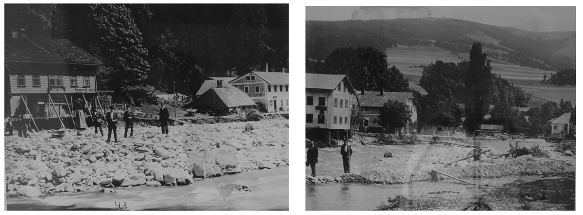

EN: Debris flows are geological phenomena in which water-laden masses of soil and fragmented rock rush down mountainsides, funnel into stream channels, entrain objects in their paths, and form thick, muddy deposits on valley floors. They generally have bulk densities comparable to those of rock avalanches and other types of landslides (roughly 2000 kilograms per cubic meter), but owing to widespread sediment liquefaction caused by high pore-fluid pressures, they can flow almost as fluidly as water. Debris flows descending steep channels commonly attain speeds that surpass 10 m/s, although some large flows can reach speeds that are much greater.
Debris flows can be triggered by intense rainfall or snowmelt, by dam-break or glacial outburst floods, or by landsliding that may or may not be associated with intense rain. In all cases the chief conditions required for debris flow initiation include the presence of slopes steeper than about 25 degrees, the availability of abundant loose sediment, soil, or weathered rock, and sufficient water to bring this loose material to a state of almost complete saturation.
Structural debris flows were found throughout Bohemia only in the Giant Mountains - most of them here in the Obří důl.
If you want to log this cache, you have to complete these tasks:
1. Arrived at the Earthcache's coordinates, look around. At the opposite slope you can see debris flows. How many do you see? Please describe what you see (size, dimension, structure).
2. Describe in your own words how debris flows occur.
3. Go to the coordinates of the chapel (waypoint 1). There you will find a board explaining the last debris flow observed in the valley. Especially here in the giant ground there are a lot of them. How many have been described so far?
4. Describe in your own words why the mudslide behaves like a liquid despite solid material is being moved? (keyword thixotropy)
5. You can add a photo of yourself or your GPS to your log (optionally) - please try not to spoil.
Send us your answers via our profile. You don't have to wait for clearance. If something is wrong, we will contact you.

CZ: Mura nebo též blokovobahenní proud je katastroficky rychlý svahový proud tekoucí hmoty, tvořený jemnozrnným materiálem přesyceným vodou, s úlomky až bloky skalních hornin. Rychlost takového proudu se pohybuje v širokém rozpětí od jednotek km/h po více než 10 m/s. Příčinou vzniku mury je přesycení svahu vodou, které může být způsobeno intenzivními dešťovými srážkami nebo táním sněhové krývky. Podmínkou vzniku mury je dostatečný sklon svahu a dostatečná vrstva sedimentů na svahu.
Mura je rychlý pohyb směsi sedimentu a vody po svahu. Jde o jeden z typů gravitačního transportu. K jeho vzniku je nezbytná přítomnost vody a významného podílu jemnozrnné frakce v hornině. Mury bývají způsobeny vnějšími silami, např. intenzivními srážkami nebo otřesy půdy, případně rychlou sedimentací na nestabilních svazích. Mohou nabývat i katastrofických rozměrů.
Mury byly nalezeny v Čechách pouze v Krkonoších a největši počet právê tady v Obřím dole.
Pro uznani logu na tehle earthcache musite splnit následujících úkolů:
1. Když se nacházíte na souřadnicích Earthcache, rozhlédněte se kolem sebe. Na protilehlém svahu můžete vidět toky sutiny. Kolik jich vidíte? Prosím, popište, co vidíte (velikost, rozměr, strukturu).
2. Popište vlastními slovy, jak mohou proudit zbytky sutin.
3. Běžte na souřadnice kaple (bod 1/waypoint 1). Zde naleznete tabulku, která vysvětluje poslední toky suti v údolí. Ve zdejším terénu jich je obzvláště mnoho. Kolik jich bylo dosud popsáno?
4. Popište vlastními slovy, proč se tok sutin/trosek chová jako kapalina, ačkoli se pohybuje jako pevný materiál? (klíčovým slovem je tixotropie)
5. Neváhejte a fotografii z vás nebo vaše GPS připojit protokol (volitelně) - zkuste to prosím nekazí.
Odpovědi zasílejte přes kontaktní email (nečekejte na potvrzení a logujte, pokud bude něco špatně, ozveme se).

DE: Eine Mure ist ein schnell talwärts fließender Strom aus Schlamm und gröberem Gesteinsmaterial im Gebirge, physikalisch vergleichbar mit einer sehr groben Suspension. Muren haben einen hohen Feststoffgehalt und dadurch bedingt eine hohe Dichte (bis 2,6 g/cm3). Eine Mure kann einige hunderttausend Kubikmeter Material transportieren. Durch ihre Energie kann sie große Verwüstungen anrichten. Die meist klar ausgeprägte Front kann eine Geschwindigkeit von bis zu 10 m/s erreichen.
Eine Mure entsteht im Gebirge, wenn im steilen Gelände wenig verfestigtes Material (Geröll, Schutt und Erdmaterial) wasserübersättigt wird und, meist allein durch Einwirkung der Schwerkraft, in Bewegung gerät. Ausgelöst wird die Durchnässung meistens durch starke oder lang anhaltende Niederschläge oder die Schneeschmelze, zunehmend jedoch auch durch das Abschmelzen von Gletschern oder Permafrostböden durch die Erderwärmung. Muren folgen meist bestehenden Bachbetten oder Rinnen und erweitern sie stark, sie können aber auch eine neue Rinne graben.
Strukturelle Muren wurden in ganz Böhmen nur im Riesengebirge gefunden - die meisten von ihnen hier im Obří důl.
Um den Cache loggen zu können, beantworte bitte folgende Fragen:
1. Wenn du an den Koodinaten des Earthcache stehst, schau dich um. Am gegenüberliegenden Hang kannst du Murenabgänge sehen. Wie viele siehst du? Beschreibe bitte was du siehst (Größe, Ausmaß, Struktur).
2. Beschreibe in deinen eigenen Worten, wie es zu Murenabgängen kommen kann.
3. Gehe zu den Koordinaten der Kapelle (Wegpunkt 1). Darin findest du eine Tafel mit Erklärungen zu den letzten Murenabgängen im Tal. Gerade hier im Riesengrund gibt es sehr viele davon. Wie viele wurden bisher beschrieben?
4. Beschreibe in eigenen Worten, warum sich die Mure verhält wie eine Flüssigkeit, obwohl festes Material bewegt wird? (Stichwort Thixotropie)
5. Gerne kannst du ein Foto von dir oder deinem GPS deinem Log beifügen (optional) - versuche dabei bitte nicht zu spoilern.
Schickt uns eure Antworten über unser Profil. Ihr müsst nicht auf eine Freigabe warten. Sollte etwas nicht stimmen, melden wir uns bei euch.