Zvu vás k návštěvě zajímavého místa a zároveň k nahlédnutí do doby dávno minulé.
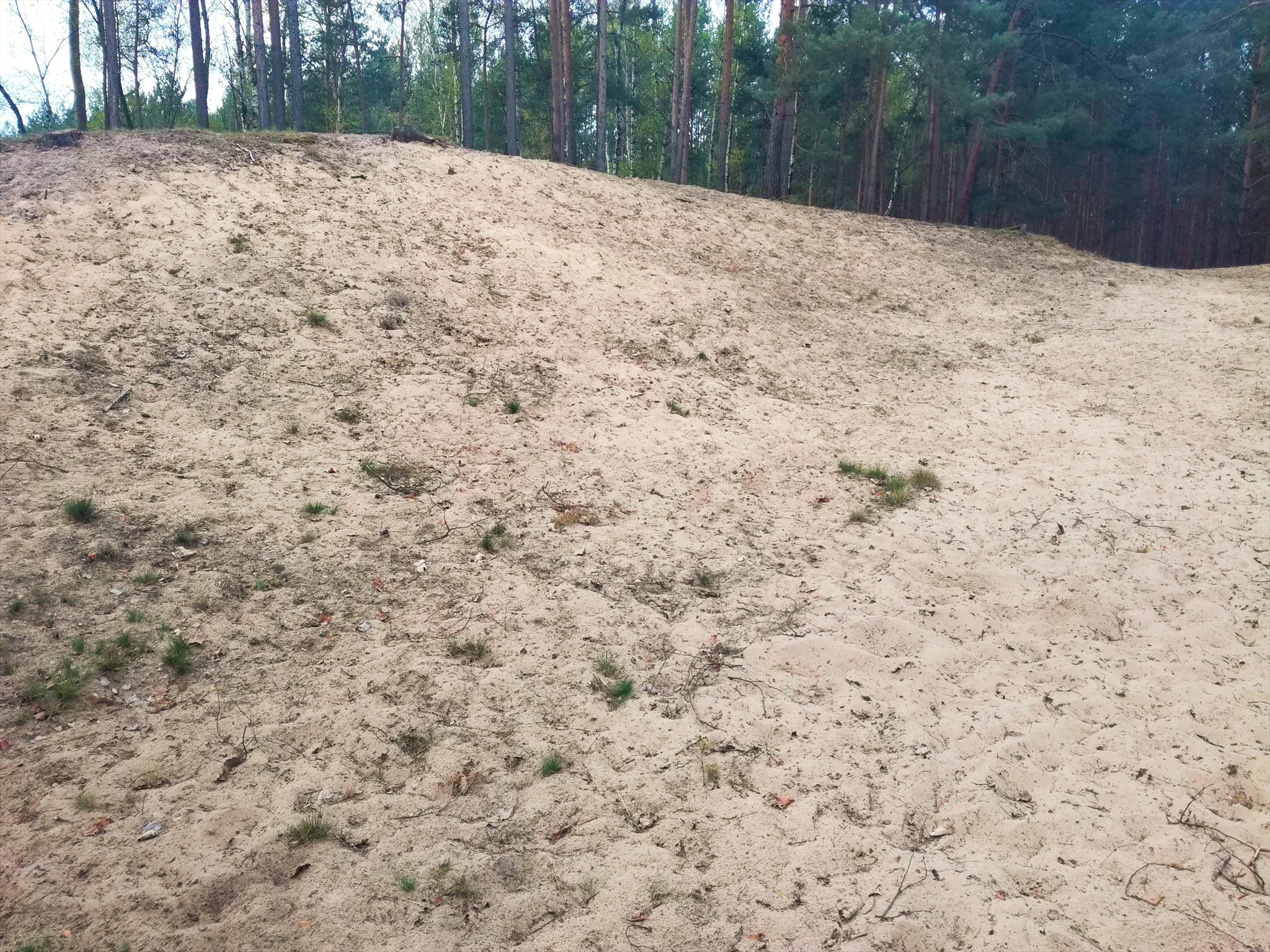
Písečný přesyp vznikl v době ledové cca 13000 – 11000 př.n.l. vyvátím materiálu ze štěrkopískových teras.
Tento přesyp pokrývá stejnověký lesní porost s borovice lesní. Z dalších dřevin se vyskytuje dub letní, bříza bělokorá a topol osika. Časté jsou i mechorosty a mykoflora. Po zoologické stránce je lokalita cenná zejména výskytem četných pískomilných druhů bezobratlých, jako jsou svižníci a mravkolvi.
K zabezpečení chráněného území před rušivými vlivy z okolí je stanoveno ochranné pásmo do vzdálenosti 50m od hranic přírodní památky. Území je označeno červeným pruhovým značením a tabulemi s malým státním znakem.
Vstup je povolen POUZE PO ZNAČENÝCH CESTÁCH.
/EN/
I invite you to visit an interesting place and at the same time to look back to a time long past.
The sand dump was formed during the Ice Age about 13000 - 11000 BC. by removing material from gravel-sand terraces.
This overburden covers a contemporaneous forest stand with Scots pine. Other woody species include summer oak, white birch and aspen poplar. Mosses and mycoflora are also common. From a zoological point of view, the locality is especially valuable for the occurrence of numerous gerbil-loving invertebrate species, such as snails and ants.
To protect the protected area from disturbing influences from the surroundings, a protection zone is established up to a distance of 50 m from the borders of the natural monument. The area is marked with red stripes and boards with a small state emblem.
Entry is ONLY ON MARKED ROADS.
Vznik teras
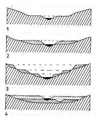
1 - skalní terasa, 2 - terasa vzniklá zaříznutím toku do říčních uloženin, 3 - tři terasové stupně vzniklé postupným zařezáváním toku (nejstarší terasa leží nejvýše, nejmladší nejníže), 4 - při dlouhodobém ukládání říčních nánosů (např. v klesajících oblastech) leží mladší terasa nad starší.
Termínem říční terasa v geologii rozumíme plochý, zarovnaný tvar zemského povrchu, který vznikl erozní a akumulační činností řeky.
Pro říční terasu je rozhodujícím znakem nadmořská výška její báze (tj. plochy kontaktu se skalním podložím), která má v ideálním případě charakter velmi mírně ukloněné roviny.
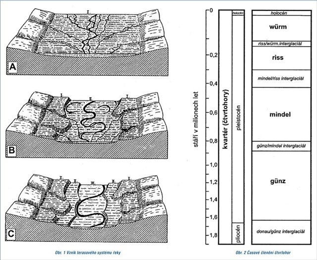
Každý větší tok má v rámci svého údolí vyvinutou soustavu teras. Jde o pruhy štěrkopísků přibližně deskovitého tvaru, které probíhají generelně rovnoběžně s tokem řeky (obr.1B). Nadmořská výška bází i povrchů jednotlivých teras stupňovitě klesá směrem k současnému toku. Štěrkopísky tedy nejsou v příčném řezu říčním údolím rozloženy spojitě, ale v podobě jakýchsi schodů, neboli teras (obr. 1C). Soustavu teras, ze které můžeme rekonstruovat průběh říčního toku v jednom nebo několika minulých obdobích, nazýváme terasovým systémem.
Klima ve čtvrtohorách
Vznik současné říční sítě a tvorba terasových systémů řek je jedním z hlavních znaků nejmladší geologické epochy – čtvrtohor (kvartéru), která začala před 2,5 mil. let. V předchozí geologické etapě – třetihorách (terciéru) řeky terasy nevytvářely.
Geologické procesy ve čtvrtohorách jsou odezvou výrazné změny klimatu na konci třetihor. Tehdy nastalo ochlazení s periodicky se opakujícími dobami ledovými, kdy docházelo k nebývalému rozšíření kontinentálního ledovce, a dobami meziledovými, kdy ledovec ustoupil, bylo teplo a poměrně vlhko. Na obr. 2 je znázorněno časové rozpětí a označení jednotlivých ledových a meziledových dob.
Vlastní doby ledové a meziledové byly obdobími klimatické stability. Také geologická činnost řek tehdy nebyla příliš výrazná. Probíhalo hlavně zvětrávaní hornin na místě. V teplém období převládalo zvětrávání chemické, v chladném období zvětrávání mechanické. Těžiště činnosti řek leželo v krátkých přechodných obdobích, kdy vegetace poskytovala malou ochranu před erozí a byl dostatek vody.
Vznik terasového systému
Při nástupu doby ledové (ochlazování) ustupovala vegetace, postupně převládla eroze a řeka vyhloubila do skalního podloží široké koryto (obr. 1A). Během doby ledové probíhalo intenzivní zvětrávání zemského povrchu, který byl vystaven mrazové destrukci, proti které nebyl chráněn téměř žádnou vegetací. Navíc bylo k dispozici velké množství klastických zvětralin a také nezpevněných ledovcových sedimentů, které může voda unášet.
Na konci doby ledové docházelo k tání ledovců a tím k uvolnění značného množství vody. Koryta řek byla zaplněna zvětralinami z doby ledové, které do nich přívaly vod spláchly (obr. 1A). Zvětrávání v chladném klimatu doby ledové spojené s poměrně dlouhým transportem způsobilo, že výplň koryt má nejčastěji charakter štěrkopísků.
Během teplé doby meziledové byl povrch kryt hojnou vegetací, takže erozní činnost řek byla značně omezena. Teprve během nástupu další doby ledové vegetační kryt značně zřídl, případně zmizel, a řeka se znovu zahloubila (obr. 1B). Nové, hlubší koryto však často už nebylo tak široké jako koryto předcházející. V okrajových částech předchozího koryta zůstala zachována část jeho výplně, která nebyla při vytvoření nového koryta odnesena (obr. 1A–1C). Tím vznikla terasa.
Popsaný cyklus se opakoval s každou ledovou dobou a tedy každá terasa představuje výplň říčního údolí z této ledové doby. Proto terasy označujeme názvy, odvozenými od názvů ledových dob (obr. 2). Sedimenty nejmladší terasy jsou často zachovány v podloží usazenin současné nivy (obr. 1C) – Niva Labe.
Tvorba terasového systému probíhá jinak v denudační oblasti a jinak v akumulační oblasti, kam patří i naše okolí. V denudační oblasti leží nejstarší terasy nejvýše nad současným tokem, zatímco v akumulačních oblastech leží nejstarší sedimenty na bázi souvrství a povrch pánevní výplně tvoří sedimenty nejmladší.
/EN/
1 - rock terrace, 2 - terrace created by cutting the stream into river deposits, 3 - three terrace steps created by gradual cutting of the stream (the oldest terrace lies highest, the youngest lowest), 4 - during long-term deposition of river deposits (eg in descending areas ) lies a younger terrace above the older one.
The term river terrace in geology means a flat, leveled shape of the earth's surface, which was created by the erosion and accumulation activity of the river.
The decisive feature for the river terrace is the altitude of its base (ie the area of contact with the bedrock), which ideally has the character of a very slightly inclined plane.
Each larger stream has a developed system of terraces within its valley. These are strips of gravel sand of approximately plate shape, which run generally parallel to the river flow (Fig. 1B). The altitude of the bases and surfaces of the individual terraces gradually decreases towards the current flow. Thus, the gravel sands are not distributed continuously in cross-section through the river valley, but in the form of some stairs, or terraces (Fig. 1C). The system of terraces, from which we can reconstruct the course of the river flow in one or several past periods, is called the terrace system.
Climate in the Quaternary
The emergence of the current river network and the creation of terrace systems of rivers is one of the main features of the youngest geological epoch - the Quaternary (Quaternary), which began 2.5 million years ago. In the previous geological stage - Tertiary (tertiary), the rivers did not create terraces.
Geological processes in the Quaternary are a response to significant climate change at the end of the Tertiary. At that time, there was a cooling with periodically recurring ice ages, when there was an unprecedented expansion of the continental glacier, and interglacial periods, when the glacier receded, it was warm and relatively humid. Fig. 2 shows the time span and the designation of the individual ice and interglacial periods.
The actual ice and interglacial periods were periods of climate stability. The geological activity of the rivers was not very significant at that time. The weather was mainly weathered on the spot. In the warm period, chemical weathering prevailed, in the cold period, mechanical weathering. The focus of river activities was in short transition periods, when vegetation provided little protection against erosion and there was enough water.
Origin of the terrace system
At the onset of the ice age (cooling), the vegetation receded, erosion gradually prevailed and the river dug a wide bed into the bedrock (Fig. 1A). During the ice age, there was an intense weathering of the earth's surface, which was exposed to frost destruction, against which it was not protected by almost any vegetation. In addition, there was a large amount of clastic weathering as well as unconsolidated glacial sediments that can be carried by the water.
At the end of the ice age, the glaciers melted and thus released a considerable amount of water. The riverbeds were filled with weather from the Ice Age, which washed away the inflows (Fig. 1A). Weathering in the cold climate of the ice age associated with a relatively long transport caused that the filling of the riverbeds most often has the character of gravel sands.
During the warm interglacial period, the surface was covered with abundant vegetation, so the erosion activity of the rivers was greatly reduced. It was only during the onset of the next ice age that the vegetation cover significantly thinned or disappeared, and the river deepened again (Fig. 1B). However, the new, deeper riverbed was often no longer as wide as the previous riverbed. In the marginal parts of the previous riverbed, a part of its filling was preserved, which was not carried away when the new riverbed was created (Fig. 1A – 1C). This created a terrace.
The described cycle was repeated with each ice age, and thus each terrace represents the filling of a river valley from this ice age. Therefore, we denote the terraces by names derived from the names of the ice ages (Fig. 2). The sediments of the youngest terrace are often preserved in the bedrock of the sediments of the current floodplain (Fig. 1C) - the Elbe floodplain.
The creation of the terrace system takes place differently in the denudation area and differently in the accumulation area, where our surroundings also belong. In the denudation area, the oldest terraces lie highest above the current stream, while in the accumulation areas the oldest sediments are located at the base of the formation and the surface of the pelvic filling is formed by the youngest sediments.
Pro uznání logu je nutné správně odpovědět na tyto otázky:
- Jak velký je písečný přesyp v ha?
- Od kterého roku je tento písečný přesyp chráněn jako přírodní památka?
- Přírodní památka Písečný přesyp u Osečka slouží k ochraně společenstev organismů částečně ...(čeho?). Stačí napsat tři následující slova, které zjistíte z infocedule na místě.
- Jaký jiný odborný výraz máme pro dobu ledovou?
- Kolik druhů mravkolvů zde žije?
- K logu připojte vaše foto (bez infocedule) z návštěvy tohoto místa.
Odpovědi na otázky zasílejte přes profil a pak se zalogujte, V případě nesrovnalostí vás kontaktuji.
/EN/
To recognize the log, you need to answer the following questions correctly:
- How big is the sand overflow in ha?
- From what year is this sand dune protected as a natural monument?
- The natural monument Písečný přesyp u Osečka serves to protect the communities of organisms in part ... (what?). Just type the following three words, which you'll find out from the info sign on the spot.
- What other technical term do we have for the Ice Age?
- How many species of ants live here?
- Attach your photo (without the info sign) from the visit to this place to the logo.
Send answers to questions via profile and then log in. In case of discrepancies, I will contact you.