English bellow.
O que aconteceu aqui?
Será que esse matacão caiu e achatou a terra criando essa deformação?
Olhe mais atentamente as "camadas" embaixo da pedra...hmmmm...não parece ser terra ou lama prensada, parece que são "fatias" ou camadas de rocha.
Agora olhe mais atentamente ainda para essas camadas inferiores, note a sua composição, a distribuição dos minerais, a cor e compare com a rocha em si....sim, isso mesmo, são muito parecidos...você talvez até arrisque a dizer que trata-se da mesma coisa.
Bom, eu posso afirmar para você que trata-se da mesma rocha, exatamente a mesma rocha, ou seja, essas camadas são pedaços deste pedrão que encontra-se bem em cima deles.
"Mas o que é esse negócio então?", você pode estar se perguntando. Calma, eu vou te explicar. Isso é um processo de intemperismo (desgaste e alteração devido à exposição ao clima) absolutamente natural que algumas rochas sofrem, principalmente os granitos.
Essa região de São Paulo é basicamente composta por granitos e esse matacão não é uma excessão. Olhe em volta e você verá várias rochas arredondadas, de fato por onde você andar nesse belo parque você verá rochas arredondadas por toda a parte. Todas são granitos vítimas do mesmo processo de intemperismo, a ESFOLIAÇÃO ESFEROIDAL.
Podemos descrever esse processo como sendo uma alteração intempérica (provocada pelas intempéries ou clima se preferir) desenvolvendo formas arredondadas concêntricas que se assemelham a cascas de cebolas, deixando, muitas vezes, blocos de rocha sã (boulders) perfeitamente arredondados no meio do solo ou da rocha parcialmente alterada.
A esfoliação esferoidal se dá em rochas maciças e relativamente isotrópicas (com a mesma propriedade em todas as direções) como os basaltos, granitos, gabros, grauvacas, etc que são inicialmente mais afetadas nos cantos de blocos fraturados, evoluindo em etapas de intemperismo progressivo no sub-solo para as formas arredondadas quando se formam as "camadas" de esfoliação variavelmente alteradas.
A erosão do solo nessas regiões com esfoliação esferoidal leva, frequentemente, a formação de espetaculares campos de boulders arredondados.

Essa imagem é de um grande maciço granítico sendo atacado pela esfoliação esferoidal em diversas fases. Vemos os blocos de trás ainda preservando algumas fáces angulosas e alguns boulders na parte da frente já destacados do maciço e completamente arredondados.
E porque esse cache se chama Cebolão? Porque, tal qual uma cebola, esse processo vai criando camadas concêntricas que se desprendem sucessivamente da rocha (veja a imagem abaixo).
Agora voltando ao nosso earthcache e a bela amostra de esfoliação esferoidal que temos em nossa frente eu faço algumas perguntas para você me responder via email ou mensagem para poder logar o find nesse earthcache. Não coloque as respostas e nem nenhuma foto reveladora no log mas fique a vontade para fazer uma bela selfie com você e seu grupo junto do matacão.
- Qual o tamanho aproximado em metros desta rocha (meça ao longo do caminho, por favor não existe nenhuma necessidade de subir no barranco) ?
- Qual é a cor predominante da rocha?
- Quantas camadas de rocha você consegue contar embaixo do matacão?
- Por fim, me explique o que são essas camadas ou fatias e o que as criou?
[ENGLISH VERSION]
What happened here?
Did this boulder fell and flatten the ground creating this deformation?
Look more closely at the "layers" under the stone ... hmmmm ... it does not look like dirt or pressed mud, it looks like they are "slices" or layers of rock.
Now look more closely at these lower layers, note their composition, the distribution of the minerals, the color and compare with the boulder itself .... yes, that's right, they are very similar ... you might even risk saying that it is the same thing.
Well, I can tell you that it is the same rock, exactly the same rock. These layers are pieces of this rock that lies right on top of them.
"But what is this thing?" You may be wondering. Calm down, I'll explain. This is a process of weathering (wear and tear due to exposure to the climate) that is quite natural for some rocks to suffer, especially granites.
This region of São Paulo is basically composed of granites, and this boulder is no exception. Look around and you will see several rounded rocks, in fact wherever you walk in this beautiful park you will see boulders all over. All granites are victims of the same process of weathering, SPHEROIDAL EXFOLIATION.
We can describe this process as being weather-altering (weather-provoked) by developing rounded concentric shapes that resemble onion shells, often leaving perfectly rounded boulders in the middle of the soil or rock partially altered.
The spheroidal exfoliation occurs in massive and relatively isotropic rocks (with the same property in all directions) as the basalts and granites among others that are initially more affected in the corners of fractured blocks, evolving in stages of progressive weathering in the sub-soil for rounded forms when variably altered "layers" of exfoliation form.
Soil erosion in these regions with spheroidal exfoliation often leads to the formation of spectacular fields of rounded boulders.
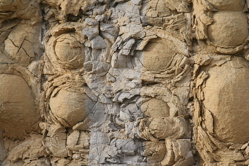
This image shows a rock suffering spheroidal exfoliation. We can see in 3D the layers and the boulders inside the layers. That's an awesome image.
And why is this cache called Big Onion? Because, like an onion, this process creates concentric layers that come off successively from the rock, as this image shows.
Now returning to our earthcache and the beautiful sample of spheroidal exfoliation that you have in front of you, I ask some questions for you to answer me via email or message to be able to log the find in this earthcache. Do not put the answers or any revealing pictures in the log but feel free to make a nice selfie with you and your group in front of the boulder.
- What is the approximate size in meters of this boulder? (measure along the way, please there is no need to climb the ravine)
- What is the predominant color of the boulder?
- How many layers of rock can you count under the boulder?
- Finally, explain to me what are these layers are and what created them?