L'heure solaire
L'heure solaire est définie directement par la position du Soleil à raison de 15° d'angle horaire par heure de temps. La Terre tourne autour de son axe en 24 heures, soit 360°/24 h = 15°/heure. L'heure solaire donne midi lorsqu'il passe exactement au Sud du lieu (méridien local).
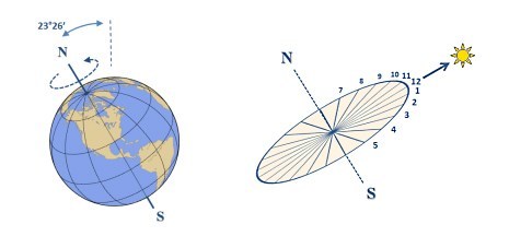
Ce temps dépend du point de vue de l'observateur, il est donc différent selon la longitude du lieu.
Sur un cadran solaire, la ligne de midi solaire correspond toujours au moment de la culmination du Soleil dans le ciel et son passage au méridien local. Elle est donc toujours dans le plan Nord-Sud et est toujours verticale sur un cadran vertical, quelque soit sa déclinaison.
Du gnomon au cadran solaire
Dans les sociétés primitives le moment de l’année était évalué grâce à un gnomon, une technique encore utilisée par des tribus amérindiennes ou indonésiennes. Il s’agit d’un simple piquet planté dans le sol et l’évaluation de la longueur de l’ombre portée du piquet permet de définir le moment de l’année par rapport au solstice d’été (ombre la plus courte) et au solstice d’hiver (ombre la plus longue).
L’origine du cadran solaire est babylonienne. C’est en effet ce peuple qui a introduit le cadran solaire en Egypte au IIème millénaire avant JC. L’introduction du cadran solaire en Grèce est le fait de l’astronome Anaximandre (vers 610-vers 547) qui l’aurait employé pour déterminer l’équinoxe. Le cadran solaire offre une évolution notable par rapport au gnomon, le plan et donc le temps est divisé en « parties égales ».
Certains cadrans solaires présentent plusieurs tracés qui tiennent compte de l’inégalité des saisons.
Il existe de nombreux types de cadrans solaires. En voici une liste non exhaustive :
- le cadran équatorial,
Le style fait un angle avec le plan horizontal égal à la latitude du lieu.Le tableau est perpendiculaire au style et fera donc avec le plan horizontal un angle de 90° moins la latitude du lieu.Les lignes horaires font des angles égaux de 15°. La ligne de 12h est sur le méridien local.Les lignes horaires sont tracées sur les deux faces de la table. La lecture s’effectue sur la face supérieure de l’équinoxe de printemps à l’équinoxe d’automne et sur la face inférieure de l’équinoxe d’automne à celui du printemps. Les cadrans équatoriaux qui ne présentent que la face supérieure ne seront lisibles qu’au printemps et en été.
- Le cadran polaire, qui ne donne l’heure que de 7H à 17H. La table du cadran est perpendiculaire au méridien de GREENWICH, c’est à dire à l’axe Nord/sud, et forme avec l’horizontale un angle égal à la latitude du lieu. Les lignes horaires sont parallèles.
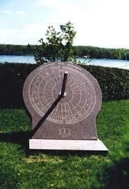
- Le cadran horizontal, se pose au sol ou sur un socle. La table du cadran est horizontale. Le style fait avec la table un angle égal à la latitude du lieu. Les lignes horaires sont la projection horizontale des lignes horaires du cadran équatorial.
- Le cadran hémisphérique, La table est un demi-cercle et fait avec l’horizontale un angle égal à la latitude du lieu. Les lignes horaires sont des projections sur la table du cadran équatorial, c’est à dire d’angles égaux de 15°. Le style est dans le plan du méridien local. Il fait avec l’horizontale un angle égal à la latitude du lieu. Sa hauteur correspond au rayon de la courbe de la table
- Les cadrans verticaux sont les plus communs, il en existe aussi différentes variétés.
· - les cadrans verticaux plein sud
· - les cadrans verticaux déclinants Est ou Ouest
· - les cadrans verticaux occidentaux ( tournés vers l’Ouest )
· - les cadrans verticaux orientaux ( tournés vers l’Est )
- certains cadrans dits « multiples » associent un cadran horizontal et un vertical ou un équatorial et un vertical
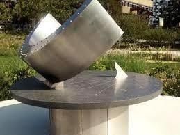
- Le cadran analemnatique. Il s’agit d’un cadran horizontal utilisant la représentation de la sphère terrestre sur une surface plane, et dont le style est vertical. Cette particularité permet de remplacer le style par un personnage. C’est un cadran qui devient une curiosité, un décor ou un jeu dans un lieu public.
L’importance du cadran solaire ne concerne pas que l’agriculture. Son utilisation pour calculer l’équinoxe a eu des conséquences très importantes pour l’avenir de l’astronomie et de la géographie. La détermination de l’équinoxe donne l’emplacement de l’équateur céleste et permet d’établir, par projection sur la Terre, la position de l’équateur terrestre. C’est grâce à ces calculs que l’on a pu évaluer la latitude.
Le cadran solaire a connu un énorme succès au temps de l’empire romain. Il était très en vogue également dans les pays musulmans. Il a été utilisé en Europe jusqu’au XVIIIe siècle.
Pendant des siècles, les cadrans solaires ont rythmé la vie quotidienne. Ils servaient également d’ornements sur les places des villages.
De l'heure solaire à l'heure de la montre
~ Correction de la longitude
L'Europe utilise partout le même fuseau horaire, le CET (Central European Time).
Les pays basés sur le fuseau CET s'étendent de la pointe occidentale de l'Espagne, avec Vigo, jusqu'à la frontière orientale de la Pologne, soit une étendue d'environ 2 heures de temps solaire.
Pour les lieux situés à l'Est du méridien CET, l'heure est décalée vers le matin (le Soleil se lève et se couche plus tôt). Pour les villes situées à l'Ouest, c'est le contraire, l'heure est décalée vers le soir, le Soleil se lève et se couche plus tard.
Un lieu en Europe doit donc calculer la correction de longitude par rapport au méridien de référence (ici 15° Est).
~ L'équation du temps
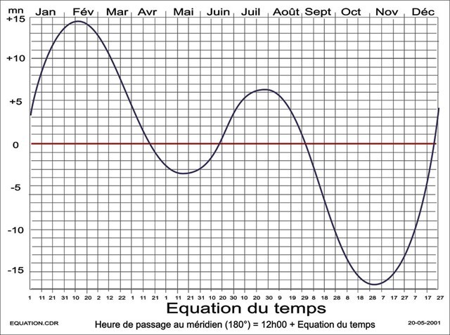
Elle témoigne de la variation annuelle de vitesse de rotation apparente du Soleil.
Elle provient d'une part de l'excentricité de l'orbite terrestre, et d'autre part de l'inclinaison de l'axe de rotation sur l'écliptique.
Cette variation atteint environ + ou - 16 minutes et s'annule 4 fois dans l'année et se matérialise sous la forme d'une courbe sinusoïdale.
~ Heure d'été / heure d'hiver
Il peut être nécessaire d'ajuster l'heure solaire en fonction de l'heure administrative (heure d'été/ heure d'hiver), si cette distinction existe dans le pays d'observation (comme c'est le cas en France).
Pour valider cette Earthcache, répondre aux questions suivantes en lisant le descriptif (1, 2 et 3), et sur place (4 et 5):
1. Résumez en quelques mots, le fonctionnement d’un gnomon ?
2. Comment appelle-t-on un cadran où vous ou quelqu’un d’autre sert de gnomon?
3. Quelle est la variation maximale de l’équation du temps par rapport à l’axe zéro ?
4. Au WP1, quel est selon vous le type de cadran que vous pouvez observer? (ne pas inclure de photo du cadran dans votre log ou celui-ci sera supprimé)
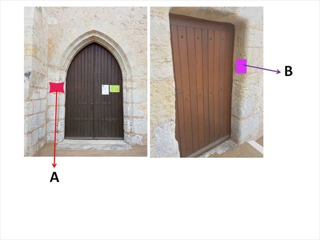
5. Au WP1, l'encadrement des portes de l'église est fait de tuffeau. Au niveau des deux photos ci-dessous, vous verrez 2 fossiles facilement reconnaissables sur la pierre A et sur la pierre B. D'après vous, de quoi s'agit il pour chaque fossile?
6. Une photo de votre montre devant l’église (mais sans montrer le cadran) serait appréciée mais n’est pas obligatoire.
Les « Earthcaches »: Il n'y a pas de conteneur à rechercher sur place. Il suffit de se rendre sur les lieux pour répondre aux questions ."Loguez cette cache "Found it" et envoyez-moi vos propositions de réponses soit via mon profil, soit via la messagerie geocaching.com (Message Center), et je vous contacterai en cas de problème."

Solar time
Solar time depends on the sun position in relation with the time needed by Earth to perform one rotation around its axis: as Earth performs a complete rotation in 24H therefore one hour corresponds to 360°/24h= 15°/hour. Therefore one solar hour equals 15°. Solar time gives noon time when sun is exactly above the south of the place where you are (local meridian). This solar time depends on where the observer is and is therefore different in each place of Earth.
On a sundial, the noon line is always the time when sun is at its highest in the sky at the precise point (local meridian). It is always on the north/south axis and is also vertical on a vertical sundial. This sort of time depends on the location, i.e. on its longitude.
From gnomon to sundial
In primitive societies, the time of year was evaluated using a gnomon, a technique that is still used by Amerindian or Indonesian tribes. It is made of a stake in the ground and the evaluation of the length of the cast shadow allow the definition of the time of year in relation with summer solstice (shortest shadow) and winter solstice (longest shadow).
Sundials originate from Babylonian society that introduced it in Egypt during the 2nd millennium BC. Its introduction in Greece was performed by an astronomer Anaximander (-610 - -547) who used it to determine equinox. Compared to gnomon, sundial main evolution is that time is divided in equal parts.
Some sundials have several profiles that take in account the variations of seasons.
Several types of sundials exist and here is a non-exhaustive list:
- equatorial sundial,
The pin has an angle with the horizontal plane equal to the latitude of the place. The table is orthogonal to the pin and will have a 90° minus the latitude of the place to the horizontal plane. Time lines have the same 15° space between them.
The line corresponding to noon is on the local meridian. Time lines are traced on both faces of the table. To read time, the top half of the table is used from spring equinox from fall equinox and the bottom half from fall equinox to spring equinox. If an equatorial sundial only shows the top half therefore it can only been used from spring to the end of summer.
- polar sundial, only gives time from 7 am to 5pm. The table of the sundial is orthogonal to Greenwich meridian i.e. to the North/South axis and has with the horizontal plane an angle equal to the latitude of the place. Time is represented by parallel lines.
- horizontal sundial, is commonly found on a pedestal or lies on the ground. The sundial table is horizontal. The pin forms with the table an angle equal to the laltitude of the place. Time lines are horizontal projections of time lines of an equatorial sundial.
- hemispherical sundial, the table is a semi-circle and makes with horizontal plane an angle equal to the place laltitude. Time lines are projections on the table of the equatorial sundial with equal angles of 15°. The pin is in the plane of the local meridian. It makes with the horizontal plane an angle equal to the latitude of the place. Its height corresponds to the radius of the curve of the table.
- vertical sundial, they are the most common and also exist in different subcategories :
· - South vertical sundial
· - East or West declining vertical sundial
· - Occidental vertical sundial (turned towards West direction)
· - Oriental vertical sundial (turned towards East direction)
- some sundials called as « multiple » result from the association between a horizontal plus a vertical sundial or an equatorial plus a vertical sundials.
- analemmatic sundial. Is made of a horizontal sundial using the representation of the earth sphere on a plane surface and having a vertical pin. In a classic analemmatic sundial, the style is perpendicular to the ellipse. The style must be placed on the date line at the position corresponding to the current date. The shadow of the style is extended to the ellipse where points mark hours.
Analemmatic sundials are usually installed in parks where the large ellipse is drawn on the ground. A person then stands on the date line with the hand raised above him to cast a shadow on the ellipse.
.
Sundials were not only important for agriculture but also its use for equinox calculation was a starting point in astronomy and geography. Determination of equinox provided data for locating celestial equator with then allowed determining the earth equator. These mathematical studies then allowed calculation of latitude.
Sundials were very popular in Roman empire and in Muslim countries. They were in use in Europe until the 18th century.
Sundials were providing a rhythm for daily activities and were also ornaments on the main square of villages.
From solar time to your watch
~ Longitudinal correction
Europe uses the same time fuse i.e. CET (Central European Time). Countries using the CET spread from the occidental extremity of Spain (Vigo) to the oriental limit of Poland, meaning that there is a variation of 2h of solar time between these two points. For places located East of CET meridian, sun rises earlier in the morning (there is a time shift towards morning). For places located West of CET, it’s the reverse situation, with sunrise and sunset being later in the day.
There is therefore a longitudinal correction to apply to solar time in relation with the meridian of reference. (here 15° East).
~ Time equation
It reflects the annual variation of the speed of rotation of the sun. It comes from the out-of-center of Earth’s orbit and from the inclination of the rotation axis on an ellipse. This variation reaches + or – 16 minutes and is null four times a year. This variation is represented as a sinusoid curve.
~ Summer time / winter time
It could be necessary to adjust the solar time to fit the administrative time (summer time/ winter time) if this distinction exists in the country of observation (as is the case in France).
To validate this Earthcache, please answer the following questions by reading the cache description (1, 2 and 3) and on site (4 and 5):
1) Summarize in a few words, how a gnomon works
2) How do you qualify a sundial in which you are the gnomon?
3) What is the maximal time variation (in minutes) in the time equation?
4) At WP1, what type of sundial can you see? (please do not post pictures)
5) At WP1, the frames of the two gates of the church are made of chalkstone. At the level of the pictures, you will see 2 easily recognizable fossils on stone A and on stone B. How would you name each fossil? (please do not post pictures)
6) A picture of your watch in front of the church (not showing the sundial) would be appreciated but it is not compulsory.
“Earthcache” are not associated with a box on site. You just need to go there to answer the questions. Log the cache “Found it” and send me your replies either through my profile or using Geocaching.com message center. I will contact you in case of problem.