Bonjour,
Le plateau de l’Estabel dénote au sein des paysages régionaux autant par sa planéité que par la hauteur du talus qui l’interrompt à l’Est, en rive droite de la Boyne.
L’étrange source de l’Estabel
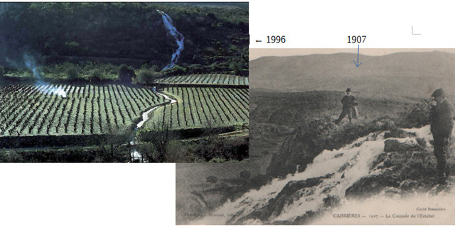
Cette source, située à 175 m d’altitude, n’a jailli que 11 fois depuis 1856. C’est souvent avec violence ( entre 300 et 800 l/s) et toujours lors de plus soutenues, répétées, responsables d’inondations régionales.
Son nom porte en lui-même ce caractère mystérieux : l'Estabel se rapporterait tantôt à une variante occitane signifiant « tourbillon », une allusion à l'eau qui jaillit à 25°C en tourbillonnant, et ce, plusieurs fois par siècle ; tantôt l'origine s'entendrait par le terme « Estambel », le « bel étang », hypothèse parfois citée mais qui ne semble pas mieux établie.
Quoi qu'il en soit, le nom renverrait à l'état marécageux du plateau avant que les vignerons n'aient entrepris le creusement du canal de drainage qui relie aujourd'hui la source et la cascade.
Cette originalité découle de la complexité géologique locale.
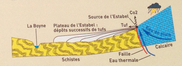
Sa température ( 22° à 24°), plus élevée de 10° par rapport à celle des sources voisines, révèle que l’eau provient, en partie, de plus de 300m de profondeur, c’est-à-dire d’au moins 125 m en dessous du niveau de la mer.
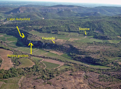
La source jaillit à proximité d’une fracture Nord-ouest / Sud-est injectée de quartz, visible sur plus d’un kilomètre de longueur. Le panneau calcaire, d’où jaillit la source, en contact direct avec les schistes ordoviciens, est invisible en surface, masqué par les éboulis et les tufs. Il abrite une grotte, d’où sort l’eau en crue .

Cette eau est riche en gaz carbonique et en calcium. Dès la source, le dégagement dans l’air du gaz carbonique entraîne immédiatement le dépôt des calcaires, sous forme de tufs.
Entre la source et la confluence avec la Boyne, dégazage et dépôts de tufs se poursuivent grâce à l’action combinée des algues, des mousses et des irrégularités rocheuses.
Sources : les panneaux (les crêtes de Vissou ) +http://www.cabrieres-en-languedoc.com/fr/sentier-des-cretes-du-vissou/les-mysteres-de-lestabel + http://www.ccclermontais.fr/IMG/pdf/Livret_du_Clermontais_3-l_Estabel_bd.pdf
Loguez cette cache "Found it" et envoyez-moi vos propositions de réponses aux questions suivantes, soit via mon profil, soit via la messagerie geocaching.com (Message Center), et je vous contacterai en cas de problème.
Questions :
1) Hauteur de la falaise d’Estabel ?
2) Roche qui compose cette falaise ?
3) Peut-on apercevoir l’abri Rotschild ou des petites grottes (avec des jumelles) dans la paroi depuis le PZ ?
4) Particularité de l’eau qui jaillit ?
5) Origine des tufs ?
6) A chaque crue de l’Estabel, une importante quantité de calcaire se dépose sur les troncs d’arbres, les branches, les feuillages… En 1996, lors de la dernière crue quels objets ( exposé à la cave coopérative) ont été recouverts de quelques centimètres de calcaires ?
English :
Hello,

The plateau of the Estabel denotes within the regional landscapes as much by its flatness as by the height of the embankment which interrupts it to the East, on the right bank of the Boyne.

The strange source of Estabel

This source, located 175 m above sea level, has sprouted only 11 times since 1856. It is often with violence (between 300 and 800 l / s) and always during more sustained, repeated, responsible for regional floods .

Its name carries within itself this mysterious character: the Estabel would refer sometimes to an Occitan variant meaning "whirlwind", an allusion to the water that gushes out at 25 ° C by swirling, and this, several times a century; sometimes the origin would be understood by the term "Estambel", the "beautiful pond", hypothesis sometimes quoted but which does not seem better established.
Anyway, the name would return to the marshy state of the plateau before the vine growers have undertaken the digging of the drainage channel that now connects the source and the waterfall.

This originality stems from the local geological complexity.
Its temperature (22 ° to 24 °), 10 ° higher than that of neighboring sources, reveals that the water comes, in part, more than 300m deep, that is to say from less 125 m below sea level.

The spring gushes near a northwest-southeast fracture injected with quartz, visible for more than one kilometer in length. The limestone panel, from which springs the spring, in direct contact with the Ordovician schists, is invisible on the surface, masked by scree and tuffs. It shelters a cave, from which the water comes out in flood.

This water is rich in carbon dioxide and calcium. From the source, the release of carbon dioxide in the air immediately causes the deposit of limestones, in the form of tuffs.
Between the source and the confluence with the Boyne, degassing and tufa deposits continue through the combined action of algae, mosses and rocky irregularities.
Log this cache "Found it" and send me your suggestions for answers to the following questions, either via my profile or via geocaching.com (Message Center), and I will contact you in case of problems.

Questions :

1) Height of the Estabel cliff ?
2) Rock that makes up this cliff ?
3) Can we see the Rotschild shelter or small caves (with binoculars) in the wall from the PZ?
4) Particularity of the water that gushes?
5) Origin of the tuffs?
6) With each flood of the Estabel, a large quantity of limestone is deposited on the trunks of the trees, the branches, the foliage ... In 1996, during the last flood which objects (exposed with the cellar cooperative) were covered a few centimeters of limestone?