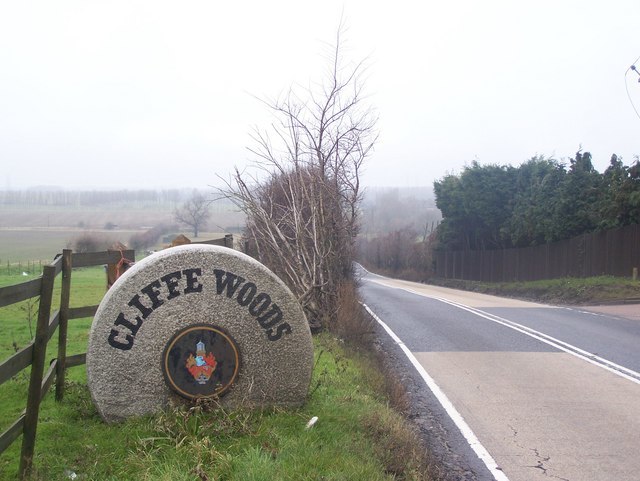
VS#1441 Cliffe Woods Mystery Cache
-
Difficulty:
-

-
Terrain:
-

Size:  (micro)
Please note Use of geocaching.com services is subject to the terms and conditions
in our disclaimer.
THE CACHE IS NOT AT THE PUBLISHED COORDANATES.
Cliffe Woods is a small suburb on the Hoo Peninsula in the unitary authority of Medway in South East England. It was, until 1998,[1] part of Kent and is still ceremonially associated via the Lieutenancies Act.[2] It forms part of the parish of Cliffe and Cliffe Woods. It was once just a hamlet and is situated next to Higham. The old woods rise to meet Chattenden and the Ratcliffe highway Cliffe Woods is a village that has been built in an ancient area of woodland. Its roots are closely tied to the surrounding area which stretch back to pre-Roman times. At the time of the Norman conquest of England Cliffe Woods was part of the Hundred of Shamwell. Of the adjacent listed Domesday Book settlements, Cooling, Oakleigh and Haven, only Cooling had any recorded woodland resources in its inventory.[3] The woods were used for the pannage of pigs; ten pigs a year were paid to Wulfwin the local Anglo Saxon Lord. His Germanic name means wolf-friend. The Anglo Saxon overlord was Leofwine Godwinson who was the brother of King Harold. According to Edward Hasted (1732-1812), the father of Kent history, ‘Southward of the common field, on the road to Rochester, the land rises to the hilly country, a poor clayey soil likewise, where is the manor of Mortimer’s, at the southern boundary of this parish. The manor was in the possession of the great family of Mortimer, Hugh de Mortimer was in possession of the manor in the reign of Edward I of England' (1239-1307).[4] The naming of Mortimer’s Wood and subsequently Mortimer’s Avenue can be associated from its connection to the old manor. Some other road names in the eastern part of Cliffe Woods are also historically connected to the manor. For example, Englefield Crescent is named after Thomas Englefield (1455-1514) the Speaker of the House of Commons in the reign of Henry VII of England; he also owned Mortimer's.[5] Burye-Court Manor (associated with Berry Court Wood) was granted to George Brooke, 9th Baron Cobham in 1541 by Henry VIII of England. His grandson Henry Brooke, 11th Baron Cobham lost the manor in 1603 after being convicted of treason against James VI and I, which resulted in his imprisonment in the Tower of London.
About Village Sign Caches This cache belongs to the Village Sign Series, a series of caches based on ornate signs that depict the heritage, history and culture of the villages that put them up (generally on the village green!). The signs can be made of different materials from fibreglass to wood, from forged steel to stone. They can depict anything from local industry to historical events. The tradition probably started in Norfolk or Suffolk and has now spread across most of the country so we thought we would base a series on them! More information and statistics can be found at the Village Signs Website - https://www.villagesignseries.co.uk
Additional Hints
(Decrypt)
[puzzle] guvf yvfgvat ubyqf nyy gur vasbezngvba lbh arrq. [Geocache] ybbx ybj.