Introduction: This Earthcache will take you to two locations:
At the posted coordinates you will find a rock outcrop with distinct geology
At the “structure” waypoint, is located a man-made object incorporating rocks from the area.
Both locations must be visited.
To log this Earthcache: Read the geology lesson below. Visit both sites. Answer all the questions posed at the end of the cache description. Answers can be sent via e-mail or messenger contacts on my Geocaching profile.
Do not post the answers to the questions in your logs. Do not post spoiler pictures from either site.
Logs will be deleted if answers are not sent or spoiler pictures are included.
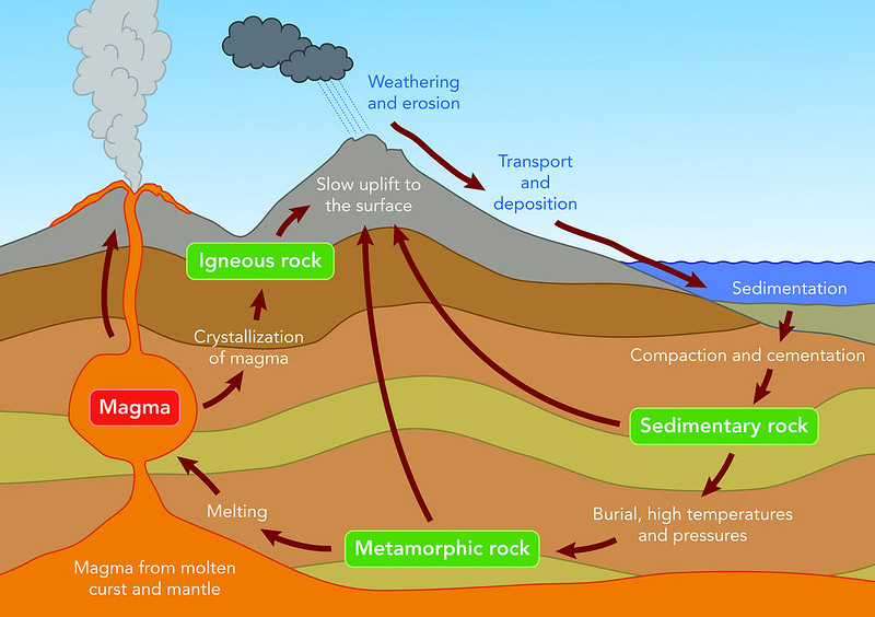
The Rock Cycle: Rocks are in a constant state of transformation. The three main types of rocks (Sedimentary, Metamorphic and Igneous) are all building blocks for each other. This cache will capture one small transition from Sedimentary to Metamorphic rocks through a process known on Barrovian Metamorphism.
The interplay and transformation of rocks into one another is referred to as the “rock cycle” which is pictured below.[1] In the picture the three rock types (listed in green boxes) can be seen eventually being pushed to the Earth’s surface where they undergo the process of weathering and erosion. The net result of weathering and erosion is breaking down of rocks into their simpler constituent parts.
The weathering through sedimentation processes are depicted above in the rock cycle (located in the upper right quadrant of the picture). A further breakdown of this process chain is provided in the diagram below. This diagram shows the evolution of sedimentary rocks.[2] When weathering of rocks is combined with “transportation” and “deposition” it leads to three final end products; quartz/sandstone, shale (clay), and limestone (CaCO3). During this process rocks break down and change chemically. Only quartz (sand or silicate) remains unchanged. Other rocks chemically dissolve to make the sea salty, or decompose to form new minerals stable at the earth's surface.
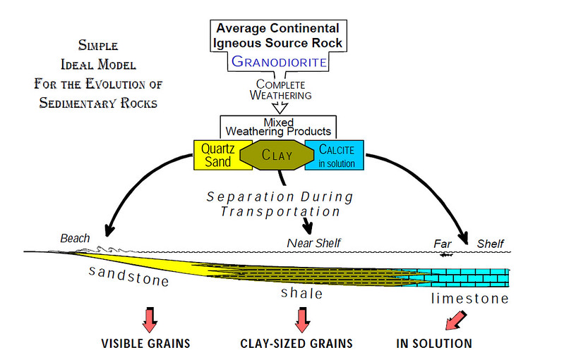
The minerals formed through weathering and chemical change undergo sorting during transportation. The sand and clay, beginning as a poorly sorted mixture, are separated more and more as they travel down-stream away from their source. Quartz sand is the heavier of the two and slowly gets dragged by water currents, causing it to lag behind. Clay, which is transported in a suspension in the water, travels much easier. Finally, the CaCO3 present is actually dissolved and therefore just travels in the moving water.
During transportation these three weathering products do not transport equally well, and become separated. The final separation takes place at the ocean shoreline. Waves crashing on the beach keep the sediment continuously stirred up. The quartz, being relatively heavy, settles quickly to the bottom nearest to the shore (where it serves as the basis for sandstone). Clay remains in suspension until it drifts to the near shelf where wave action abates. Here if finally settles to the bottom to form shale. Finally, the dissolved CaCO3 precipitates out of suspension in the far shelf, beyond the range of sand and clay, to form limestone.
This Earthcache will look at the fate of the clay/shale portion of the Sedimentary Rock Evolution.
The Culpeper Basin: With the ocean many miles away, the question arises of how shale came to be located along the Occoquan river and Bull Run where this Earthcache is located.
Hundreds of millions of years ago Virginia was located in the middle of the supercontinent of Pangea (which was created by the collision of the North American and African plates). The location of VA can be seen in the area circled in Red in the picture below.[3]
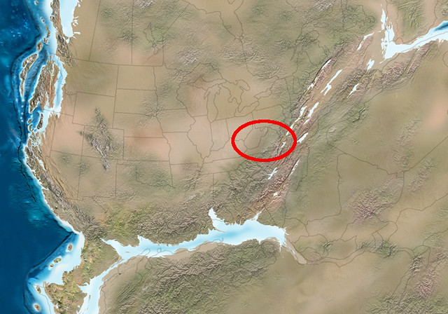
As Pangea split up, the crust at the interface thinned and cracked. Large basins were created which filled with water and with sediment. The picture below shows one of the basins formed during this process. The Culpeper Basin is seen in blue/red and labeled as being a “Triassic Basin”.[3] This massive basin would allow the same separation of sedimentary rocks which created the shale on the ocean floor discussed earlier. To the east of the Triassic Basin resides the Piedmont (in purple on the diagram). These rocks existed before the sediments formed in the Triassic Basin, and are older.

Bull Run resides just on the eastern border of the Culpeper Basin. The rough location of the rock outcrop at the Earthcache’s main coordinates is marked with a black “X” on the map below. The map depicts a section of the Culpeper Basin (colored red for Sandstone and beige for Siltstone.[4] Rocks in these areas and are defined as the Manassas Sandstone, the Balls Bluff Siltstone, and the Bull Run Formation.[5] The Manassas Sandstone and the Bull Run Formation consist chiefly of fan-shaped deposits of conglomerate, sandstone, siltstone, and shale.
Bull Run shales represent the youngest of the three Triassic formations in Virginia.[6] There are several varieties of Bull Run shale. The red variety is by far the most important and probably forms about 80% of all the Triassic shales. For these red shales, the coloring agent is FERRIC OXIDE (just like in rust) which permeates the rock. Remember the rocks of the outcrop marked by the X are OLDER than the Bull Run shale.

Barrovian Metamorphism: So far the discussion has focused on rocks being broken down into their simpler elements and separating to form the basis of the next generation of sedimentary rocks. The rock outcrop at the listed coordinates shows the result of the metamorphosis of the clay component mentioned earlier.
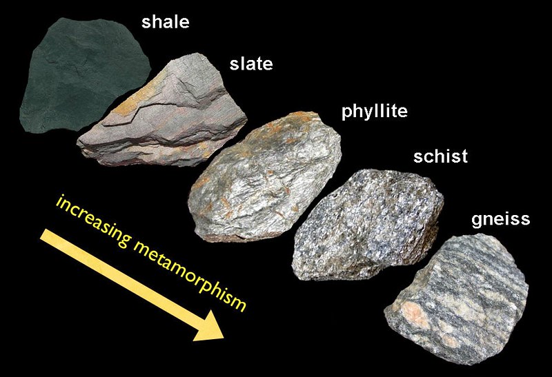
Barrovian metamorphism is the most commonly encountered metamorphism. It takes place during mountain building events when very large areas of sedimentary rocks are buried, squeezed, and heated. Such conditions existed when Pangea was created. Barrovian metamorphism is widely found on all parts of the earth, and produces the most common metamorphic rocks. The figure below shows its effect on clay deposits.[7]
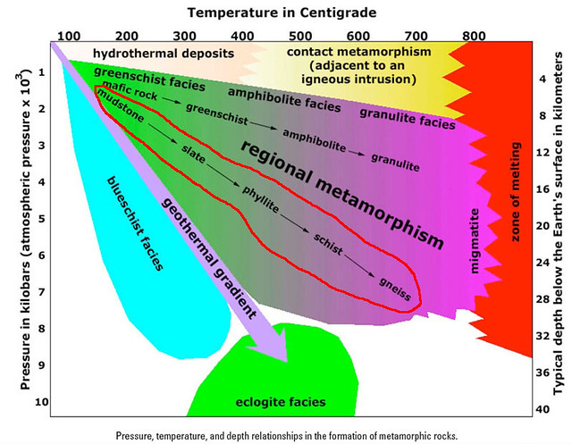
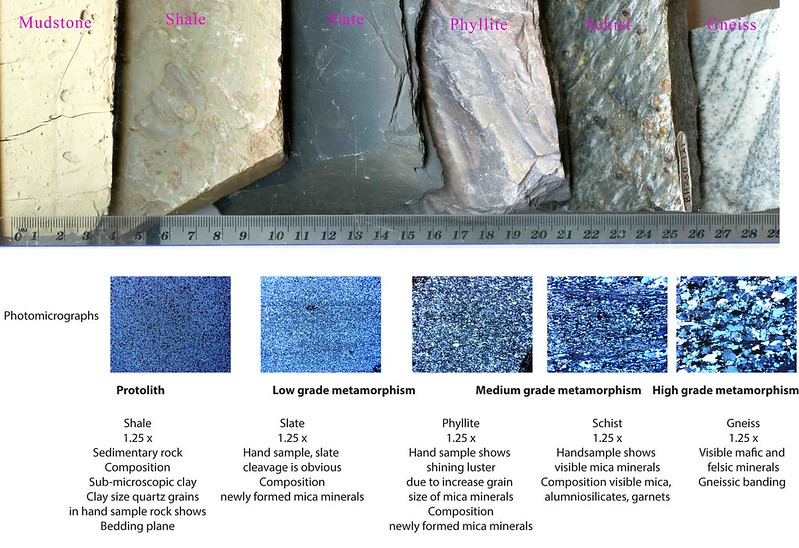
Circled in red is the series of rocks created from clay. Going from left to right on the chart represents an increase in temperature. Going from top to bottom corresponds with an increase in pressure. The clay settling on bottom of an ocean or lake bed eventually gets buried, and under pressure forms mudstone. As geological forces push this layer deeper below the surface of the earth both temperature and pressure increase. This turns the mudstone to slate, slate to phyllite, phyllite to schist and, finally, schist to gneiss. For purposes of this discussion, shale can be assumed to be similar to the mudstone listed in the diagram above.
Simple sedimentary rocks, such as quartz sandstone and limestone (calcite) do not change composition with metamorphism - their chemistry is too simple. Clay is different. As the clay goes through this metamorphosis the chemistry of the rock changes, as does it appearance. The picture below shows the distinct difference in outward appearance of rocks as they transition from shale to gneiss.[7] As can be seen, the rocks start to take on more of a lustrous appearance and eventually develop unique striations.
As they become buried, and exposed to extreme pressure and heat, the sedimentary minerals in clay become unstable and transform into new metamorphic minerals. Clay goes to chlorite, and chlorite eventually goes to quartz, feldspar, and mica, as well as other minerals.(8)
The sheen developed in the middle stages of the metamorphosis can be attributed to the presence of mica being formed during the process. The image below provides a perspective of the chemical changes associated with mica formation.[9]
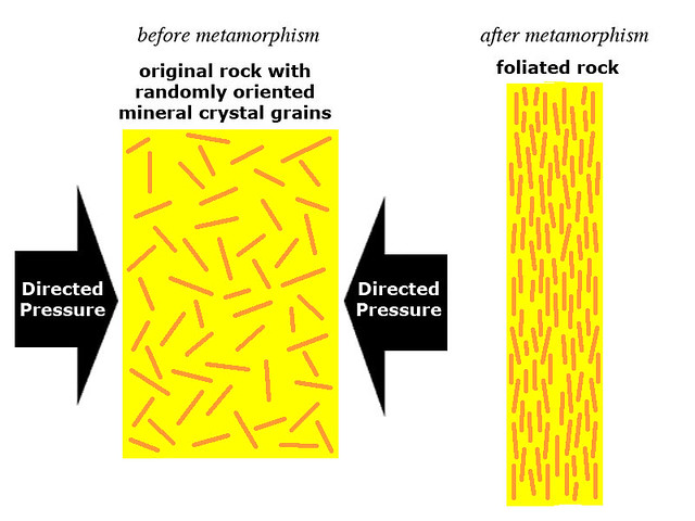
However, micas are not just being formed during the process. The grains they form are becoming aligned. The process they undergo is called foliation. Foliation occurs when mineral grains orient themselves in such a way that they create repetitive planar structures. It is caused by forces that are significantly higher in one direction than the others. The image below illustrates this process.[7] Chemical processes account for the color change of the rock, however, the increased orientation of mica grains account for the increased luster. Phyllite owes its greater silky sheen than slate to microscopic crystals of white mica, called sericite, which is used in cosmetics for a similar effect.
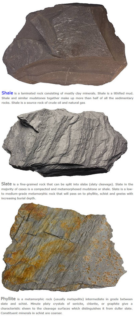
This alignment of mineral grains also causes the rock to cleave in flat planes. This is why slate cleaves into large flat sheets ideal for roofing tiles (and in the old days blackboards). This physical attribute is actually referred to as “Slaty Cleavage”.
The Earthcache: As mentioned earlier the outcrop of rock at the Earthcache coordinates come from a zone known to be older than the adjacent Culpeper Basin. To claim credit for the cache answer the following six (6) questions:
Question 1. With the stream to your back what metamorphic rock found between mudstone and gneiss makes up the right hand side of the outcrop? The picture below might help.
Question 2. What observable physical properties made you chose the rock in your answer to question 1?
Question 3. Right in front of the outcrop is a mid-size boulder. What signs does this boulder, or the outcrop, show of once sharing chemical characteristics in common with the red shales that exist to the west of this region? (Hint: What made red shales red?)
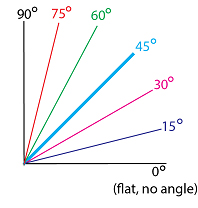
Question 4. Looking at the Slaty Cleavage present in both boulder and outcrop, what angle are the cleavage lines running? See angles below to help.
Question 5. At the “structure” waypoint upstream, what use has been made of the rock?
Question 6. What is the thickness range for pieces of rock exposed at this waypoint?
REFERENCES
1. https://www.zmescience.com/other/feature-post/rock-cycle-geoloby-abc/
2. http://csmgeo.csm.jmu.edu/geollab/Fichter/SedRx/SimpModl.html#simpleidealmodel
3. http://www.virginiaplaces.org/geology/triassic.html
4. Geomap: B.D. Leavy, A.J. Froelich and E.C. Abram, “Bedrock Map and Geotechnical Properties of Rocks of the Culpeper Basin and Vicinity, Virginia and Maryland”, U.S. Geological Survey, 1983. https://pubs.usgs.gov/imap/1313c/plate-1.pdf
5. K.Y. Lee, “Triassic Stratigraphy in the Northern Part of the Culpeper Basin, Virginia and Maryland”, Geological Survey Bulletin 1422-C, U.S. Dept. of the Interior, 1977. https://pubs.usgs.gov/bul/1422c/report.pdf
6. J.K. Roberts, “The Geology of the Virginia Triassic”, Virginia Geological Survey, Bulletin 29, 1928. https://www.dmme.virginia.gov/commercedocs/BUL_29.pdf
7. http://geologycafe.com/class/chapter10.html
8. http://csmgeo.csm.jmu.edu/geollab/Fichter/MetaRx/metasimple.html 9.http://www.people.carleton.edu/~bhaileab/IntroductionToGeology/IntroToGelogyRocks/FromMudToGneiss.jpg


CONGRATS TO rlobecker