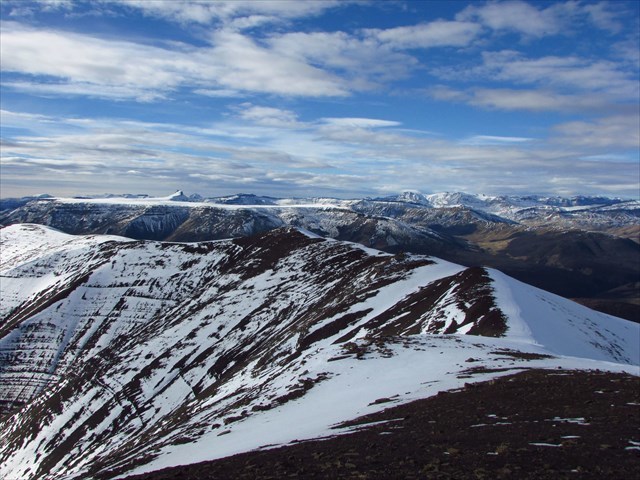
(ES) El Cerro Cristal (1.282 msnm) se encuentra en el Parque Nacional Los Glaciares y desde la cima uno se siente un poco Dios y un poco nada. Desde la cumbre hay una vista panorámica de lagos, glaciares y picos de los Andes.
(EN) Cerro Cristal (1.282 m) is located in Los Glaciares National Park and from the top one feels a little bit like God and on the other hand like nothing. From the summit there is a circular view of lakes, glaciers and peaks of the Andes.
(CZ) Cerro Cristal (1 282 m.n.m) se nachází v národním parku Los Glaciares, z jehož vrcholku se jeden cítí trošku jako bůh a trošku jako nic. Z vrcholového místa se otevírá výhled na jezera, ledovce a vrcholky And.
El cinturón de la Cordillera de los Andes se extiende a lo largo de América del Sur y recorre los territoros de Venezuela, Colombia, Ecuador, Perú, Bolívia, Argentina y Chile. Tiene casi 8 000 km de longitud y hasta 500 km de ancho. Su altura media es de 4 000 msnm. El pico más alto es Aconcagua (6 959 msnm) y se encuentra en Argentina. Los Andes se dividen en tres partes: norteña, central y austral, y se consta de dos crestas a lo largo de la longitud: Cordillera Occidental y Cordillera Oriental. Además, en Colombia se dividen en tres crestas paralelas. En Patagonia hay varias partes glaciares como por ejemplo el Campo de hielo patagónico norte, El Campo de hielo Patagónico Sur y el glaciar en la Cordillera Darwin.
El cinturón montañoso empezó a formarse durante el período Cretácico hace 138 hasta 65 millones de años. La causa de elevación y plegamiento de las rocas sedimentarias era la subducción de placa Pacífica por debajo de la placa Sudamericana. Más específicamente se formó por la subducción de las plácas de Nazca y la Antártica. En casi toda la longitud de la cordillera hay fallas tectónicas las cuales son causa de terremotos y de actividad volcánica hasta hoy. Las partes glaciares tienen su orígen en la era cuaternaria. El glaciar más famoso se llama Perito Moreno, se encuentra en el Parque Nacional de los Glaciares y se puede observar desde la cima de Cerro Cristal.
Gran parte de los macizos en los Andes peruanos y patagónicos corresponden a batolitos de tonalita, granito, diorita y granodiorita. Estas rocas corresponden a la actividad volcánica y se descubrieron por una combinación de alzamiento tectónico y erosión.
El nombre de la cordillera es también interesante y tiene varias explicaciones. El probable orígen sería el término quechua anti que significa 'cresta elevada' o del término quechua Antisuyo, uno de las regiones del Imperio inca. Otra explicación proviene del término aimara anta, 'color de cobre', y de la palabra quechua anta que significa 'cobre'. El nombre fue usado por primera vez por el cronista hispanoperuano Inca Garcilaso de la Vega y se refería a aquella zona de los Andes que está cerca de Cuzco, donde hay vetas y depósitos metalíferos y los óxidos de los elementos metálicos mantienen un color cobrizo.
Para registrar el caché es necesario responder las preguntas siguientes:
1) ¿Cuándo y cómo se formó la Cordillera de los Andes?
2) Echá un vistazo de cerca a las rocas solitarias cerca del sendero. Descríbilos (su color, tipo de roca, etc.). ¿Cómo crees que fueron creados?
3) Mirá alrededor. ¿Qué roca forma el sustrato de la cima de Cerro Cristal?
4) Sacá una foto en la cumbre.

The high mountains belt of the Andes extends across South America and it is situated in the territory of Venezuela, Colombia, Ecuador, Peru, Bolivia, Chile and Argentina. The Andes are almost 8,000 km long and up to 500 km wide. Their average height is around 4,000 m and the highest peak of Argentina's Aconcagua has 6 959 m. The Andean Mountains are divided into the north, central and southern part. Across the length the range is formed by two ridges – the Western Cordillera and the Oriental Cordillera. In Colombia, it is even divided into three parallel ridges. In Patagonia there are a few glacial parts, like for example the Northern Patagonian Ice Field, the Southern Patagonian Ice Field and the glacier of the Cordillera Darwin.
The mountain belt began to form during the Cretaceous period from 138 million to 65 million years ago. The cause of the uplift and the sediments folding was a slow sliding of the Pacific Plate under the South American Plate. Specifically, it was caused by subduction of the Nazca and the Antarctic Plate. Along the whole range there are obvious tectonic faults which are still causing earthquakes and volcanic activity.The glacier parts were created during the Quarternary period. The most famous glacier is the Perito Moreno Glacier, in Los Glaciares National Park, which you can admire from the summit of Cerro Cristal.
A large part of massives of the Patagonian and the Peruvian Andes is made up of batholiths of tonalite, granite, diorite and granodiorite. These rocks are related to volcanic activity and they were revealed through a combination of tectonic uplift and erosion.
The name of the mountain range is also interesting and it has several explanations. It could have origin in the Quechuan word anti which means a high ridge or it originated from the Quechuan word Antisuyo, which was the name of one of the Inca Empire regions. Another explanation is from the Aymara word anta, copper color, and the Quechuan denomination for copper, anta. For the first time, the name was used by the chronicler Inca Garcilaso de la Vega for the Andean area of Cuzco, where the ore veins, metallic sediments and metal oxides, which have a copper color.
To log this cache you must respond to the following questions:
1) When and how the Andes were created?
2) Take a close look at lonely boulders near the trail. Describe them (their color, type of rock, etc.). How do you think they were created?
3) Look around. Which rock forms the bedrock of the summit of Cerro Cristal?
4) Take a photo on the top.


Velehorský pás And se táhne přes celou Jižní Ameriku a zasahuje na území Venezuely, Kolumbie, Ekvádoru, Peru, Bolívie, Chile a Argentiny. Jsou téměř 8 000 km dlouhé a až 500 km široké. Jejich průměrná výška se pohybuje okolo 4 000 m.n.m., přičemž nejvyšším vrcholem je argentinská Aconcagua, která měří 6959 m. n.m. Andy se dělí na severní, centrální a jižní část a po celé délce je tvoří dva hřbety - Cordillera Occidental a Cordillera Oriental. V Kolumbii se dokonce dělí na tři paralelní hřbety. V patagonské části se nalézá několik zaledněných částí, mezi které patří severopatagonské ledovcové pole, jihopatagonské ledovcové pole a ledovec v Darwinově pohoří.
Horský pás se začal formovat v období křídy před 138 milióny až 65 milióny lety. Příčinou zdvihu a vrásnění usazených hornin bylo pomalé nasouvání tichomořské kry pod jihoamerickou pevninskou kru. Přesněji docházelo k subdukci desky Nazca a Antarktické desky. Téměř po celé délce pohoří jsou patrné tektonické poruchy, které jsou dodnes příčinou zemětřesení a vulkanické činnosti. Zaledněné plochy vznikly v období čtvrtohor. Nejznámějším ledovcem je ledovec Perito Moreno, v národním parku Los Glaciares, který lze obdivovat z vrcholu Cerro Cristal.
Velká část masivů v patagonských a peruánských Andách je tvořena batolity tonalitu, žulou, dioritem a granodioritem. Tyto horniny souvisí s vulkanickou činností a byly odhaleny prostřednictvím kombinace tektonického zdvihu a eroze.
Zajímavostí je samotný název pohoří, který má několik vysvětlení. Mohl vzniknout z kečuánského slova anti, které znamená vysoký hřbet nebo z kečuánského Antisuyo, což bylo označení jednoho z regionů incké říše. Další vysvětlení je z ajmarského anta, barva mědi, a kečuánského označení pro měď, anta. Poprvé označení použil kronikář Inca Garcilaso de la Vega pro zónu And v okolí Cuzca, kde jsou rudné žíly, kovové usazeniny a oxidy kovů, které mají měděnou barvu.
Pro zalogování keše je potřeba zodpovědět následující otázky :
1) Kdy a jak vznikly Andy?
2) Prozkoumej osamocené balvany u cesty na vrchol. Popište je (jejich barvu. typ horniny apod.). Jak myslíte, že vznikly?
3) Podívej se okolo. Jaká hornina tvoří podloží vrcholu Cerro Cristal?
4) Vyfoťte se na vrcholu.