(ESPAÑOL)
DESFILADERO DE LOS GAITANES
Es el elemento vertebrador del Paraje Natural al que da nombre, un paisaje marcado por fuertes pendientes, tajos verticales y profundas cárcavas fluviales. En la zona alta del Caminito del Rey confluyen tres ríos provenientes del norte de la provincia, embalsados en sendos pantanos y que unen sus aguas para formar el Guadalhorce en el Embalse de Gaitanejo. La existencia de fallas y fisuras en las calizas y el proceso de disolución cárstica que sufren han contribuido a que el Río Guadalhorce lograra excavar al Arco Calizo Central malagueño, en su búsqueda de un camino hacia el mar.
(ENGLISH)
DESFILADERO DE LOS GAITANES
Is the backbone of the Natural Park to which it gives its name, a landscape marked by steep slopes, vertical pits and deep river gullies. In the upper area of the Caminito del Rey, three rivers from the north of the province converge, dammed in individual swamps and that unite their waters to form the Guadalhorce in the Gaitanejo Reservoir. The existence of faults and fissures in the limestones and the process of karstic dissolution that they have suffered have contributed to the Guadalhorce River managing to excavate the Central Calizo Arch in Malaga, in its search for a path to the sea..

(ESPAÑOL)
GEOMORFOLOGÍA.
La geomorfología de la zona, es debida a:
- Procesos endógenos o internos . Originados por las fuerzas internas que a la corteza terrestre durante el paso de los años.
Según su antigüedad, materiales Triásicos, con predominio de sedimentos detríticos en los que abundan los colores rojos y también hay carbonatos, sobre todo dolomías, y algunas capas de yeso.
El Jurásico comienza con más de 100 m de dolomías y sobre ellas existen calizas compactas (cuyo espesor es del orden, al menos, de 200 m) que sobre todo hacia techo pasan a ser nodulosas, a veces rojas o no. Algunos niveles presentan sílex.
Un techo del Jurásico suele aparecer en este sector margas y margocalizas blancas del Cretácico inferior y sobre ellas otras de color asalmonado que abarcan from el Cretácico superior al Paleoceno (en conjunto el Cretácico supera 200-300 m de espesor). Están también presentes las unidades de los Flyschs; son alóctonas y corresponde a sedimentos mesozoicos y, sobre todo, terciarios detríticos.
El Mioceno superior está representado por conglomerados con cantos de diversos tamaños, arenas y limos, que alcanzan localmente un espesor superior a 300 my se situaron discordante sobre cualquier unidad citada con anterioridad. Finalmente, se encuentran depósitos de origen cuaternario.
- Procesos exógenos o externos . En el recorrido del desfiladero existen varios ejemplos espectaculares de erosión, como son los taffoni o el paleorrelieve, debidos a la acción conjunta del agua y el viento, o como el desfiladero de los Gaitanes excavado por el río Guadalhorce. Dando origen a la disolución Cárstica.
(ENGLISH)
GEOMORPHOLOGY.
The geomorphology of the area is due to:
- Endogenous or internal processes. Originated by internal forces that affect the earth's crust over the years.
According to its antiquity (from oldest to most modern), Triassic materials, with predominance of detrital sediments in which red colors abound and there are also carbonates, especially dolomites, and some layers of gypsum.
The Jurassic begins with more than 100 m of dolomites and on them there are compact limestones (whose thickness is of the order, at least, of 200 meters) that above all towards the ceiling they happen to be nodulosas, sometimes red or not. Some levels have flint.
At the ceiling of the Jurassic, marls and white margocalizas of the Lower Cretaceous appear in this sector and on them others of salmon-colored color that span from the Upper Cretaceous to the Paleocene (as a whole the Cretaceous exceeds 200-300 m in thickness). The units of the Flyschs are also present; they are allochthonous and correspond to mesozoic and, above all, detrital tertiary sediments.
The upper Miocene is represented by conglomerates with ridges of various sizes, sands and silts, which locally reach a thickness greater than 300 m and is located discordant on any unit previously mentioned. Finally, there are deposits of Quaternary origin.
- Exogenous or external processes. In the route of the gorge there are several spectacular examples of erosion, such as the taffoni or paleorrelieve, due to the joint action of water and wind, or like the gorge of the Gaitanes excavated by the Guadalhorce River. Giving rise to the karstic dissolution.

(ESPAÑOL)
Taffoni, alvelolos y nidos de corrosión:
Son oquedades de dimensiones variables, interconectadas y propias de superficies verticales expuestas frontalmente al viento. Se originan como consecuencia del impacto repetido de las partículas finas que transporta el viento sobre las rocas. Son cavidades redondeadas, de varios centímetros a varios metros de diámetro y profundidad, debidas a la erosión por disgregación de las areniscas y conglomerados del Mioceno en las zonas de menor cementación. En general el interior de estas oquedades no suele presentar rellenos arenosos, puesto que el material desagregado es fácilmente evacuado por deflación eólica, es decir, por el viento. En algunos casos, también puede ser evacuado por desbordamiento o aguas de arroyada.
(ENGLISH)
Taffoni, alvelolos and nests of corrosion:
They are oquedades of variable dimensions, interconnected and own of vertical surfaces frontally exposed to the wind. They originate as a consequence of the repeated impact of the fine particles transported by the wind on the rocks. They are rounded cavities, several centimeters to several meters in diameter and depth, due to the erosion by disintegration of the sandstones and conglomerates of the Miocene in the areas of less cementation. In general, the interior of these cavities do not usually have sandy fillings, since the disaggregated material is easily evacuated by wind deflation, that is, by wind. In some cases, it can also be evacuated due to overflowing or rushing waters.
(ESPAÑOL)
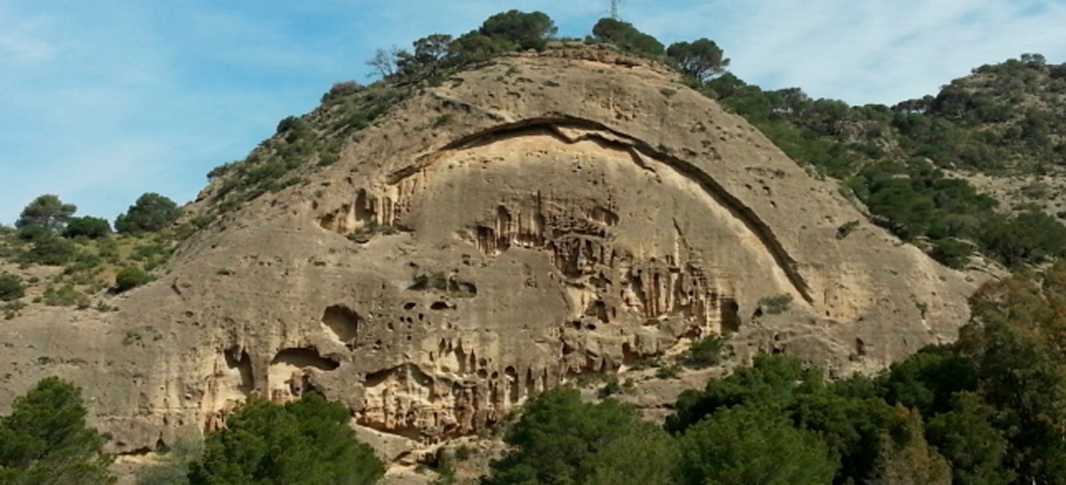
Paleorelieve:
En el entorno del Desfiladero de los Gaitanes se observa un vigoroso paleorrelieve labrado en las margas y margocalizas del Cretácico, actualmente fosilizado bajo las rocas del Mioceno. Los estratos cretácicos, intensamente deformados, contrastan con los estratos miocenos, horizontales, ofreciendo un espectacular ejemplo de discordancia erosiva.
(ENGLISH)
Paleorelief:
In the surroundings of the Desfiladero de los Gaitanes there is a vigorous paleorrelieve carved in the marls and margocalizas of the Cretaceous, currently fossilized under the rocks of the Miocene. The Cretaceous strata, intensely deformed, contrast with the Miocene, horizontal strata, offering a spectacular example of erosive discordance.

(ESPAÑOL)
DISOLUCIÓN CÁRSTICA.
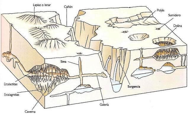
Con el nombre de karst (del alemán Karst: meseta de piedra caliza), carsto carso se conoce a una forma de relieve originado por meteorización química de determinadas rocas (como la caliza, dolomía, aljez, etc.) compuestas por minerales solubles en agua.
Un karst se produce por disolución indirecta del carbonato cálcico de las rocas calizas debido a la acción de aguas ligeramente ácidas. El agua se acidifica cuando se enriquece en dióxido de carbono, por ejemplo cuando atraviesa un suelo, y reacciona con el carbonato, formando bicarbonato, que es soluble. Hay otro tipo de rocas, las evaporitas, como por ejemplo el yeso, que se disuelven sin necesidad de aguas ácidas. Las aguas superficiales y subterráneas van disolviendo la roca y creando galerías y cuevas que, por hundimiento parcial, forman dolinas y, por hundimiento total, forman cañones.
(ENGLISH)
CAASTIC DISSOLUTION.
With the name karst (from the German karst: limestone plateau), carsto carso is known as a relief caused by chemical weathering of certain rocks (such as limestone, dolomite, aljez, etc.) composed of water-soluble minerals. .
A karst is produced by indirect dissolution of the calcium carbonate of limestone rocks due to the action of slightly acid waters. Water becomes acidified when it is enriched in carbon dioxide, for example when it crosses a soil, and reacts with carbonate, forming bicarbonate, which is soluble. There is another type of rock, the evaporites, such as gypsum, which dissolve without the need for acid waters. The superficial and underground waters dissolve the rock and create galleries and caves that, by partial subsidence, form sinkholes and, by total collapse, form canyons.
(ESPAÑOL)
El río tiene generalmente un color lechoso y una cierta turbiedad provocada por los sedimentos en suspensión. Se trata sobre todo de arcillas y materiales provenientes de los yesos de las Comarcas del Guadalteba y Antequera, lo que le aporta también una cierta salinidad al agua. Ya cerca de los cañones los tres cursos fluviales cortan los paquetes de areniscas y conglomerados calcáreos del Mioceno. Así, las aguas arrastran granos de arena y cantos rodados, lo que unido al desnivel que salvan (algo más de 100 m en poco más de 3.5 km) y al enorme caudal en época de lluvias proporciona al Guadalhorce un potencial de erosión muy importante.
(ENGLISH)
The river usually has a milky color and a certain turbidity caused by suspended sediments. It is mainly about clays and materials from gypsum from the regions of Guadalteba and Antequera, which also brings a certain salinity to the water. Near the canyons, the three river courses cut the packs of sandstone and calcareous conglomerates of the Miocene. Thus, the waters drag grains of sand and boulders, which together with the slope they save (just over 100 m in just over 3.5 km) and the enormous flow in the rainy season provides the Guadalhorce with a very important erosion potential.

(ESPAÑOL)
Los roquedos macizos de colores grises y rojos con los relieves más acusados son de caliza y dolomía de edad jurásica. Estos sedimentos de origen marino sufrieron un levantamiento durante el Plegamiento Alpino que modificó su original estratificación horizontal y fracturó el conjunto enormemente. La acción del río ha conformado en esas rocas dos zonas de gargantas encajadas, los llamados Gaitanejos (al norte) y Gaitanes (al sur), respectivamente. En el Cerro del Cristo, en Gaitanes, los paquetes calizos son verticales y han sido cortados perpendicularmente, lo que genera las estampas más impactantes.
(ENGLISH)
The rocky massifs of gray and red colors with the sharpest reliefs are limestone and dolomite of Jurassic age. These sediments of marine origin suffered an uplift during the Alpine Folding that modified its original horizontal stratification and fractured the whole enormously. The action of the river has formed in these rocks two areas of gorges fitted, the so-called Gaitanejos (to the north) and Gaitanes (to the south), respectively. In the Hill of the Christ, in Gaitanes, the limestone packages are vertical and have been cut perpendicularly, which generates the most impressive pictures.


(ESPAÑOL)
Paraje Natural.
Además la zona está dentro del Paraje Natural Desfiladero de los Gaitanes
En el centro de la provincia, entre los municipios de Álora, Antequera y Ardales. Constituye uno de los paisajes más espectaculares de la sierra malagueña, con paredes escarpadas y de altura considerable, entre las que discurre el río Guadalhorce después de pasar por los embalses de El Chorro, Guadalhorce, Guadalteba y Gaitanejo.
(ENGLISH)
Natural Place.
In addition, the area is within the Natural Gorge Desfiladero de los Gaitanes
In the center of the province, between the municipalities of Álora, Antequera and Ardales. It constitutes one of the most spectacular landscapes of the Malaga mountain range, with steep walls and of considerable height, between which the Guadalhorce River flows after passing through the reservoirs of El Chorro, Guadalhorce, Guadalteba and Gaitanejo.

(ESPAÑOL)
Para registrar este Earth Caché:
Para poder dar por bueno tu registro, resuelve las siguientes cuestiones y mándamelas por mail o por mensaje a través de geocaching.com.
- ¿Qué tipo de procesos han dado lugar para formar la geomorfología de la zona?
- ¿Cuándo se produce un karst?
- ¿Qué tipo de hundimiento crees que ha originado el desfiladero?
- En la zona de coordenadas a parte del cartel que nos explica la geología hay un segundo cartel. ¿Qué tipo de cartel es?
Agradeceríamos cualquier foto que se quiera añadir en el log.
Muchas gracias a este Earth Caché, esperamos que haya sido de tu agrado.
(ENGLISH)
To log this Earth Caché:
To be able to consider your registration as good, solve the following questions and send them to me by email or by message through geocaching.com.
1. What kind of processes have given rise to form the geomorphology of the area?
2. When is a karst produced?
3. What type of subsidence do you think the gorge has originated?
4. In the area of coordinates apart from the poster that explains the geology there is a second sign. What kind of poster is it?
We would appreciate any photo that you want to add in the log.
Thank you very much to this Earth Caché, we hope you have been to your liking...