Cleveland Dam is founded mainly on the Coast Range Batholith, a huge body of rock that ranges from Vancouver to the Yukon. It comprises granodiorite and quartz diorite with intrusions of volcanic rocks at the dam.
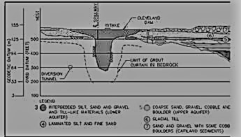
The most interesting thing about the Dam however is the recent (glacial) geology of the Capilano River valley around the damsite. In proglacial times the valley around the dam was much wider than the present canyon and extended east of the present valley. During glaciation, ice dammed the main river channel, and during deglaciation as the ice dam melted, the water impounded behind the dam eventually overtopped it and carved the present narrow canyon along a weak plane (fault) in the bedrock. That left the old channel filled with glacial till (a clay-gravel mixture typically impervious to water) with layers and channels of sand and gravel (which are quite pervious to water) exposed on the canyon’s east wall upstream of Cleveland Dam. The ancestral valley and the new valley meet above Highway 1.
Cross section of the valley at the dam looking upstream. Note the ancestral valley on the right.
This process is actually quite common in BC and many of the dams built in BC are in the new channel with the ancestral channel beside it. Dams such as the Peace River W.A.C. Bennett Dam and the Columbia River Revelstoke Dam are two such examples, but there are more as it makes sense to put a dam in a narrow canyon.
When the Cleveland Dam was built in the canyon in 1954, the engineers dealt with seepage around the dam through the buried channel on the east bank by placing an impervious glacial till/clay blanket over it upstream of the dam. This made a long water seepage path and therefore reduced seepage through the channel around the dam. The “fix” never worked very well however and the dam leaked for 50 years. The leakage was controlled by drainage adits and monitored by water pressure gauges.
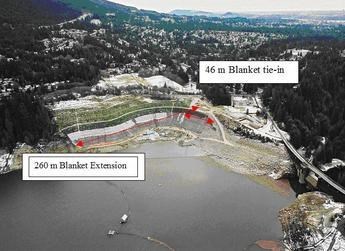
Over the years the leakage got worse and in 2001 construction started on a better fix. That involved making the upstream impervious blanket much larger, placing an impervious concrete “curtain” trench into the upstream soil and adding a few more drainage adits. This fix worked, the dam seeps much less now and its seepage is well controlled.
Photo taken in about 2002 shows the old blanket (46m) and the new blanket (260 m) added to the old blanket. Dam is on the right and the ancestral, buried valley is on the left. The reservoir is drained.
To log this cache you must answer by email or message me the following questions. Please send your answers at the time of logging so you don't forget.
1. Standing at the posted coordinates, there is a tunnel near the base of the spillway on the right bank. What do you think this tunnel was used for?
2. Can you guess why this tunnel (adit) is still used?
3. There are two places where younger new channel joins up with the ancestral channel. One is at the dam when it leaves, and the other is where the two channels rejoin; where would you guess the two come together further downstream? Out of town cachers will be cut some slack on this one.
4. Can you see the blanket that was added on the left (east) bank from the dam.
For more complete information go to (http://www.waterpowermagazine.com/features/featurethe-case-of-cleveland-dam/)