
Les cavités de Chambray (Eure)
Des carrières à paroi naturelle dans les calcaires tertiaires

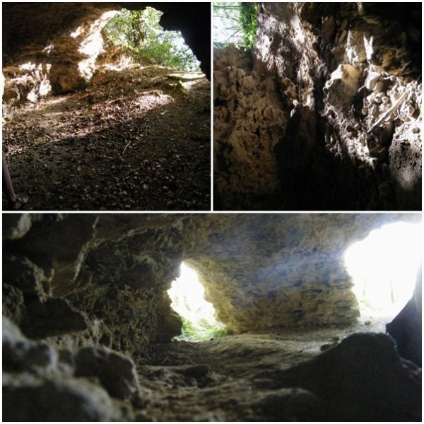
La Haute-Normandie est presque toujours associée à son karst de la craie. En conséquence, nous oublions parfois que la craie n’est pas la seule formation géologique de la région. En effet, le centre du bassin de Paris est constitué de dépôts tertiaires qui recouvrent la marge orientale de la Normandie, notamment entre Seine et Eure, à l’est du département de l’Eure. Ils masquent les dépôts crayeux du Crétacé supérieur qui se développent en dessous. Ces dépôts tertiaires offrent différents faciès, parmi lesquels ont été identifiés des sables et des calcaires. Ces derniers ont été largement exploités et utilisés traditionnellement dans la construction de bâtiments et de murs. Dans la vallée de l’Eure, principal affluent de rive gauche de la Seine normande, ces calcaires sont perchés au sommet des coteaux dont ils assurent la rigidité et la platitude. Durant de nombreuses décennies, ces affleurements ont été exploités pour la construction, dégageant un front d’exploitation, parfois percé d’une multitude de cavités. C’est le cas ici à Chambray, à quelques kilomètres au nord-ouest de Pacy-sur-Eure.
Les formes karstiques de ces cavités soulèvent la question du contexte de leur genèse. En effet, avant l’incision de la vallée de l’Eure, le plateau n’est encore qu’une plaine légèrement émergée, sans aucune entaille. Le drainage est essentiellement superficiel, et l’absence d’un gradient hydraulique n’autorise pas une attaque différentielle de l’encaissant par l’altération superficielle (1). Il n’y a donc pas de karstification de l’encaissant. Il faut donc envisager une certaine surrection de la plaine pour permettre la mise en place d’un aquifère phréatique sous ce qui deviendra un plateau. Cela est possible au cours du Pléistocène inférieur. Dans les calcaires de Chambray, deux types de morphologie karstique s’opposent.
Le premier type, phréatique, traduit un gradient hydraulique réduit qui n’est pas compatible avec l’incision actuelle de la vallée de l’Eure. Ce mécanisme repose sur l’existence d’un aquifère présent dans les sables yprésiens et dont le toit ou la surface viendrait battre dans les calcaires. Ce battement est suggéré par le niveau altéré au contact calcaires/sables. Il signifie que l’aquifère est contenu sous le plateau, sans fuite périphérique conséquente. Donc, il n’y a pas de vallée profonde à proximité, et on doit envisager que la vallée de l’Eure n’offre alors qu’une légère entaille dans les plateaux normands (2).

Le second type, à tendance vadose, est moins représenté sur le site. Il accompagne un abaissement du niveau de base, entraînant un écoulement concentré et rapide dont le creusement en gorge étroite et profonde répond à un effet de descente. Cette dynamique souligne un effet d’exondation des cavités phréatiques, et la fossilisation du réservoir phréatique. Ceci signifie que l’aquifère s’échappe rapidement du plateau (effet de vidange), vers un nouveau réservoir situé plus bas. On est tenté de rapprocher ce phénomène de la phase d’incision majeure de la vallée de l’Eure, en dessous des formations yprésiennes, atteignant vraisemblablement le substrat crayeux. Aujourd’hui, le plateau de Rouvray domine le talweg de l’Eure de près de 90 m, suspendant la table calcaire lutétienne haut au-dessus du fond de la vallée. Cette profonde entaille s’est inscrite dans les formations crayeuses du Crétacé supérieur, après avoir traversé les dépôts tertiaires. On peut légitimement envisager que le creusement de cette dépression ait pu vidanger l’aquifère phréatique des calcaires lutétiens. En conséquence, l’enfoncement de l’entaille de l’Eure aurait entraîné le creusement des drains vadoses.
La vallée de la Seine et ses principaux affluents, dont l’Eure, se sont fortement incisés à la rupture Pléistocène inférieur/Pléistocène moyen, il y a environ 800 000 ans. C’est donc dans cette même période que le karst de Chambray a pu se fossiliser, au profit d’un nouvel aquifère, puissant, installé dans les formations crayeuses, ce dernier affleurant dans la vallée, et accompagnant le drainage superficiel de l’Eure. L’érosion superficielle accompagnant le creusement et le calibrage de la vallée de l’Eure recoupe, certainement, plusieurs drains qui, beaucoup plus tard, attireront les carriers (3).
Pour valider cette earthcache vous devrez répondre aux questions suivantes :
-
Citez les deux types de morphologie karstique qui s’opposent sur ce site de Chambray.
-
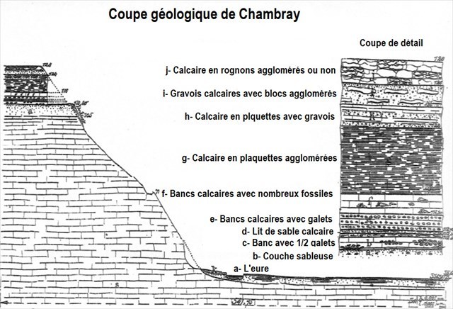
En observant la paroi de la grotte et en vous aidant de la coupe géologique, déterminez sur quelle couche géologique vous vous trouvez.
-
(En option) A l’intérieur de la grotte se trouve un superbe campanile giganteum sur une paroie. Saurez vous le retrouver et le photographier ?

Loguez cette cache "Found it" et envoyez-moi vos propositions de réponses soit via mon profil, soit via la messagerie geocaching.com, et je vous contacterai en cas de problème.

Normandy is almost always associated with its chalk karst. As a result, we sometimes forget that chalk is not the only geological formation in the region. Indeed, the center of the Paris Basin is made up of tertiary deposits that cover the eastern margin of Normandy, particularly between Seine and Eure, east of the Eure department. They mask the chalky deposits of the Upper Cretaceous that develop below. These tertiary deposits offer different facies, among which have been identified sands and limestones. These have been widely exploited and used traditionally in the construction of buildings and walls. In the Eure Valley, the main tributary of the left bank of the Norman Seine, these limestones are perched at the top of the slopes, which they provide rigidity and flatness. For many decades, these outcrops have been exploited for construction, creating an exploiting front, sometimes pierced by a multitude of cavities. This is the case here in Chambray, a few kilometers north-west of Pacy-sur-Eure.
The karst forms of these cavities raise the question of the context of their genesis. Indeed, before the incision of the valley of the Eure, the plateau is still only a plain slightly emerged, without any notch. The drainage is essentially superficial, and the absence of a hydraulic gradient does not allow a differential attack of the host by the superficial alteration (1). There is no karstification of the country. It is therefore necessary to consider some uplift of the plain to allow the establishment of a phreatic aquifer under what will become a plateau. This is possible during the lower Pleistocene. In the limestones of Chambray, two types of karstic morphology oppose each other.
-
The first type, phreatic, reflects a reduced hydraulic gradient that is not compatible with the current incision in the Eure Valley. This mechanism is based on the existence of an aquifer present in the Ypresian sand and whose roof or surface would beat in the limestone. This beat is suggested by the altered level in limestone / sand contact. It means that the aquifer is contained under the plateau, without consequent peripheral leakage. So there is no deep valley nearby, and we must consider that the valley of the Eure offers only a slight cut in the Norman plateaus (2).
-
The second type, with vadose tendency, is less represented on the site. It accompanies a lowering of the base level, resulting in a concentrated and rapid flow whose deepening in narrow and deep groove responds to a descent effect. This dynamic emphasizes an effect of the excavation of the phreatic cavities, and the fossilization of the phreatic reservoir. This means that the aquifer quickly escapes from the plateau (draining effect) to a new, lower reservoir. We are tempted to compare this phenomenon with the major incision phase of the Eure Valley, below the Ypresian formations, probably reaching the chalky substrate. Today, the plateau of Rouvray dominates the talweg of the Eure of nearly 90 m, suspending the Lutetian limestone table high above the bottom of the valley. This deep cut was recorded in the chalky formations of the Upper Cretaceous, after passing through tertiary deposits. We can legitimately consider that the digging of this depression could have drained the phreatic aquifer of Lutetian limestones. Consequently, the depression of the cut of the Eure would have caused the digging of vadose drains.
The Seine valley and its main tributaries, including the Eure, strongly incised themselves at the lower Pleistocene / Middle Pleistocene rupture about 800,000 years ago. It is therefore in this same period that the karst of Chambray was able to fossilize, in favor of a new aquifer, powerful, installed in the chalky formations, the latter outcropping in the valley, and accompanying the superficial drainage of the Eure . The superficial erosion accompanying the digging and grading of the Eure Valley certainly involves several drains which, much later, will attract quarries (3).
To validate this earthcache you will have to answer the following questions:
• Cite the two types of karstic morphology oppose on this site of Chambray.
• By observing the wall of the cave and using the geological section, find out which geological layer you are on,
• A non-mandatory photo may be optional.
• (In option) Inside the cave is a beautiful campanile giganteum on a paroie. Find it and estimate its diameter in cm.
Log this cache "Found it" and send me your proposed answers either via my profile or via geocaching.com messaging, and I will contact you in case of problems.