VS#1417 Knowle Multi-cache
-
Difficulty:
-

-
Terrain:
-

Size:  (other)
Please note Use of geocaching.com services is subject to the terms and conditions
in our disclaimer.
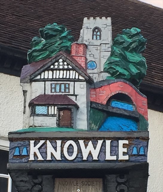
The name Knowle is derived from the Saxon 'Cnolle' which means a small hill. It appears in documents as 'Gnolle' 'Knolle', 'Knole' and 'Knoll' before the present spelling became standard from about the mid-19th century.
At the time of the Domesday Survey in 1086, Knowle was a hamlet within the parish of Hampton-in-Arden and is not separately recorded. It became a separate parish in 1859.
The first record of Knowle is a document from about 1200 in which William de Arden conveys the 'whole town of Gnoll' to his wife Amice de Traci. Knowle became a Royal Manor in 1285 when the de Arden family sold it to King Edward I and Queen Eleanor. After the queen's death in 1290, King Edward gave the Manor of Knoll to the Abbot and Priors of Westminster and instructed that masses be said for the soul of Queen Eleanor.
In 1396, Walter Cook applied for a faculty to build a church in 'Knoll' and this was granted by Pope Boniface IX on 4th May 1396. Construction was so far advanced by 1399 that services could be held there. The church was built entirely of white Arden sandstone from a quarry in Rowington. On 24th February 1402 the church was consecrated to the glory of God and in honour of St John the Baptist, St Lawrence the Martyr and St Anne.
In 1412, Walter Cook founded, with 6 other men, the Guild of St Anne of Knowle, an early form of friendly society providing aid in sickness, poverty and old age. The church was enlarged so that guild members could comfortably meet there. Most of this work was carried out in red sandstone brought from Kenilworth.
Now onto the cache:
The sum of all the digits in the year the sign was erected = A
Year on the side of the bench at the base of the sign =BCDE
Number of the house behind the sign = 1FG1
Now across the road to the second way point, you will see a blue plaque on the wall of the Red Lion:
The Street number = 1HJK
The year the Red Lion became a Grade 2 listed building = 1LMN
The cache can be found at:
N52 2(B+G).(KxG) (J-A) ((CxN)+E)
W001 4(H-E).(L-G) (E+D) ((J/M)+F)
If anybody would like to expand this series please do. I would just ask that you let Smokeypugs know first so they can keep track of the Village Sign numbers and names to avoid duplication.
 Village sign#1417 Knowle
Additional Hints
(Decrypt)
Ba terra ohg abg vil, ybj YUF