Batupasir – DP/EC OneO’Six

Sandstone is a clastic sedimentary rock composed mainly of sand-sized (0.0625 to 2 mm) mineral particles or rock fragments.
Most sandstone is composed of quartz or feldspar because they are the most resistant minerals to weathering processes at the Earth's surface, as seen in Bowen's reaction series. Like uncemented sand, sandstone may be any color due to impurities within the minerals, but the most common colors are tan, brown, yellow, red, grey, pink, white, and black. Since sandstone beds often form highly visible cliffs and other topographic features, certain colors of sandstone have been strongly identified with certain regions.
Regional Geologic Setting
The Arrábida Mountain has a very complex structure; is formed by an asymmetric anticline with vergence to the South.
In the northern flank of this structure, outcrop all the units between the Liassic (lower Jurassic) and the Miocene, increasing the slope of the layers as we moves southwards, and decreasing again in the hinged zone of the Formosinho anticline (Kullberg & Kullberg, 1996). In this flank we can observe rocks of various natures: dolomites, limestones, marls, clays, sandstones, conglomerates and sands.
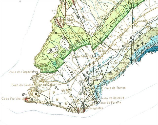
The southern slope of the Arrábida Mountain, which is very abrupt, is constituted by the Convent Dolomites (Lower to midlle Jurassic). The layout of this slope is determined by a large basal thrust that affects the Miocene of the Portinho da Arrábida to the east, and extends to the west through the valley of the Mata do Solitário. It is this imposing coastal escarpment that gives the Arrábida Mountain its originality, where we can observe forms of marine and sub-aerial erosion; the first stands out as coastal cliffs and reefs; the second, the cornices and their colluvial deposits (Manuppella et al., 1999).
The cache is located in the geological unit named in the 1: 50000 of Setúbal (Sheet 38-B) "Grés, Argilas e Cálcários gresosos de Guia e Vale de Lobos" with Valanginian and Lower to Middle Berriasian (Lower Cretaceous). These two formations, which are not separated cartographically in Sheet 38-B (Setúbal), are formed by kaolinitic arenites, fine to coarse grained, with rolled quartz clasts dispersed in the sandstone forming lenses with interlaced internal stratification alternating with fine arenites and grey and violate lignite clays. On these overlie at least 5m of yellow limestones.
The EarthCache
To register your found in this EC, you have to observe the outcrop on the roadside and answer the following questions:
- Is the rock a homogeneous colour or does it vary?
- Can you see the individual grains that make up the rock?
- The outcrop is marked by several pebble horizons (these are mostly made up of white quartz – so easy to ID). Tell me the smallest and largest diameter you can find within a 1.5m radius of the GZ coordinates.

Arenito ou grés é uma rocha sedimentar que resulta da compactação e litificação de um material granular da dimensão das areias. O arenito é composto normalmente por quartzo, mas pode ter quantidades apreciáveis de feldspatos, micas e/ou impurezas. É a presença e tipo de impurezas que determina a coloração dos arenitos; por exemplo, grandes quantidades de óxidos de ferro, fazem esta rocha vermelha.
Enquadramento geológico regional
A Serra da Arrábida tem uma estrutura bastante complexa; é formada por um anticlinal assimétrico com vergência para Sul.
No flanco Norte desta estrutura afloram todas as unidades compreendidas entre o Liássico (Jurrásico inferior) e o Miocénico, aumentando a inclinação das camadas à medida que se caminha para Sul, e diminuindo novamente na zona de charneira do anticlinal do Formosinho (Kullberg & Kullberg, 1996). Neste flanco podemos observar rochas de várias naturezas: dolomitos, calcários, margas, argilas, arenitos, conglomerados e areias.
A vertente Sul da Serra da Arrábida, que é muito abrupta, é constituída pelos Dolomitos do Convento (Jurássico inferior a médio). O traçado desta vertente é determinado por um grande cavalgamento basal que afecta o Miocénico do Portinho da Arrábida a leste, e se prolonga para Oeste pelo vale da Mata do Solitário. É esta imponente escarpa litoral que confere `serra da Arrábida a sua originalidade, onde podemos observar formas de erosão marinha e sub-aérea; da primeira destacam-se as arribas litorais e as rechãs; da segunda, destacam-se as cornijas e respectivos depósitos coluviais (Manuppella et al., 1999).
A cache encontra-se na unidade geológica denominada na carta 38-B 1:50000 de Setúbal “Grés, Argilas e Cálcários gresosos de Guia e Vale de Lobos” com idade Valanginiano e Berriasiano Inferir e médio (Cretácico Inferior). Estas duas formações não separadas cartograficamente na Carta 38-B (Setúbal), são formadas por grés brancos cauliníticos, finos a grosseiros, com calhaus rolados de quartzo dispersos na massa arenítica formando lentículas com estratificação interna entrecruzada alternado com grés finos e argilas linhitosas cinzentas e violáceas. Sobre estes assentam pelo menos 5m de calcários gresosos amarelos.
A EarthCache
Para registrar esta EC, deves observar o afloramento na estrada e responder `às seguintes perguntas:
1- A rocha é de cor homogénea ou varia?
2- Consegues ver os grãos individuais que compõem a rocha?
3- O afloramento é marcado por vários horizontes de cascalho (estes são principalmente compostos de quartzo branco - fácil de identificar). Diz-me o menor e maior diâmetro que podes encontrar dentro de um raio de 1,5 m das coordenadas do GZ.
Note 1/Nota 2: Batupasir = Sandstone = Arenito (em Bahasa)
Note 2/Nota2: Sources:
Manuppella et al., (1994) Carta 1:50000, Folha 38-B (Setúbal). Instituto Geológico e Mineiro.
Manuppella et al., (1999) Notícia explicativa da Folha 38-B (Setúbal). Instituto Geológico e Mineiro, 143p.

 The most exciting way to learn about the Earth and its processes is to get into the outdoors and experience it first-hand. Visiting an Earthcache is a great outdoor activity the whole family can enjoy. An Earthcache is a special place that people can visit to learn about a unique geoscience feature or aspect of our Earth. Earthcaches include a set of educational notes and the details about where to find the location (latitude and longitude). Visitors to Earthcaches can see how our planet has been shaped by geological processes, how we manage the resources and how scientists gather evidence to learn about the Earth. To find out more click HERE.